Common Issues- If your Garmin Oregon
6x0 is exhibiting bad behavior you do not see listed here, please post a new thread about your experience and send a detailed error report to Garmin, as outlined below.
- If you do see your issue listed here, please send your detailed error report to Garmin! They need to hear from all users.
- Please handle all feature requests similarly: Post a new thread if not already listed, and send a copy to Garmin.
-
If you see your request is already listed, copy and paste it to Garmin! The more frequently they see the same request, the more likely they are to include it in a future update.
Error Reporting
- Please report all software bugs, glitches, crash reports, and feature requests in the
Oregon 6x0 discussion forum.
-
Include as much detail as possible when describing each issue you are experiencing, including profile settings, maps installed/enabled, keystrokes, etc.
-
Send a copy of your post to
product.support@Garmin.com and include:
- a copy of the
system.xml file from the [GPSr]\Garmin\ directory.
-
a copy of the
GarminDevice.xml file located in the [GPSr]\Garmin\ directory.
-
any
*.gpx files associated with the crash or bug from the [GPSr]\Garmin\GPX\ or
[microSD]\Garmin\GPX\ directories.
-
any
*.ggz files associated with the crash or bug from the [GPSr]\Garmin\GGZ\ or
[microSD]\Garmin\GGZ\ directories.
Status
- RED: Issue/Feature Request has been reported to Garmin, and is pending response.
-
ORANGE: Garmin has acknowledged a Reported Issue/Feature Request and may be working on a solution.
-
GREEN: Issue has been resolved and no longer exists. Requested Feature has been implemented.
Categories
- Bugs (35/03/44): Software issues that result in a system failure or adversely affect intended functionality.
-
Crash Reports (07/01/14): Bugs resulting in unintentional hanging, freezing, resetting or powering down.
-
Hardware Failures (03/00/00): Physical issues and/or failures that limit or inhibit intended function.
-
Missing Features (05/00/00): Feature is available on a similar Garmin outdoor handheld product.
-
Requested Features (40/02/00): Request for functionality not present with current firmware version.
Bugs
- Scrolling down in [Current Track > Information] using scroll arrows, the page does not hold position, and instead jumps back to the top of the page. [Video] [11MAY13] [2.60] [Resolved 2.70]
-
While viewing chirp information in [Geocaching > Chirp], pressing the power button fails to open the Status Page [or user defined action], and instead opens the Map application and routes to the active chirp coordinates, behaving as if the user had selected [Go] from the same page. [11MAY13] [2.60] [2.70] [3.10] [Resolved 3.30]
-
Configuring the Power Button to take screenshots [Setup > Display > Screen Capture > On] disables all User Button functions. [12MAY13] [2.60] [2.70] [2.80] [2.90] [3.10] [3.20] [3.30] [3.50] [3.70] [3.80] [3.90] [4.10]
[4.20] [4.30] [4.40] [4.60] [4.80] [4.90] [5.00] [5.10] [5.20] [5.30]
[5.40] [5.50] [5.60]
-
Battery charge indicator does not display charge percentage while charging, and appears to never reach a full (100%) charge. [12MAY13] [2.60] [Resolved 2.70]
-
Page Loop feature does not return user to the application screen active when page loop sequence was started, instead it always returns user to Main Menu. [wiki] [19MAY13] [2.60] [2.70] [Garmin reports this is intentional]
-
Geocaching Filter settings are not always retained with Swedish, German, Portuguese or Dutch language enabled. [wiki] [wiki] [20MAY13] [2.60] [2.70] [2.80] [2.90] [Resolved 3.10]
-
Filtering waypoints by symbol in Waypoint Manager and selecting [Delete] results in complete waypoint database being deleted. [wiki] [20MAY13] [2.60] [Resolved 2.70]
-
Geocaches with size 'Not Chosen' are not displayed in the Map application, regardless of geocache filter settings. The same geocaches are visible in the GCUI list, and will appear on the map when viewed within the GCUI. [wiki] [Groundspeak] [22MAY13] [2.60] [2.70] [Resolved 2.80]
-
Selecting [Waypoint Averaging] displays a list of nearby waypoints sorted by proximity, but greatly exaggerates the distance to each waypoint. [wiki] [22MAY13] [2.60] [Resolved 2.70]
-
Geocaches with container size 'unknown' are improperly displayed as 'large' in geocache descriptions. [wiki] [23MAY13] [2.60] [Resolved 2.70]
-
Geocaching quick filter selections are not always properly retained. [wiki] [24MAY13] [2.60] [2.70] [2.80] [2.90] [3.10] [3.20] [3.30] [3.50] [3.60] [3.70] [3.80] [3.90] [4.10]
[4.20] [4.30] [4.40] [4.60] [4.80] [4.90] [5.00] [5.10] [5.20] [5.30] [5.40]
[5.50] [5.60]
- Set language to English so the filters are working (See Bug 06)
- Select main menu
- Open geocaching
- Select filter (upper right corner) if not preselected
- Select quick filter (lower right corner)
- Choose 'Virtual'
- The virtual icon is selected, all other types are greyed out (as expected)
- Close geocaching (lower left corner)
- Open geocaching again
- Select quick filter (lower right corner)
- Choose 'Show All'
- All cache types are activated and no longer greyed out (as expected)
- Select the cache icons for editing
- Virtual is the only geocache type enabled in the menu ('Show All' was just selected)
- Select back (lower left corner)
- The virtual icon is selected and all other types are greyed out ('Show All' was just selected)
- User created geocache filters always behave identical to 'Show All' filter, regardless of settings, when any language other than English is selected. [wiki] [wiki] [24MAY13] [2.60] [2.70] [2.80] [2.90] [Resolved 3.10]
-
Compass randomly exhibits erratic and/or unstable behavior. [wiki] [video] [28MAY13] [2.60] [Resolved 3.10]
-
UserData.sqlite3 file intermittently will not update properly, resulting in incorrect/mismatched geocache data being displayed. [wiki] [28MAY13] [2.60] [Resolved 2.70]
-
Oregon
6x0 will not properly eject from Win7/Win8 when a µSD card is not present. [wiki] [30MAY13] [2.60] [2.70] [2.80] [2.90] [3.10] [3.20] [3.30] [3.50] [3.60] [3.70] [3.80] [3.90] [4.10]
-
Geocaches with container size 'not chosen' are improperly displayed as 'micro' in geocache descriptions when read from GGZ files. [wiki] [gsak] [31MAY13] [2.70] [Resolved 3.10]
-
After entering Next Stage coordinates while searching for a geocache, the Difficulty, Terrain, Size and Awesomeness rating are not correctly retained. [wiki] [example] [03JUN13] [2.60] [2.70] [3.10] [Resolved 3.20]
-
Track Manager intermittently fails to display track log ascent, descent, and elevation data when present. [wiki] [03JUN13] [2.70] [2.80] [2.90] [3.10] [3.20] [3.30] [3.50] [3.60] [3.70] [3.80] [3.90] [Resolved 4.10]
-
Using Sight 'N Go to
set a course without [Setup > Heading > Go To Line/Pointer > Course (CDI)] selected results in CDI Drift Scale controls (– +) not being displayed. [09JUN13] [2.70] [3.10] [3.20] [3.30] [3.50] [3.60] [Resolved 3.70]
-
Map Configuration settings for any given shortcut are not retained after opening the shortcut for additional editing, rendering map configuration settings for the edited shortcut non functional. [example 1] [example 2] [09JUN13] [2.70] [2.80] [2.90] [3.10] [3.20] [3.30] [3.50] [3.60] [3.70] [3.80] [3.90] [4.10]
-
When activating a shortcut to toggle the screen lock via hardware button, the lock icon in the lower left corner of the screen is not promptly refreshed and does not provide a true indication of screen lock status, both when locking and unlocking. Only after touching the screen in the lower left corner is a warning displayed and the icon properly refreshed. [wiki] [12JUN13] [2.70] [3.10] [3.20] [3.30] [3.350] [3.60] [Resolved 3.80]
-
Touching the screen while locked generates a warning message. Selecting [OK] returns the user to the currently open application. If a dashboard is active, it will flicker when the 'screen locked' message is being presented and cleared. [12JUN13] [2.70] [Resolved 3.10]
-
Saving a track log recording via the Current Track application or
Track Control dashboard (with 200 total favorite tracks) results in 'Export Complete' and 'Saved track as...' confirmation messages, but no track log data is actually saved on the device. [15JUN13] [2.70]
-
Saving a portion of the current track and then viewing the saved track data in Track Manager will display statistics and other totals for the full track, not the saved portion. [Garmin DE] [15JUN13] [2.70] [2.80] [2.90] [3.10] [3.20] [3.30] [3.50] [3.60] [3.70] [3.80] [3.90] [4.10] [4.20] [4.30] [Resolved 4.40]
-
Geocaches of 'Virtual' type or 'Not Chosen' size are not displayed in the Map application, regardless of geocache filter settings. [16JUN13] [2.70] [Resolved 2.80]
-
The Menu button is not available while viewing [Geocache List] in Landscape mode when [Setup > Appearance > Landscape Controls > Right]. [wiki] [18JUN13] [2.70] [Resolved 2.80]
-
Distances to geocaches in [Geocache List] with two or more digits before the decimal are partially obstructed by the geocache size display when viewed in Portrait Mode and [Setup > Geocaching > Geocache Style > {Traditional} or {Auto}]. [wiki] [18JUN13] [2.70] [Resolved 2.80]
-
After entering next stage coordinates with an active geocache destination, the geocaching dashboard should display 'Next Stage' as the new destination using the supplied coordinates. This feature always fails for some geocaches. Example; GC3H3G6 functions properly while GC4B75W does not. [wiki] [20JUN13] [2.70] [2.80] [2.90] [3.10] [3.20] [3.30] [3.50] [3.60] [3.70] [3.80] [3.90] [Resolved 4.10]
-
Oregon
6x0 frequently provides sub-standard GPS accuracy, commonly reporting current position 100' or more from actual position. [wiki] [groundspeak] [example 1] [example 2] [example 3] [Garmin DE] [Garmin DE] [Garmin DE] [26JUN13] [2.70] [2.80] [2.90] [3.10] [3.20] [3.30] [3.50] [3.60] [3.70] [3.80] [3.90] [Improved 4.10] [4.20] [4.30] [4.40]
-
Share Wirelessly application fails to function as advertised between compatible Garmin GPSr. [wiki] [Garmin DE] [example] [29JUN13] [2.70] [2.80] [2.90] [3.10] [3.20] [3.30] [3.50] [3.60] [3.70] [3.80] [3.90] [4.10] [4.20] [4.30] [4.40] Garmin: "There is a known issue with older devices sometimes having issues sharing things via ANT+ (especially long tracks). A comprehensive update was made awhile ago to Oregon 600 which should solve a lot of the issues when sending from and Oregon 600 to another unit. However that update cannot help with sending from another unit to the Oregon 600, as the unit doing the sending sets up the communication channel and protocol. Sufficiently large items (like a custom map or a really long track) will trigger transfer over Bluetooth if the receiving unit supports it (another Oregon 600 or a GPSMAP 64 for example), and by doing this avoids the issue. Updating the code driving the ANT+ transfers was a serious endeavor and very time-consuming which means it probably won’t happen to older devices." [23JAN15]
-
[Setup > Routing > Calculation Method] always shows [Based on Activity] selected, regardless of actual setting. [wiki] [example] [04JUL13] [2.80] [Resolved 2.90]
-
Data fields displaying Tempe sensor information cycle between live reading and blank display (----°F) when Chirp Searching is also enabled. [05JUL13] [2.80] [2.90] [3.10] [3.20] [3.30] [3.50] [3.80] [3.90] [Resolved 4.10]
-
Geocaches (GPX) with sizes 'Other' or 'Not Chosen' are not displayed in the Map application following a power cycle. Selecting [Geocaching > Filters > Show All] resolves the issue. [08JUL13] [2.80] [2.90] [Resolved 3.10]
-
Geocaches (GGZ) with sizes 'Other' or 'Not Chosen' are not displayed in the Map application following a power cycle. Selecting [Geocaching > Filters > Show All] resolves the issue. [08JUL13] [2.80] [2.90] [Resolved 3.10]
-
Geocaches (GPX) with types 'Event', 'Earth Cache' or 'Web Cam' are not displayed in the Map application following a power cycle. Selecting [Geocaching > Filters > Show All] resolves the issue. [08JUL13] [2.80] [2.90] [Resolved 3.10]
-
Geocaches (GGZ) with types 'Event', 'Earth Cache' or 'Web Cam' are not displayed in the Map application following a power cycle. Selecting [Geocaching > Filters > Show All] resolves the issue. [08JUL13] [2.80] [2.90] [Resolved 3.10]
-
Geocaches with container size 'other' (?) are improperly displayed as 'not chosen' (X) in geocache descriptions when read from GGZ files. [08JUL13] [2.80] [2.90] [3.10] [3.20] [3.30] [3.50] [3.60] [3.70] [3.80] [3.90] [4.10] [4.20] [4.30] [4.40]
-
Geocache List search options are not available when all indexed geocaches are beyond maximum list radius. [wiki] [08JUL13] [2.80]
-
Camera application fails to save photos and warn user when required storage space is not available, leading the user to believe photos are being saved. Please add warning (small numeric display indicating available space - similar to most modern cameras) and function to use alternate storage (GPSr or µSD Card) after default storage is full (when available). [wiki] [09JUL13] [2.80]
-
With Current Track visibility set to Show On Map, the active track log recording display intermittently fails to properly refresh. [Example] [16JUL13] [2.70] [2.80] [2.90] [3.10] [3.20] [3.30] [3.50] [3.60] [3.70] [3.80] [3.90] [4.10]
-
Using [Share Wirelessly] to send geocaches stored in GGZ format always results in a garbled/unusable GPX file on the receiving GPSr. [wiki] [wiki] [Garmin] [example] [22JUL13] [2.80] [2.90] [3.10] [3.30] [Resolved 3.50]
-
Oregon
6x0 will not properly eject from Win7/Win8 when connected via USB 3 port. [01AUG13] [2.90] [3.10] [Resolved 3.20]
-
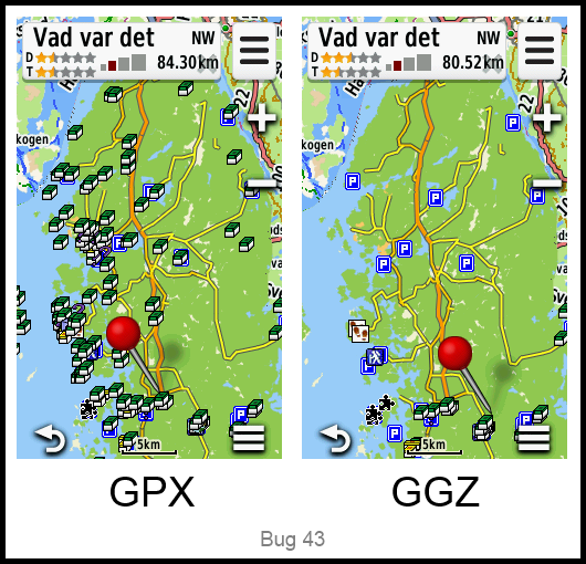
Some geocaches are displayed on the map screen when loaded as GPX, but do not appear when loaded as GGZ, (seemingly) regardless of size, type, language and/or filter settings. [wiki] [Garmin DE] [example] [zip] [17AUG13] [2.90] [3.10] [3.20] [3.30] [3.50] [3.60] [3.70] [3.80] [3.90] [4.10]
-
With [Setup > Altimeter > Auto Calibration > At Power On] selected, Current Track not recording and track log cleared; the Elevation data field display changes from Barometric Elevation to GPS Elevation. [wiki] [example] [21AUG13] [3.10] [3.20] [3.30] [3.50] [3.60] [3.70] [3.80] [3.90] [4.10]
-
Selecting [Setup > ANT Sensor > Bike Cadence Sensor > Search for new] intermittently fails to locate Garmin GSC 10. Firmware 2.70 does not exhibit this behavior. [wiki] [21AUG13] [2.80] [2.90] [3.10]
- All icons below the VIRB icon in the shortcut icon selection menu have been shifted by one position. [21AUG13] [2.90] [3.10] Garmin: "We agree this was a mistake, but it will not be changed - doing so would break profiles from version 3.10 and newer. The order present in 2.90/3.10 is how it will stay in future releases, and new icons will be added to the end."
-
With Current Track recording paused (not recording), changing [Setup > Tracks > Advanced Setup > Trip Recording] from [Always] to [When Tracking] does not pause Trip Computer recording until the Current Track recording is started and paused again. [27AUG13] [3.10] [3.20] [3.30] [3.50] [3.60] [3.70] [3.80] [3.90] [4.10]
[4.20] [4.30] [4.40] [4.60] [4.80] [4.90] [5.00] [5.10] [5.20] [5.30]
[5.40] [5.50] [5.60]
-
Waypoints, Tracks, Photos (etc.) saved between 12:00pm and 12:59pm with [Setup > Time > Time Format > 12 Hour] selected are improperly time stamped as 12:xxam (should be saved as 12:xxpm). [wiki] [05SEP13] [3.10] [3.30] [Waypoints Resolved 3.50] [3.60] [Tracks & Photos Resolved 3.70]
-
Waypoints, Tracks, Photos (etc.) saved between 12:00am and 12:59am with [Setup > Time > Time Format > 12 Hour] selected are improperly time stamped as 00:xx (should be saved as 12:xxam). [wiki] [05SEP13] [3.10] [3.30] [Waypoints Resolved 3.50] [3.60] [Tracks & Photos Resolved 3.70]
-
Adding a new Main Menu Page to the left of the Main Menu Start Page in [Setup > Main Menu] causes all Main Menu Page Dashboards to be shifted to the left by one Main Menu Page while the farthest right Main Menu Page is assigned a seemingly random Dashboard. [05SEP13] [2.90] [3.10] [3.20] [3.30] [3.50] [3.60] [3.70] [3.80] [3.90] [4.10]
[4.20] [4.30] [4.40] [4.60] [4.80] [4.90] [5.00] [5.10] [5.20] [5.30] [5.40]
[5.50] [5.60]
-
Removing all Main Menu Pages to the left and right of the Main Menu Start Page in [Setup > Main Menu] and exiting [Setup] will result in all Main Menu Page icons being hidden. Exiting and re-entering the current profile restores the Main Menu Start Page icons. [05SEP13] [2.90] [3.10] [3.20] [3.30] [3.50] [3.60] [3.70] [3.80] [3.90] [4.10]
[4.20] [4.30] [4.40] [4.60] [4.80] [4.90] [5.00] [5.10] [5.20] [5.30] [5.40]
[5.50] [5.60]
-
Selecting a logged geocache in [Calendar] frequently results in message "Unable to find additional information about this geocache." [05SEP13] [3.10] [Resolved 3.50]
-
Remaining battery capacity display is irregular and unreliable with NiMH batteries installed, displaying 25% or 50% remaining for >75% of actual run time, inhibiting some Oregon
6x0 features. [10SEP13] [2.90] [3.10]
-
Selecting [{Any Adventure} > Content > Photos] may fail to display loaded photos for the selected Adventure. [wiki] [30SEP13] [3.20] [3.30] [See wiki post for resolution]
-
Selecting [{Any Adventure} > Content > Geocaches] may fail to display loaded geocaches for the selected Adventure. [wiki] [30SEP13] [3.20] [3.30] [3.50] [3.60] [3.70] [3.80] [3.90] [4.10]
-
Selecting [Where To? > Routes > {any route} > Go > Where To? > Change Route Activity > {new activity}] with [Setup > Routing > {any activity other than direct}] results in "Only 50 points can be used for follow road navigation" error, regardless of actual number of points in selected route. [02OCT13] [3.30] [Resolved 4.10]
-
Selecting [Where To? > Change Route Activity > {new activity}] results in a route recalculation directly to the end point of the current route, bypassing all intermediate waypoints. [Garmin DE] [Garmin DE] [02OCT13] [3.20] [3.30] [Resolved 4.10]
-
Camera photos frequently exhibit a vertical discoloration (banding) along both sides of the image. [04OCT13] [2.90] [3.10] [3.30]
-
Proximity Alert warning text is unreadable when displayed in color identical to background. [wiki] [example] [26OCT13] [3.30] [3.50] [Resolved 3.60]
-
Previously displayed calorie information is not displayed in Track Manager. [wiki] [example] [21NOV13] [3.50] [Resolved 3.60]
-
Erroneous temperature values are displayed when connected to a tempe™ near freezing temperatures and within specified operating range. [wiki] [example] [22NOV13] [3.50] [Resolved 3.60]
-
Garmin Oregon
6x0 internal clock loses several seconds each hour with GPS disabled or no GPS signal available. [Garmin DE] [05DEC13] [3.50]
-
nüvi dashboard frequently fails to display 'Lane Assist', 'Speed Limit' and 'Next Turn' data. [wiki] [11DEC13] [3.50] [3.60] [3.70] [3.80] [3.90] [4.10]
-
Satellite application does not cleanly redraw satellite location graphic. [example 01] [example 02] [28AUG13] [3.10] [3.20] [3.30] [3.50] [3.60] [3.70] [3.80] [3.90] [4.10]
[4.20] [4.30] [4.40] [4.60] [4.80] [4.90] [5.00] [5.10] [5.20] [5.30]
[5.40] [5.50] [5.60]
-
Geocaching 'Next Stage' function fails when used for two or more additional stages. [wiki] [27DEC13] [3.60] [3.70] [3.80] [3.90] [Resolved 4.10]
-
Selecting a geocache from the Geocache List, viewing any images loaded into the GeocachePhotos directory for the selected geocache, and returning to the Geocache List (or Map Info Bar) results in distances to all geocaches being listed from coordinates S0.00000 W0.00000. Exiting and restarting the Geocaching application restores proper Geocache distance calculation. [example 01] [wiki] [06JAN14] [3.60]
-
Geocache List intermittently displays 'No Results Found - Try Adjusting Search Parameters' (regardless of Geocache Filter selection) while all indexed geocaches remain visible in the Map application, where they can be selected, inspected, and navigated to. [06JAN14] [3.60]
-
Current Track distance values may be incorrectly calculated, resulting in exponential errors with displayed and saved (GPX) data. [example] [naviboard DE] [Garmin DE] [08JAN14] [3.50] [3.60] [3.80] [3.90] [4.10]
-
Geocaching dashboard does not honor 'Found Geocaches' filter. [wiki] [26JAN13] [3.60] [3.70] [3.80] [3.90] [4.10]
[4.20] [4.30] [4.40] [4.60] [4.80] [4.90] [5.00] [5.10] [5.20] [5.30]
[5.40] [5.50] [5.60]
-
The Oregon
6x0 inserts 'ghost data' (not found in the
Current.gpx file) into saved track logs. [Garmin] [22DEC13] [3.60] [3.70] [3.80] [3.90] [4.10] [4.20] [4.30] [Resolved 4.40]
-
The currently selected destination is discarded each time a routing error is encountered. [wiki] [Feature Request 37] [27JAN14] [3.60] [3.70] [3.80] [3.90] [4.10]
[4.20] [4.30] [4.40] [4.60] [4.80] [4.90] [5.00] [5.10] [5.20] [5.30]
[5.40] [5.50] [5.60]
-
Map authentication process introduced with firmware v3.70 may disable some legitimately purchased maps. [01FEB14] [3.70] [Resolved 3.80]
-
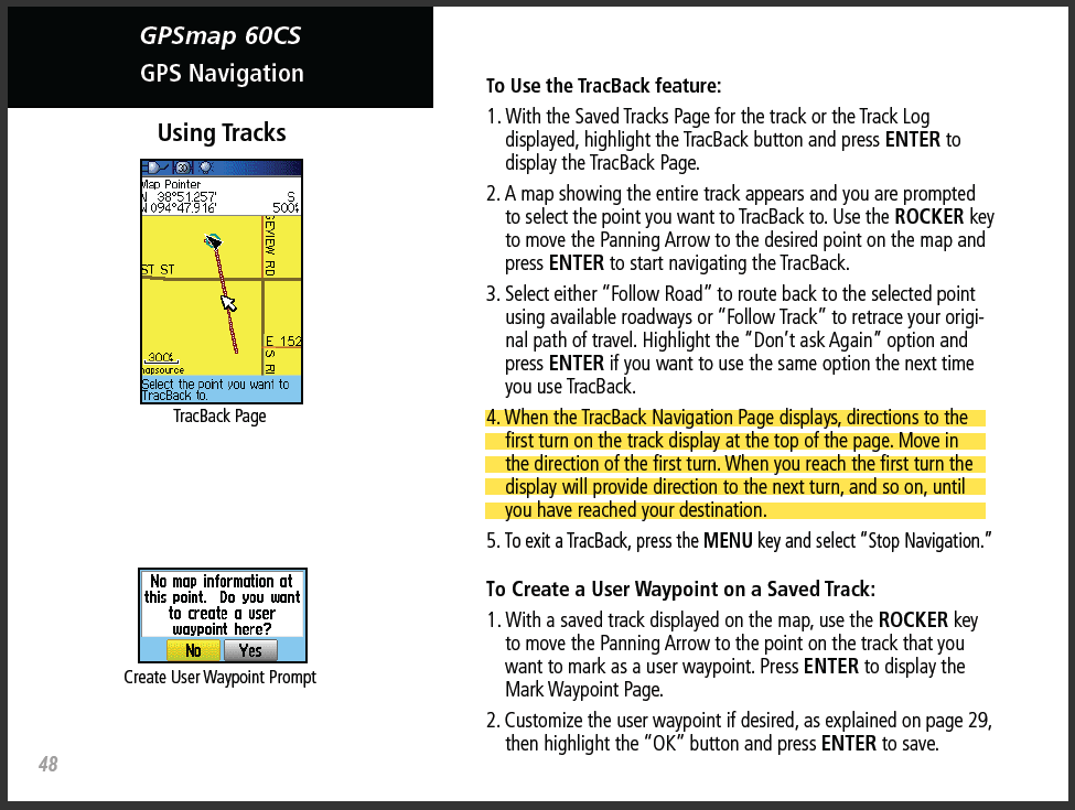
TracBack feature does not behave as with previous Garmin GPSr (see GPSMap 60cs), offering no functional value in current implementation. [wiki] [04FEB14] [3.60] [3.70] [3.80] [3.90] [4.10] [4.20] [4.30] [4.40]
- When activating a shortcut to toggle the screen lock via hardware button, the lock icon is not displayed in the lower left corner of the drawer screen. Only after touching the screen in the lower left corner is a warning displayed. [12FEB14] [2.70] [3.10] [3.20] [3.30] [3.50] [3.60] [3.80] 3.90] [4.10] [4.20] [4.30] [4.40] Garmin: "The lock icon is shown in the upper left hand corner above the drawer because it is being drawn in reference to the home screen and not on top of the drawer. When you unlock the screen again, the lock icon still remains drawn above the drawer in the top left corner because we’re not passing an update message to the home screen because it doesn’t currently have focus. Closing the drawer gives focus back to the home screen and the icon is removed. Fixing the lock icon not being removed after the screen has been unlocked with the drawer up is pretty much dead last in priority." [23JAN15]
-
When activating a shortcut to toggle the screen lock via hardware button, the lock icon in the lower left corner of the main menu screen is difficult or impossible to see if brightly colored wallpaper is enabled. Only after touching the screen in the lower left corner is a warning displayed. [12FEB14] [2.70] [3.10] [3.20] [3.30] [3.50] [3.60] [3.80] [3.90] [4.10] [4.20] [4.30] [4.40]
-
GPS Accuracy data field display value is commonly one unit higher than reported on GPS Dashboard. [example] [wiki] [18MAR14] [3.10] [3.60] [3.80] [3.90] [4.10]
[4.20] [4.30] [4.40] [4.60] [4.80] [4.90] [5.00] [5.10] [5.20] [5.30]
[5.40] [5.50] [5.60]
-
Saving the 'Current Track' requires several minutes to complete for some users. [wiki] [28JUL14] [3.50] [3.60] [3.70] [3.80] [3.90] [4.10]
-
Current Track application fails to restart track log recording while moving at slower pedestrian speeds (hiking, walking) when [Setup > Tracks > Auto Pause > On]. [10AUG14] [3.90] [4.10] [4.20]
-
Saving a portion of the current track and then viewing the saved track data in Track Manager fails to display several statistics and other totals for the saved portion (Time, Elapsed Time, Moving Avg, Calories). [21JAN15] [4.40]
-
Main Menu and some Application background images are garbled after
updating to firmware 5.20 [examples]
[wiki]
[17NOV17] [5.20] [Resolved 5.30]
-
[Setup > Routing > Avoidances] menu items that are unselected are
displayed with a large black block where an unchecked white space should be.
[example] [Gr]
[17OCT19] [5.50] [5.60]
-
[Setup > Display > Orientation Lock] is not
profile dependent, but should be, to maintain consistent behavior with
Montana series.(667) [17JAN20] [5.60]
Crash Reports
- Selecting [Calendar > {any date} > {any track}] randomly results in a device crash. [11MAY13] [2.60] 2.80] [3.20] [Resolved 3.30]
-
Selecting [Route Planner > {any route} > Elevation Plot] randomly results in a blank elevation plot window being displayed with all controls selectable, but none responding, requiring the user to remove the batteries and reboot the device. [11MAY13] [2.60] [2.70] [2.80] [Resolved 3.20]
-
Saving a portion of the current track and then selecting the saved track in the Track Manager list results in a crash. [15JUN13] [2.70]
-
Selecting [Track Manager > Sort > {Alphabetical or Most Recent} > {any track}] frequently results in a crash. [wiki] [video] [16JUN13] [2.70] [2.80] [2.90] [3.10] [3.20] [Resolved 3.30]
-
Selecting [Waypoint Manager > Close ('X') > Photo Viewer] results in a crash for some users. [wiki] [video] [16JUN13] [2.60] [2.70] [2.80]
-
Scrolling and/or selecting a
Favorites dashboard shortcut in the
Map application frequently causes the device to crash or freeze. [11JUL13] [2.80]
-
Most attempts to view the [Elevation Plot] in landscape mode with an active destination result in a device crash. [wiki] [27JUL13] [2.80] [3.10] [Resolved 3.20]
-
Repeatedly opening and closing any combination of applications (without interruption) from a main menu screen while the small data fields dashboard is active will eventually result in a device crash in as few as 9 cycles (Trip Computer) or 16 cycles (most others). [wiki] [03AUG13] [2.90] [3.10] [Resolved 3.20]
-
Any attempt to capture or view photos within
Camera application while a
custom map
is enabled for the GPSr current position results in a device crash. [wiki] [wiki] [05SEP13] [2.80] [2.90] [3.10] [3.50] [3.60] [3.70]
-
Selecting [Calendar > {any date} > {any track} > Map] randomly results in a device crash. [27SEP13] [3.20] [Resolved 3.30]
-
Selecting [{any map position} > Infobox] results in a crash. [27SEP13] [3.20] [Resolved 3.30]
-
Selecting [{any geocache from the Map application} > Infobox > Edit ('Flag') > OK] results in a crash. [27SEP13] [3.20] [Resolved 3.30]
-
Selecting [Current Track > Map > Infobox] results in a crash. [27SEP13] [3.20] [Resolved 3.30]
-
Selecting [{any photo from the Map application} > Infobox] results in a crash. [27SEP13] [3.20] [Resolved 3.30]
-
Selecting [Show Details] after receiving data from a Garmin chirp™ results in a crash. [wiki] [30SEP13] [3.20] [Resolved 3.30]
[Returned 5.50] [forum]
[5.60]
-
Attempting to view certain GGZ geocache descriptions crashes the Oregon
6x0. [Garmin DE] [GC39F9Z] [19OCT13] [3.30] [3.50] [3.60]
-
When navigating to the 'second' 'next stage' of a multi-cache after having
just 'found' a multi-cache with multiple stages, the Oregon 6x0 will freeze and/or
crash. [wiki]
[groundspeak] [11NOV13]
(832)
[3.10] [3.50]
[3.60] [3.80] [3.90] [4.10]
[4.20] [4.30] [4.40] [4.60] [4.80] [4.90] [5.00] [5.10] [5.20] [5.30] [5.40]
[5.50]
-
Selecting [Map > {any waypoint} > Infobox > Edit > Delete > Infobox] always results in a crash. [wiki] [16NOV13] [3.50] [Resolved 3.60]
-
Oregon
6x0 capacitive touch screen intermittently stops responding to user input, regardless of screen lock status, while power and user buttons continue to function as expected. Batteries must be removed from the device to restore proper operation. [wiki] [27JAN14] [3.60]
-
Oregon
6x0 with CustomSymbols and firmware v3.70 installed may crash frequently or fail to complete boot process leaving user with a potentially 'bricked' device. [wiki] [groundspeak] [01FEB14] [3.70] [3.80] [3.90] [Resolved 4.10]
-
Oregon
6x0 with CustomSymbols and firmware v3.80 installed may exhibit frequent lock-ups and/or crashes. [wiki] [groundspeak] [example 01] [14FEB14] [3.80] [3.90] [Resolved 4.10]
-
Oregon
6x0 with CustomSymbols and firmware v3.90 installed may exhibit frequent lock-ups and/or crashes. [01APR14] [3.90] [Resolved 4.10]
Hardware Failures
- Some users have reported hearing a squeaking sound from the sides of the frame while squeezing the GPSr firmly (when pressing the power/user buttons, etc). Removing the battery cover and adjusting the T6 Torx screws (nearest the squeak) counter clockwise 15° - 45° seems to reduce the severity
of the squeak. (Updated solution available in this
groundspeak post.)
-
Random shutdowns may be the result of a poor internal connection (due to excessive wear) between PCB and battery case caused by frequent use while mounted in high vibration environments (motorcycle, etc). [wiki] [02JAN14]
-
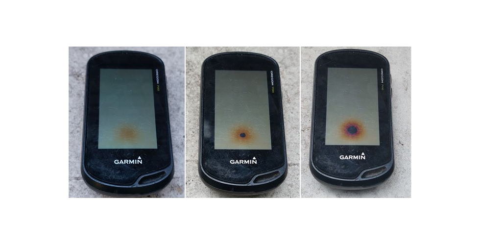
Exposure
to direct sunlight for an extended period of time may damage the screen. [example]
Missing Features
- Please include 'Custom Speed' settings for 'Auto Pause' feature, similar to Edge series GPSr. [wiki] [30JUL13]
-
Restore ability to see total number of found geocaches as was available in the geocaching dashboard with previous Oregon models. If not in the geocaching dashboard, include an additional data field. [wiki] [16SEP13]
-
Camera application is missing zoom control buttons available with similar camera equipped Garmin GPSr. [wiki] [27OCT13]
-
Large Data Field status bar display shows time only as HH:MM while previous GPSr display HH:MM:SS. [wiki] [20NOV13]
-
Oregon
6x0 Compass screen is absent the heading indicator displayed with all previous 'On The Trail' Garmin GPSr (GPSMap 60cs, GPSMap 62st, Colorado x00, Dakota 20, Oregon x00, Montana, etc). [07FEB14]
Requested Features
- Please update Sight 'N' Go application for units equipped with camera to (A) display a 'rolling tape' heading indicator along bottom of screen (profile or landscape), with the current heading displayed oversize in center of 'rolling tape' display, with a pointer icon (crosshair) centered on the screen, while (B) displaying the live camera image behind the 'rolling tape' Sight 'N' Go graphic. [15MAR13]
-
Please add a function to sound a user selected proximity alarm when within a user selected distance of a geocache. [Groundspeak] [04MAY13]
- The Elevation Plot application currently allows the user to view 'Elevation/Time', 'Elevation/Distance', 'Barometric Pressure', or 'Ambient Pressure' data. Please include option to view 'Temperature', 'Heart Rate', 'Cadence', 'Calories' and other data, when available. [04MAY13]
-
Please include [GLONASS On] and [GLONASS Off] option in Satellite application option menu. [11MAY13]
-
Please add option to lock screen automatically after {xxx} number of seconds. [wiki] [14MAY13]
-
Please include function to unlock screen via user defined screen gesture. [wiki] [14MAY13]
-
Please correct 'Distance to Next' and 'Time to Next' calculations to display the actual distance/time along a currently navigated track or route, not line of sight distance/time. [wiki] [wiki] [gpsReview] [ [22MAY13]
-
Please improve child waypoint management within the
GCUI, providing direct access to child waypoints for the active geocache, similar to the Monterra, regardless if stored as GPX, GGZ or GPI data. [wiki]
[groundspeak] [22MAY13]
-
Selecting a geocache from the Geocache Dashboard on the Oregon
6x0 is substantially less efficient compared to previous Garmin GPSr. Please restore speedy function by removing unnecessary and redundant steps. [wiki] [23MAY13]
-
Please include a QR Code viewer for 650/650t models. QR Codes are used for geocache hints and next stage coordinates. Make QR Code viewer accessible as a stand alone application and from the GCUI. [27MAY13]
-
Please include a compact Small Data Field dashboard with only two data fields. [wiki] [03JUN13]
-
Please add 'Distance From Start' data field for selected track point while reviewing a track. [wiki] [03JUN13]
-
Please include support for Beidou, Galileo, and QZSS satellite constellations. [wiki] [03JUN13]
-
Please add option to prevent alert messages (guidance text, etc) from waking the screen while battery save is enabled or screen is disabled by user. [wiki] [03JUN13]
-
Please add NMEA streaming via Bluetooth. [wiki] [05JUN13]
-
Please increase the response area for the dashboard hide/show chevron on the map page. [example] [11JUN13]
-
When selecting the lock/unlock icon on the
Status Page, the Oregon
6x0 frequently also sets the screen brightness to zero, as the two button positions are in such close proximity. Please improve this behavior. [wiki] [12JUN13]
-
Please add function to display geocache images (when present) in-line with geocache description text, allowing the user to select each image in the description for detailed viewing. [17JUL13] Garmin: "Use Geocaching with Photos to view geocache images. There are no plans to include inline images." [16AUG13]
-
Please enable ANT+ sensor Track Log data recording (using timed interval) when no satellite signal is present or satellite antenna is disabled (simulated GPS). [wiki] [22JUL13]
-
Please include function to Open/View/Edit/Save user created geocache logs stored on the GPSr. [02AUG13]
-
Please include an option to display Battery Level value as a percentage. [wiki] [12AUG13] Garmin: "Calculating battery charge level using NiMH cells isn't accurate enough to display a percentage. Some products may show NiMH level as a percentage, but doing so often gives a false impression of the battery level, so we won't. Displaying a percentage would not be accurate enough to prevent confusion or frustration of the user." [16AUG13]
-
Please include the [Where To?] application in the option menu proceeding the logging of a geocache. [wiki] [12AUG13]
-
Please enable 'Save & Go' function in [Mark Waypoint] application via press and hold [Save]. [wiki] [17AUG13]
-
Please incorporate Ambient Pressure and Barometric Pressure data (when enabled) into recorded track data. [23AUG13]
-
Allow user to show/hide dashboards in Map application by dragging dashboard chevron to/from perimeter of the map screen. [wiki] [11SEP13]
-
Please adjust firmware to prevent the indexing of duplicate waypoints. [wiki] [06OCT13]
-
Improve Track Manager list function to include a 'Show/Hide' toggle with each track in the list, similar to Map Selection Menu. [09OCT13]
-
Please include a [Hide All Tracks] entry that is always visible at the beginning of the Track Manager List. [09OCT13]
-
Please implement routing controls to allow selection of current route color, width and transparency. [wiki] [wiki] [16OCT13]
-
Please include option to sort waypoints by date (newest/oldest). [wiki] [25OCT13]
-
When creating and navigating a route between geocaches, the user must exit the route to log a geocache. Please update firmware to recognize geocache waypoints in an active route to allow user to decide when the geocache waypoint has been found and log the geocache before moving on to the next waypoint. [30OCT13]
-
Trip Odometer: Add multiple Trip Odometers with ability to use and reset them individually. [wiki] [06NOV13]
-
Please include creation date and time stamp information where track log information is displayed. [wiki] [27NOV13]
-
Please allow separate configuration for interface language and keyboard language. [wiki] [15DEC13] Garmin: "In a way, this already exists. You can hit the menu button when the keyboard is displayed, and change the keyboard language to any of the supported ones. It will remain this way until you manually change it again or the unit restarts." [23JAN15]
-
Improve Geocache List Tab performance by allowing user to decide when the list is refreshed. [16DEC13]
-
Please include 'Automotive Mode' in the map orientation cycle accessed by touching the north arrow on the map screen. [17DEC13]
-
Please configure Oregon
6x0 to prompt user to 'Choose alternate routing activity or select new destination' when routing errors occur. [wiki] [Bug 71] [31JAN14]
- Please add
Compass Mode settings to shortcut creation menu. [Groundspeak] [11FEB14]
-
Please include functionality to export/share GPSr Calendar database with external software. [Garmin DE] [23FEB14]
-
Please add data fields for 'minutes per mile' and 'minutes per kilometer'. [wiki] [11MAY14]
-
Please enhance contrast/readability for Satellite Signal Strength bars. [wiki] [17JUN14]
-
Please introduce a simple notepad
page that allows the user to create, edit and save geo-tagged alpha-numeric
notes for future reference. [Gr]
[17OCT19]
END

