Rino 700
| 1. | Attempting to add Pages to Main Menu can result in a corrupted menu being displayed. [example] | [220] [240] [250] | |
| 2. | The Flag icon continues to be displayed on the Radio page Status Bar (indicating the Rino remains ready to transmit position information) after disabling 'Send Position' and/or 'Allow Polling' in Radio Setup. (similar to 75x Bug 9) | [220] [240] [250] | |
| 3. | The Radio icon continues to be displayed on the Radio page Status Bar (indicating the Rino radio is powered on) even after disabling the radio. (similar to 75x Bug 18) | [220] [240] [250] |
Rino 75x
| 1. | Unable to load GCLive data for geocaches already present on the GPSr or microSD card (GPX/GGZ) regardless if related GPX/GGZ files are disabled in [Geocaching > Filters > Geocache Files]. | [370] [380] [400] [410] [420] [430] [440] [450] [480] [490] [510] [530] | |
| 2. | With [Setup > Accessibility > Scroll Controls > On], the scroll control icons interfere with the search and filter icons in the Geocache List tab, providing unpredictable results and a poor user experience. | (225) | [370] [380] [400] [410] [420] |
| 3. | Performing a press-and-hold on the active Map screen dashboard provides an incomplete list of available dashboards to choose from. | [370] [380] [400] [410] [420] [430] [440] [450] [480] [490] [510] [530] | |
| 4. | With [Setup > Position Format = hddd°mm.mmm'] selected, coordinates are actually displayed as hddd°mm.mmmm'. (Please update this menu selection to read hddd°mm.mmmm') (see 75x Feature Request 2) | (226) | [370] [380] [400] [410] [420] |
| 5. | When navigating to 'Next Stage' coordinates for a geocache that does not exist in any GPX or GGZ file, the Geocaching page no longer displays the description for the parent geocache, which often includes critical information required to complete the search. [garmin de] | (831) | [370] [380] [400] [410] [420] |
| 6. | Selecting the Trash icon in the Activity Tab of the Current Activity page and clearing the current tracklog recording returns the user to the Main Menu Home page, not the previously open Activity Tab in the Current Activity page. This behavior is unlike the Oregon 6x0, Montana 6x0, and GPSMAP 66, all of which return the user to the previously open Activity Tab. | (227) | [370] [380] [400] [410] [420] [430] [440] |
| 7. |
Geocaching quick filter selections are not always properly retained.
[see
Oregon 6x0 Bug 11,
Oregon 7x0 Bug 44,
and
eTrex Touch Bug 8]
|
[370] [380] [400] [410] [420] [430] [440] [450] [480] [490] [510] [530] | |
| 8. | Weather Forecast tab frequently fails to load forecast information, instead displaying 'Waiting for data' indefinitely, even while Weather Radar tab data and GCLive data functions perform properly. | [370] [380] [400] [410] [420] | |
| 9. | The Green Flag icon continues to be displayed on the Radio page Status Bar (indicating the Rino remains ready to transmit position information) after disabling 'Send Position' and/or 'Allow Polling' in Radio Setup. This is not consistent with previous Rino radio operation. (similar to 75x Bug 18) | (231) | [370] [380] [400] [410] [420] |
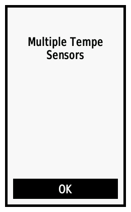
| 10. | Rino 75x is unable to connect to ANT+ sensors any time two or more similar sensors are within range. [example] | (230) | [370] [380] [400] [410] [420] [430] |
| 11. | Pressing the 'Call' or 'PTT' buttons while a USB power supply is connected results in erroneous 'Mass Storage' and 'Device Shutdown' prompts, interfering with and preventing desired radio operation. | (232) | [370] [380] [400] [410] [420] |
| 12. |
When used in Landscape mode,
the position icon (vehicle) on the map page is displayed 90° from actual
device bearing. [see
Oregon 7x0 Bug 27:
example 1, example
2, example
3, example
4,
forum]
2. Select any vehicle icon other than the default small/large blue triangles and position yourself facing due NORTH. 3. Do not change your physical position or bearing during the entire process. 4. Hold the GPSr directly in front of you, screen perpendicular to the ground, in portrait orientation. 5. The position icon on the map will show you pointing North on the map. 6. Slowly begin to rotate the GPSr to the left 90 degrees (like turning a steering wheel on a car). 7. Somewhere around 60 degrees, the map will flip from portrait to landscape mode. 8. The position icon will now be pointing EAST (toward the Garmin logo on the bottom of the GPSr). 9. Slowly rotate the GPSr to the right 90 degrees. 10. After the map page flips from landscape to portrait, the icon will again be facing NORTH. 11. Slowly rotate the GPSr to the right another 90 degrees. 12. Somewhere around 60 degrees, the map will flip from portrait to landscape mode. 13. The position icon will now be pointing WEST (toward the Garmin logo on the bottom of the GPSr). 14. During both events, you never change your physical heading, but the position icon does. |
(200) | [370] [380] [400] [410] [420] |
| 13. | Selecting [Share Wirelessly > Send > Use ANT/Bluetooth] correctly displays a list of available data types to choose from (the first time). Selecting [Back > Use ANT/Bluetooth] from this menu results in random tracks being displayed instead of the expected available data type selection list that was previously displayed. | (235) | [370] [380] [400] [410] [420] |
| 14. | With [Setup > Routing > Activity = Prompted], selecting [Where To? > Contacts > {any contact} > Go > Direct Routing] always fails to start any navigation. (may be related to 75x Crash 2) | (234) | [370] [380] [400] [410] [420] |
| 15. | For the full duration of a power on and/or power off sequence with the GMRS radio enabled, the speaker frequently emits a static sound (at full volume, regardless of system or radio volume settings) that is very unpleasant and disruptive. | [370] [380] [400] [410] [420] [440] | |
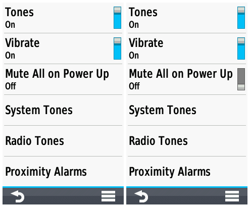
| 16. | The [Setup > Tones > Mute All on Power Up] selection is displayed without the 'on/off toggle switch' when opened from the Radio page option menu [Radio > Menu > Tones Setup], and pressing this menu option has no affect other than to highlight the selection, which can only be cleared by exiting the menu. [example] | (233) | [370] [380] [400] [410] [420] |
| 17. | While receiving weather radio broadcasts with Weather Alerts enabled and [Setup > Radio > Advanced Setup > Weather Alert = {any selection}], opening the Weather page and selecting the Weather Alert Tab always reports 'No weather alerts detected...' | (236) | [370] [380] [400] [420] |
| 18. | The Radio icon continues to be displayed on the Radio page Status Bar (indicating the Rino radio is powered on) even after disabling the radio. This is not consistent with previous Rino radio operation. (similar to 75x Bug 9) | (237) | [370] [380] [400] [410] [420] |
| 19. | Weather Radio frequently selects channels with no radio activity over channels with radio activity when set to 'Auto'. | [370] [380] [400] [410] [420] [430] [440] [450] [480] [490] [510] [530] | |
| 20. | Map page 'Detail' is always reset to 'Least' after viewing Weather page Alerts map ('Least' is the default detail level for this page, should not affect other map pages). | [370] [380] [400] [410] [420] | |
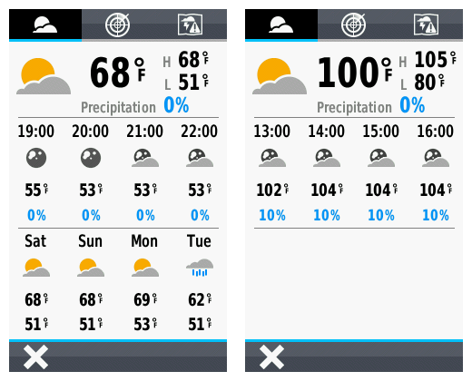
| 21. | Weather page may display hourly forecast only, without including daily forecast information. [example] | [420] [430] [440] [450] [480] [490] [510] [530] | |
| 22. | Contact Tracks saved to the Rino 75x are displayed in the Favorite Track list only after the device is restarted. | (254) | [420] [430] [440] [450] [480] [490] [510] [530] |
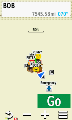
| 23. | Selecting [Track Manager > Contact Tracks > {Select Contact} > View Map] always results in unrealistic Info Box distance values being displayed (potentially to 'null island'). [example] | (253) | [420] [430] [440] [450] [480] [490] [510] [530] |
| 24. | While programming a chirp device, after choosing a waypoint or a geocache, the map page is frequently displayed with the 'Go' button instead of the 'Send' button. | [370] [380] [400] [410] [420] [430] [440] | |
| 25. | Geocaches loaded via 'Share Wirelessly' do not include child waypoints. | [420] [430] [440] [450] [480] [490] | |
| 26. | Starting the Rino 75x with geocache proximity alerts enabled while several hundred geocaches are loaded via GGZ files frequently results in a substantially longer boot sequence duration. | [420] [430] | |
| 27. | Geocache 'Child Waypoints' are always displayed by 'Code', and never by 'Name', regardless of the user selection in Geocaching Setup. | [420] [430] [440] [450] [480] [490] [510] [530] | |
| 28. | After beginning navigation to a geocache child waypoint, having just selecting the child waypoint from the Geocache page 'Additional Waypoints' menu, the user no longer has access to the parent geocache information from the Geocaching page. Child Waypoints (or 'Additional Waypoints') should always be treated as 'Via Points' when selected from the 'Additional Waypoints' menu. | [420] [430] [440] [450] [480] [490] [510] [530] | |
| 29. | Custom Waypoint Symbols loaded to the device with names including a 'Hot Spot' are ignored and not displayed. | (868) | [370] [380] [400] [410] [420] [430] [440] [450] [480] |
| 30. | Course (CDI) bearing line remains positioned over the course line during off-course navigation. This behavior is inconsistent with many prior and current generation Garmin GPSr. [garmin.de] | [370] [380] [400] [410] [420] [430] [440] [450] [480] [490] [510] [530] | |
| 31. | Adventures may randomly lose data and/or disappear from the device, and the user may find Adventure data files moved and/or deleted between microSD card and internal memory. | [370] [380] [400] [410] [420] [430] [440] [450] [480] [490] [510] [530] | |
| 32. | Garmin Adventure Photos loaded to the microSD card are not properly indexed or displayed when sorted by 'Most Recent' in 'Photo Viewer' page, but are properly displayed when viewed from Adventure Content page. | [370] [380] [400] [410] [420] [430] [440] [450] [480] [490] [510] [530] | |
| 33. | Geocaches listed in the Adventure Content Menu may not appear when selected. | [370] [380] [400] [410] [420] [430] [440] [450] [480] [490] [510] [530] | |
| 34. | Returning to the home page for a selected Adventure after viewing any listed content results in the map displaying the users current location instead of the Adventure location. | [370] [380] [400] [410] [420] [430] [440] [450] [480] [490] [510] [530] | |
| 35. | With Trip Recording configured for 'During Activity' and Activity Recording paused or inactive, the Recording Controls Activity Plot Tab accumulates 'Total Ascent' data while the Information Tab continues to display no change for the same value. | [480] [490] [510] [530] | |
| 36. | Map page waypoint name text does not honor display mode changes. User must disable then enable text display in Map Setup to force correct text display for current display mode. See Montana 7x0 forum post for details. | [440] [450] [480] [490] [510] [530] | |
| 37. |
While viewing waypoints listed in
any Adventure Content menu;
|
[490] [510] [530] |
Rino 700
| 1. |
Rino 75x
| 1. | When navigating to the 'second' 'next stage' of a multi-cache after having just 'found' a multi-cache with multiple stages, the GPSr will freeze and/or crash. [groundspeak] | [370] [380] [400] [410] [420] | |
| 2. | With [Setup > Routing > Activity = Prompted], selecting [Where To? > Contacts > {any contact} > Go > {any Activity other than Direct}] always results in a device freeze followed by a crash. (may be related to 75x Bug 14) | (234) | [370] [380] [400] [410] [420] |
Rino 700
| 1. |
Rino 75x
| 1. |
Rino 700
| 1. | Please improve child waypoint management within the Geocaching User Interface, providing direct access to child waypoints for the active geocache, similar to the Monterra. [groundspeak] |
Rino 75x
| 1. | Please improve child waypoint management within the Geocaching User Interface, providing direct access to child waypoints for the active geocache, similar to the Monterra. [groundspeak] | [420] | |
| 2. | The Favorites Dashboard is not available in the Map, Compass or Trip Computer pages, which is not consistent with previous Garmin GPSr. [Gr] | ||
| 3. | Camera application is missing zoom control buttons available with similar camera equipped Garmin GPSr. | ||
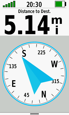
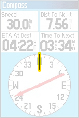
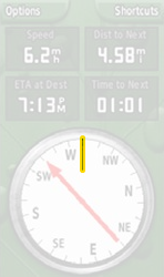
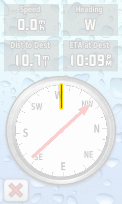
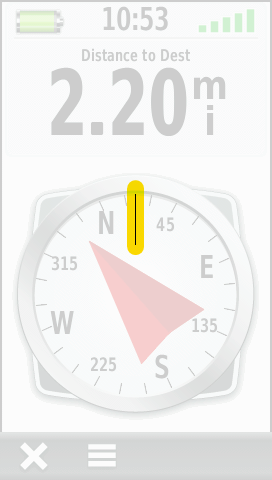
| 4. | Rino 75x Compass screen is absent the heading indicator displayed on previous Garmin 'Outdoor Recreation' GPSr (GPSMap 60cs, GPSMap 62st, Colorado x00, Dakota 20, Oregon x00, Montana, etc). |
Rino 700
| 1. |
Rino 75x
| 1. | Please add a 'Refresh' icon to the geocache logs display that, when pressed, loads the next 5 logs for the active geocache, and can be repeated as frequently as desired to load an additional 5 logs each time. [example] | ||
| 2. | Please include both hddd°mm.mmm' and hddd°mm.mmmm' options in [Setup > Position Format]. Currently only hddd°mm.mmm' is available even though coordinates are displayed as hddd°mm.mmmm' (see 75x Bug 4). [groundspeak] | (777) | |
| 3. | Please include function to enable review and editing of geocache log notes on the device. [Gr] | ||
| 4. | Please include option to auto-upload logs to geocaching.com as 'Field Notes', allowing the user to edit them at a later time before publishing as a log. [Gr] | ||
| 5. | Please introduce a simple notepad page that allows the user to create, edit and save geo-tagged alpha-numeric notes for future reference. [Gr] | ||
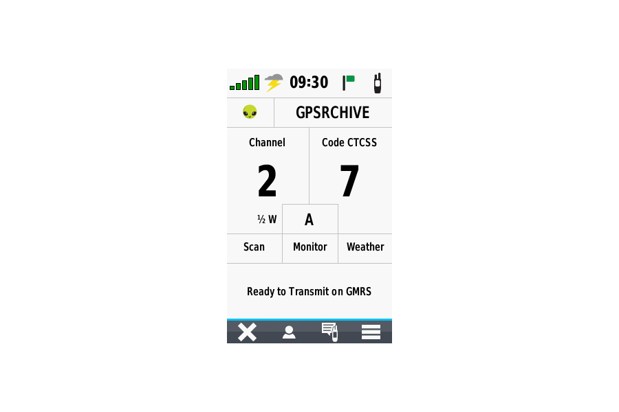
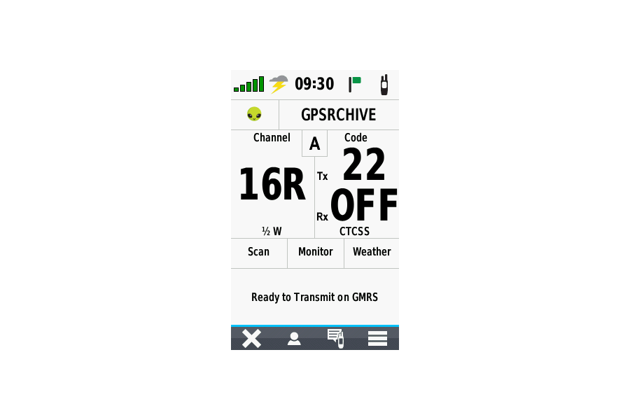
| 6. | When changing the radio channel or squelch code in the Radio page the user must first touch the large channel indicator and then touch the +/- buttons to select the desired channel. To complete the operation, the user must then move down to the bottom of the screen and touch the small back arrow. It would be much more intuitive if the user could also just touch the large channel indicator again to exit the function, similar to the action taken to enter the function. | (229) | [420] |
| 7. | The [Setup > Recording > Advanced Setup > Output Format] option always defaults to Activities [FIT], requiring each user to manually configure their GPSr to record track logs in [GPX] format. This is a huge nuisance as the [GPX] format has been the default option for 20+ years, and [FIT] files are only useful with Garmin Connect, which is only used primarily with Fitness products. Please correct this default behavior immediately! | ||
| 8. | Please add 'Two Channel' (A/B) option in Radio Setup to allow users quick access to two unique channel configurations with a single touch of screen. [example] | ||
| 9. | Please include option to edit/use separate Tx and Rx codes for active channel ('A' and 'B'). [example] | ||
| 10. | Please add a 'Favorite Channels' function that allows the user to save multiple favorite channel configurations and quickly recall them from the Main Radio page. | ||
| 11. | Add functionality to decode and display Morse code messages as they are received over GMRS (perhaps in Activity Panel) as well as convert and transmit user entered text as Morse code over GMRS. | ||
| 12. | The Elevation Plot application currently allows the user to view 'Elevation/Time', 'Elevation/Distance', 'Barometric Pressure', or 'Ambient Pressure' data. Please include option to view 'Temperature', 'Heart Rate', 'Cadence', 'Calories' and other data, when available. | ||
| 13. | Please add 'Download Geocaches' selection to Map page option menu. | ||
| 14. | The Geocache Proximity Alert feature currently only allows the user to 'Dismiss' an alert. Please also include the option to 'Begin Navigation' to the displayed geocache. [Gr] | ||
| 15. | Please include 'Most Recent' selection in Waypoint Manager 'Sort' option menu, similar to the existing Track Manager sort option menu. [Gr] | ||
| 16. | Please add an option allowing the user to configure the total number of geocaches used to populate the Geocache List. | ||
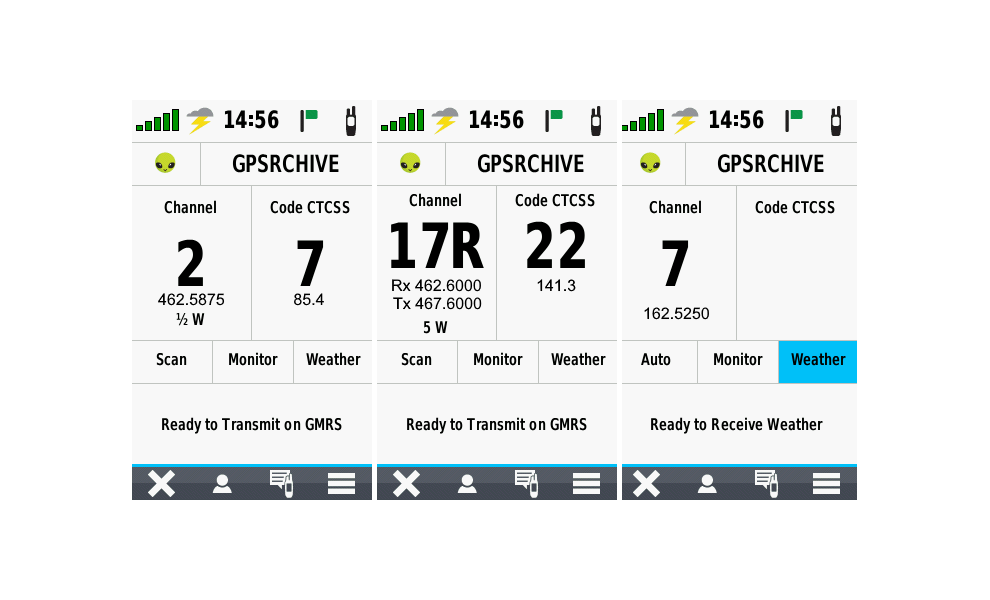
| 17. | Please improve Radio page functionality to display frequency values for channels and CTCSS tones. [examples] | ||
| 18. | Please include an option to enable/disable the Barometric Altimeter (similar to Montana 7x0). |