Tread 2
Powersport
010-02972-00
Tread 2
Overland
010-03021-00
Tread 2
SxS
010-03021-01
5.3" x 3.0" (13.3 x 7.5 cm)
6.8" x 4.2" (17.2 x 10.8 cm)
|
Tread 2 Powersport 010-02972-00 |
Tread 2 Overland 010-03021-00 |
Tread 2 SxS 010-03021-01 |
|
| General | |||
| Unit Dimensions | 6.1” x 3.5” x 1.0” (15.6 x 8.9 x 2.5 cm) | 8.1” x 5.4” x 1.1” (20.6 x 13.7 x 2.8 cm) | |
| Weight | 12.0 oz (340 g) | 22.1 oz (627 g) | |
| Display Size |
6.0" (15.3 cm) diagonal 5.3" x 3.0" (13.3 x 7.5 cm) |
8.0" (20.3 cm) diagonal 6.8" x 4.2" (17.2 x 10.8 cm) |
|
| Display Resolution | 1280 x 720 pixels | 1280 x 800 pixels | |
| Display Type | High brightness glass multi-touch HD color TFT with white backlight | ||
| Touchscreen | Yes | ||
| Floats | No | ||
| Water / Dust Rating | IP67 | ||
| Drop Rating | MIL STD 810 | ||
| Battery | Internal Rechargeable Lithium-ion | ||
| Battery Life | up to 7 hours (50% backlight) | up to 6 hours (50% backlight) | |
| Power Input | 12 to 18 VDC | 12 to 24 VDC | |
| Operating Temperature | 5° to 131°F (-15° to 55°C) | -4° to 131°F (-20° to 55°C) | |
| Charging Temperature | 32° to 113°F (0° to 45°C) | ||
| Magnetic Mount | No | Yes | |
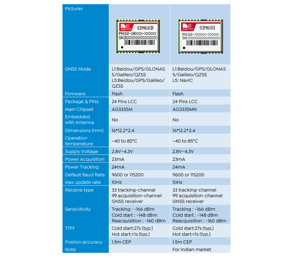
| GPS Antenna | Internal Patch | ||
| GPS Chipset | AG3335M | ||
| High Sensitivity GPS Receiver | Yes | ||
| Multi-GNSS | |||
| Multi-Band | |||
| GNSS Network | GPS + Galileo + BeiDou | ||
| Interface | USB-C | ||
| Memory | |||
| Internal Memory | 56GB | ||
| Accepts Data Card | Yes (microSD, Max 256GB, Class 2 to 10) | ||
| Custom POIs | Yes | ||
| Waypoints | 10,000 | ||
| Routes | ∞ | ||
| Tracks | 2,000 | ||
| Maps | |||
| Preloaded Maps | Street Maps | ||
| Topographical Maps | |||
| US Public Land Boundaries | |||
| Private Land Parcel Maps | |||
| USFS Roads and Trails | |||
| MVUM Maps for Motorcycle, ATV, SxS and Full Size 4x4 | |||
| High Definition 3D Terrain Maps | |||
| Outdoor Maps+ | Yes | ||
| Ability to Add Maps | |||
| Garmin Custom Maps | 400 | ||
| Garmin BirdsEye Maps | 1,000 | ||
| Sensors | |||
| Electric Compass | Yes | ||
| Barometric Altimeter | |||
| UV Sensor | No | ||
| Microphone | |||
| Outdoor Recreation Features | |||
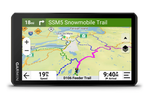
| Point-To-Point Navigation | |||
| Navigate-A-Track Navigation | |||
| Turn-By-Turn Trail Navigation | |||
| Navigation Features | |||
| Garmin Real Directions Landmark Guidance | |||
| TripAdvisor Traveler Ratings | |||
| Route Shaping Through Preferred Cities/Streets | |||
| Traffic Information | |||
| Lane Assist With Junction View | |||
| Speed Limit Indicator | |||
| Driver Alerts for Sharp Curves, School Zones, Red Light and Speed Cameras, and More | |||
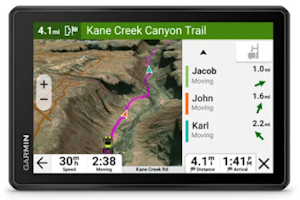
| Adventure Features | |||
| Glove-Friendly Touchscreen | |||
| Pair with Compatible inReach Devices | |||
| Pair with Garmin PowerSwitch | |||
| Compatible with Group Ride Radio | |||
| Group Ride Mobile via Tread App | |||
| Compatible with Handlebar Controller | |||
| Track Recorder (Breadcrumb Trail) | |||
| IOverlander Points of Interest | |||
| Ultimate Public Campgrounds | |||
| Pitch and Roll Gauges | |||
| BirdsEye Satellite Imagery | |||
| Motorcycle Features | |||
| Control Music and Media from Smartphone or MP3 Player | |||
| Sunlight Readable and Weather Resistant | |||
| Garmin Adventerous Routing | |||
| Elevation Profile | |||
| Round Trip Routing | |||
| Custom Map Support | |||
| Wireless ANT+ Technology | |||
| RV Features | |||
| Specialized Routing for Size and Weight of Vehicle | |||
| Speed Limit Changes | |||
| Easy Route Planner with GPX File Sharing | |||
| Wireless | |||
| Camera Support | BC 50 | ||
| Bluetooth Calling | Yes | ||
| Wi-Fi Updates | |||
| Garmin Connect App | No | ||
| Garmin Explore App | |||
| Garmin Tread App | Yes | ||
| Smart Notifications | |||
| Live Tracking | Yes (via Group Ride Radio or Tread App) | ||
| Wireless Unit to Unit Transfer | Yes (via Group Ride Radio) | ||
| Connect IQ Applications | No | ||
| Live Weather | Yes | ||
| Dog Tracking | |||
| inReach Remote | |||
| VIRB Remote | No | ||
| XERO Locations | |||
| RINEX Logging | |||