Common Issues- If your Garmin Monterra is exhibiting bad behavior you do not see listed here, please
post a new thread about your experience and send a detailed error report to Garmin, as outlined below.
- If you do see your issue listed here, please send your detailed error report to Garmin! They need to hear from all users.
- Please handle all feature requests similarly:
Post a new thread if not already listed, and
send a copy to Garmin.
-
If you see your request is already listed,
copy and paste it to Garmin! The more frequently they see the same request, the more likely they are to include it in a future update.
Error Reporting
- Please report all software bugs, glitches, crash reports, and feature requests in the
Monterra discussion forum.
-
Try to include as much detail as possible when describing each issue you are experiencing, including profile settings, maps installed/enabled, keystrokes used, etc.
-
Send a copy of your post to
product.support@Garmin.com
and include:
- a copy of the
GarminDevice.xml file located in the [GPSr]\Internal Storage\Garmin\ directory.
-
any
*.gpx files associated with the crash or bug from the [GPSr]\Internal Storage\Garmin\GPX\ or [microSD]\Garmin\GPX\ directories.
-
any
*.ggz files associated with the crash or bug from the [GPSr]\Internal Storage\Garmin\GGZ\ or [microSD]\Garmin\GGZ\ directories.
Status
- RED: Issue/Feature Request has been reported to Garmin, and is pending response.
-
ORANGE: Garmin has acknowledged a Reported Issue/Feature Request and may be working on a solution.
-
GREEN: Issue has been resolved and no longer exists. Requested Feature has been implemented.
Categories
-
Bugs (18/01/32): Software issues that result in a system failure or adversely affect intended functionality.
-
Crash Reports (01/00/02): Bugs resulting in unintentional hanging, freezing, resetting or powering down.
-
Hardware Failures (00/00/00): Physical issues and/or failures that limit or inhibit intended function.
-
Missing Features (06/00/01): Feature is available on a similar Garmin GPSr unit such as the Montana or eTrex.
-
Requested Features (03/00/00): Request for functionality not present with current firmware version.
Bugs
- GOA compass is off by as much as 60° (regardless of calibration). [groundspeak] [18NOV13] [2.20_1.15.00] [2.20_1.16.00] [Resolved 2.20_1.18.00]
-
Found geocaches are not marked as found in the geocache list. [03DEC13] [2.20_1.15.00] [2.20_1.16.00] [2.20_1.18.00] [2.20_1.19.00] [2.90_1.20.00] [3.20_1.21.00] [3.50_1.23.00] [3.50_1.24.00] [3.50_1.26.00]
-
After logging a geocache as found at the geocache location, that same geocache is still displayed as the next nearest geocache on the Geocaching Dashboard. (03DEC13] [2.20_1.15.00] [Resolved 2.20_1.16.00]
-
The Geocaching Dashboard does not update the 'nearest geocache' while enabled in Map application. [wiki] [03DEC13] [2.20_1.15.00] [2.20_1.16.00] [Resolved 2.20_1.18.00]
-
The Geocache Dashboard displays the nearest geocache while navigating to any other geocache. [03DEC13] [2.20_1.15.00] [Resolved 2.20_1.16.00]
-
While navigating to a geocache, the Geocaching Dashboard intermittently fails to provide access to the geocache description, hint, logs or logging interface, when selected. [wiki] [video] [video 2] [03DEC13] [2.20_1.15.00] [2.20_1.16.00] [2.20_1.18.00] [Resolved 2.20_1.19.00]
-
HTML code is not stripped from geocache logs or descriptions, making them difficult to read. [example 01] [example 02] [03DEC13] [2.20_1.15.00] [2.20_1.16.00] [2.20_1.18.00] [Resolved 2.20_1.19.00]
-
Geocache names and descriptions are truncated and displayed incomplete. [GC2EPVV] [GC46E8C] [GC46AYK] [wiki] [03DEC13] [2.20_1.15.00] [2.20_1.16.00] [Resolved 2.20_1.18.00]
-
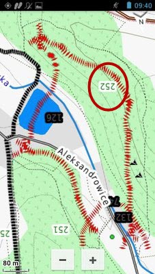
The names of some map details are displayed upside down. [example 01] [example 02] [03DEC13] [2.20_1.15.00] [2.20_1.16.00] [Resolved 2.20_1.18.00]
-
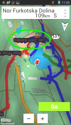
Map application is unable to properly display common map details, rendering many maps unusable. [wiki] [03DEC13] [2.20_1.15.00] [2.20_1.16.00] [2.20_1.17.00] [2.20_1.18.00] [2.20_1.19.00] [2.90_1.20.00] [3.20_1.21.00] [3.50_1.23.00] [3.50_1.24.00] [3.50_1.26.00]
-
The bearing line on the Map application does not update from the starting position while navigating to any destination with direct routing selected. [03DEC13] [2.20_1.15.00] [Resolved 2.20_1.18.00]
-
GOA is very slow to respond (>10 seconds) between selecting a desired [Where To?] destination and displaying the map screen with [Go] button. [05DEC13] [2.20_1.15.00] [2.20_1.16.00] [Resolved 2.20_1.19.00]
-
BirdsEye imagery is blurry at higher zoom levels, regardless of detail level selected. [05DEC13] [2.20_1.15.00] [2.20_1.16.00] [2.20_1.17.00] [2.20_1.18.00] [Improved 2.20_1.19.00] [2.90_1.20.00] [3.20_1.21.00] [Improved 3.50_1.23.00]
-
When powered off, and later powered on, while installed in a powered Garmin Rugged Mount, GOA will not complete GPS initialization or achieve satellite lock until the GPSr is removed from the mount. [05DEC13] [2.20_1.15.00] [2.20_1.16.00] [Resolved 2.20_1.18.00]
-
Barometric Pressure is always reported as a whole number (no tenths or hundredths) within GOA when units are set to 'inHg', while external applications always report useful values to two places after the decimal. [05DEC13] [2.20_1.15.00] [2.20_1.16.00] [Resolved 2.20_1.18.00]
-
Map settings are not always updated after changing active profile. [groundspeak] [05DEC13] [2.20_1.15.00] [2.20_1.16.00] [2.20_1.18.00] [2.20_1.19.00]
-
GOA is frequently unable to find or maintain reliable connection to ANT+ sensors. [05DEC13] [2.20_1.15.00]
-
Navigating any route > 50 miles in length results in 'Time To Destination' data field displaying '01:00' and is never updated. [groundspeak] [05DEC13] [2.20_1.15.00]
-
Waypoint labels are not displayed on the map screen. [groundspeak] [05DEC12] [2.20_1.15.00] [2.20_1.16.00] [2.20_1.18.00] [2.20_1.19.00]
-
Map screen rotates erratically and randomly while stationary or in motion when set to 'Track Up'. [05DEC13] [2.20_1.15.00] [2.20_1.16.00] [2.20_1.18.00] [2.20_1.19.00]
-
The 'Large Data Fields' dashboard does not properly render all data fields. [example] [05DEC13] [2.20_1.15.00] [2.20_1.16.00] [2.20_1.18.00] [Resolved 2.20_1.19.00]
-
GOA does not honor time format settings. [wiki] [10DEC13] [2.20_1.15.00] [Resolved 2.20_1.16.00]
-
Incorrect or no data displayed in Navigation Data Fields while navigating a track. [10DEC13] [2.20_1.15.00]
-
GOA does not honor unique routing settings when switching profiles while Map application is open. [10DEC13] [2.201.15.00] [2.20_1.16.00] [2.20_1.18.00] [2.20_1.19.00]
-
Selecting [Where To? > Recent Finds > Menu > Clear List] does not clear recent finds list. [10DEC13] [2.20_1.15.00] [Resolved 2.20_1.16.00]
-
While in Landscape mode, home screens to the right overlap current home screen and are partially visible under the favorites bar. [10DEC13] [2.20_1.15.00] [2.20_1.16.00] [2.20_1.18.00] [2.20_1.19.00] [2.90_1.20.00]
-
Power cycling the Monterra off/on with Position Format UTM UPS selected results in Satellite Widget and Mark Waypoint applications displaying current position as 'UTM 11 T 0500000 0000000', and can be resolved by changing Position Format to Lat/Lon. [10DEC13] [2.20_1.15.00] [2.20_1.16.00] [Resolved 2.20_1.18.00]
-
GOA is unable to properly search EU map addresses and intersections from [Where To?]. [10DEC13] [2.20_1.15.00] [Resolved 2.90_1.20.00]
-
Track files transferred to the Monterra with track color set to 'Black' are displayed as 'Cyan' in Track Manager application. [10DEC13] [2.20_1.15.00] [2.20_1.16.00] [2.20_1.17.00] [2.20_1.18.00] [2.20_1.19.00] [Resolved 2.90_1.20.00]
-
Changing screen orientation (portrait > landscape or landscape > portrait) after panning Map application to a new location results in map resetting to current position. [10DEC13] [2.20_1.15.00] [2.20_1.16.00] [Resolved 2.20_1.18.00]
-
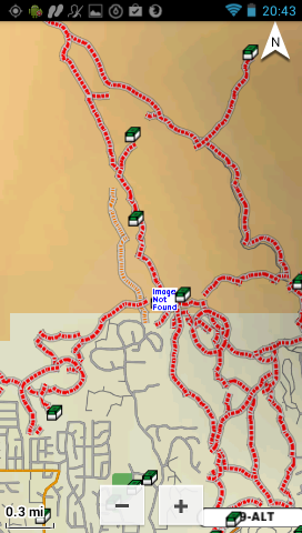
Earth Cache icons are displayed as 'Image Not Found'. [example 01] [wiki] [15DEC13] [2.20_1.15.00] [2.20_1.16.00] [Resolved 2.20_1.18.00]
-
Selecting the Map application Info Box when multiple map items are available, and then selecting the desired map item from the drop down menu should open an information screen for the selected map item. Instead, the selected map item simply replaces the map item originally displayed in the Info Box, providing no real function or benefit. [15DEC13] [2.20_1.15.00] [2.20_1.16.00] [2.20_1.18.00] [2.20_1.19.00] [2.90_1.20.00]
-
Creating a geocache filter 'Hide All' where all geocache types are deselected results in all geocaches being displayed. [15DEC13] [2.20_1.15.00] [2.20_1.16.00] [2.20_1.18.00] [2.20_1.19.00] [2.90_1.20.00] [Resolved 3.20_1.21.00]
-
Geocache Filters are not retained. [wiki] [17DEC13] [2.20_1.15.00] [2.20_1.16.00] [2.20_1.17.00] [2.20_1.18.00] [Resolved 2.20_1.19.00]
-
[Settings > Garmin > Routing > Navigation Voice > None] is not retained after a power cycle. [wiki] [18DEC13] [2.20_1.16.00] [Resolved 2.20_1.17.00]
-
WAAS satellites are identified by PRN number and are not displayed in the satellite constellation, while other satellites are displayed and identified by NMEA number. [PRN 133] [PRN 135] [PRN 138] [18DEC13] [2.20_1.15.00] [2.20_1.16.00] [2.20_1.17.00] [2.20_1.18.00] [2.20_1.19.00] [2.90_1.20.00] [Resolved 3.20_1.21.00]
-
Choosing a destination and selecting [Go] with [Settings > Garmin > Routing > Activity > Direct] selected results in data fields 'DIST TO NEXT' and 'DIST TO DEST' displaying '--m' or '--ft' until the routing activity is changed. Choosing a destination and selecting [Go] with any other routing activity selected and then changing routing activity to 'Direct' has no adverse affect on the data fields. [wiki] [19DEC13] [2.20_1.16.00] [2.20_1.17.00] [2.20_1.18.00] [Resolved 2.20_1.19.00]
-
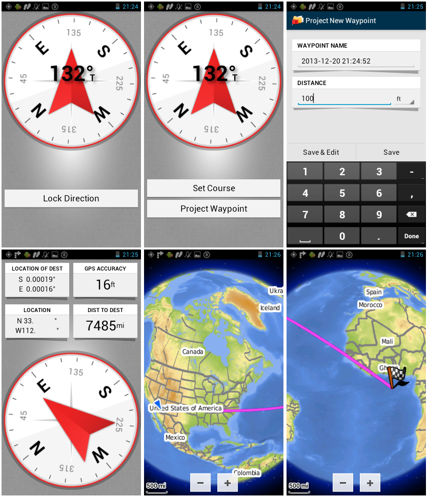
Sight 'N Go application always projects waypoints using coordinates S
0.00000° E 0.00000° as the GPSr current position. [example 01] [wiki] [21DEC13] [2.20_1.16.00] [2.20_1.17.00] [Resolved 2.20_1.18.00]
-
The 'Distance to Geocache' value displayed beside the compass after selecting [Geocaching > {any geocache} > Map] always shows the original value and is not dynamically updated. [groundspeak] [19JAN14] [2.20_1.16.00] [2.20_1.18.00] [2.20_1.19.00]
[2.90_1.20.00] [Resolved 3.20_1.21.00]
-
The currently selected geocache is not displayed on the map after selecting [Geocaching > {any geocache} > Map]. [19JAN14] [2.20_1.16.00] [2.20_1.17.00] [Resolved 2.20_1.18.00]
-
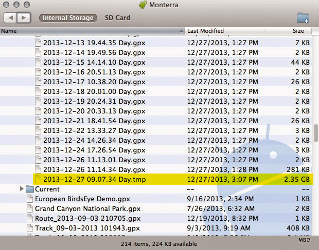
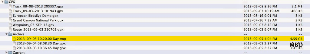
Monterra intermittently creates excessively large and erroneous temporary files in GPX directory, consuming available memory resources resulting in poor overall device performance. [wiki] [example 01 02] [29JAN14] [2.20_1.15.00] [2.20_1.16.00] [2.20_1.17.00] [2.20_1.18.00] [2.20_1.19.00] [2.90_1.20.00]
-
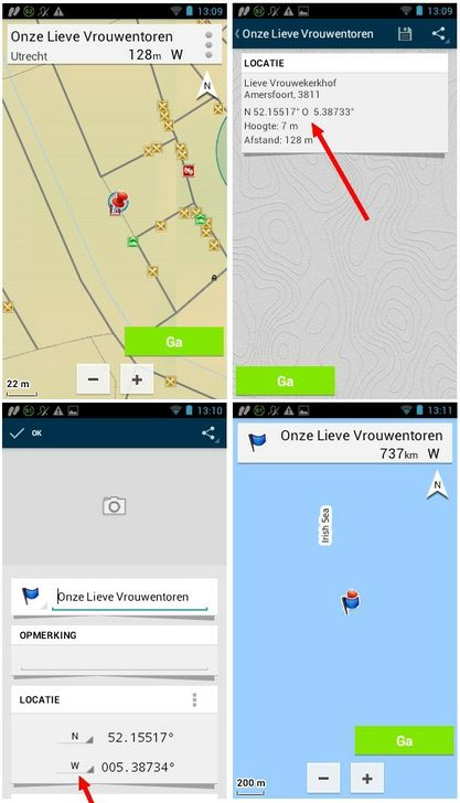
Eastern Longitude is saved as Western Longitude when saving waypoints. [example 01] [wiki] [08MAR14] [2.20_1.18.00] [Resolved 2.20_1.19.00]
-
Geocache Size is not always properly displayed in Geocache Dashboard for languages other than English. [example] [02APR14] [2.20_1.19.00] [Resolved 3.20_1.21.00]
-
Selecting [No] when prompted "Find the next closest geocache?" after logging a geocache returns the user to the Geocache Information page for the just logged geocache. [02APR14] [2.20_1.19.00]
-
Trip Odometer Data Field is inoperative. [wiki] [26APR14] [2.20_1.18.00] [2.20_1.19.00] [2.90_1.20.00]
-
Track Distance Data Field is Inoperative. [wiki] [26APR14] [2.20_1.18.00] [2.20_1.19.00] [2.90_1.20.00]
-
Moving AVG Data Field is inoperative. [wiki] [26APR14] [2.20_1.18.00] [2.20_1.19.00] [2.90_1.20.00]
-
Overall AVG Data Field is inoperative. [wiki] [26APR14] [2.20_1.18.00] [2.20_1.19.00] [2.90_1.20.00]
-
Track Log recording does not 'Auto Archive' when set to 'Daily'. [wiki] [29APR14] [2.20_1.19.00] [Resolved 3.20_1.21.00]
-
GOA only allows 50 waypoints when calculating direct routes. [wiki] [20JUN14] [2.90_1.20.00] [3.20_1.21.00]
[3.50_1.23.00] [Resolved 4.10_1.28.00]
-
Monterra is unable to program a brand new Chirp. [groundspeak] [16AUG14] [3.50_1.23.00]
Crash Reports
- GOA crashes immediately when any language other than English is selected. [groundspeak] [03DEC13] [2.20_1.15.00] [2.20_1.16.00] [Resolved 2.20_1.17.00]
-
GOA crashes frequently during normal operation with English language selected. [05DEC13] [2.20_1.15.00]
-
Enabling the Large Data Fields dashboard while in landscape mode crashes GOA. [05DEC13] [2.20_1.15.00] [Resolved 2.20_1.16.00]
Hardware Failures
Missing Features
- Monterra does not currently support/recognize 'CustomSymbols' directory. [05DEC13]
-
Monterra does not currently include a 'Share Wirelessly' application. [05DEC13]
-
The first screen touch after the back light has timed out should activate only the back light. [20DEC13]
-
Compass calibration sequence does not offer a 'validation pause' between each step. [20DEC13]
-
Monterra does not currently support/recognize custom POI icons/symbols. [19JAN14]
-
Monterra does not currently support VIRB Remote via ANT+. [wiki] [29MAR14]
-
Monterra does not currently have a [Man Overboard] function similar to all previous Garmin GPSr that support marine maps. [wiki] [29JUN14] [Added 3.50_1.23.00]
Requested Features
- Please include option to share audio via Bluetooth. [29NOV13]
-
Please add support for multi-channel selective pairing via Bluetooth. [adv] [29JAN14]
-
Please add support for Garmin TPMS. [wiki] [22MAR14]
END

