| |
 |
 |
 |
| Gen I |
Montana 700
010-02133-00 |
Montana 700i
010-02347-10 |
Montana 750i
010-02347-00 |
| Gen II |
Montana 710
010-02963-00 |
Montana 710i
010-02964-00 |
Montana 760i
010-02964-10 |
| General |
| Unit Dimensions |
3.4” x
7.2” x 1.3” (8.76 x 18.30 x 3.27 cm) |
3.6” x
7.2” x 1.3” (9.19 x 18.30 x 3.27 cm) |
| Weight |
14.0
oz (397 g) with Li-ion battery pack |
14.5
oz (410 g) with Li-ion battery pack |
| Display Size |
2.55" x 4.25" (6.48 x 10.80 cm) |
| Display Resolution |
480 x 800 pixels (188 ppi) |
| Display Type |
5.0"
(12.70 cm) transflective
WVGA |
| Touchscreen |
Yes |
| Waterproofing |
IPX7 |
| Rugged Design |
MIL STD 810G |
| Floats |
No |
| Battery |
AA Battery Pack or
Lithium-ion Battery Pack |
Lithium-ion Battery Pack |
|
Battery Life |
18+ hours (GPS mode)
330+ hours (Expedition Mode) |
18+ hours (GPS mode, 10 min Tracking)
300+ hours (Expedition Mode, 30 min Tracking) |
| Integral Battery
Charger |
Yes |
| GNSS Antenna |
Quad Helix |
| GNSS Chipset |
Type M5
(3313) |
| GNSS Receiver |
High
Sensitivity |
|
Multi-GNSS |
Yes |
|
Multi-Band |
No |
|
GNSS Networks |
GPS +
[GLONASS
or
Galileo] +
WAAS/EGNOS |
GPS +
Galileo +
WAAS/EGNOS |
|
Iridium Modem |
No |
SBD |
| Interface |
micro USB (700 / 700i / 750i)
USB-C (710 / 710i / 760i) |
| Operating Temperature |
-4° to 140°F (-20° to 60°C) |
| Charging Temperature |
-4° to
32°F (-20° to 0°C) Slow speed charging to full capacity (710 / 710i
/ 760i)
32° to
113°F (0° to 45°C) Full speed charging to full capacity
113° to
140°F (45° to 60°C) Full speed charging to ~85% capacity (710 / 710i
/ 760i) |
| Maps and Memory |
| Basemap |
Yes |
| City
Navigator |
No |
Yes |
| Public Lands |
700 |
700i / 750i |
| TopoActive (Regional) |
700 |
700i / 750i |
| TopoActive (WorldWide) |
710 |
710i / 760i |
|
Outdoor Maps+ |
Yes |
| Ability to Add Maps |
Yes (15,000
map segments) |
| Garmin Custom Maps |
Yes (500
custom map tiles) |
| Garmin BirdsEye Maps |
Yes (250
BirdsEye maps) |
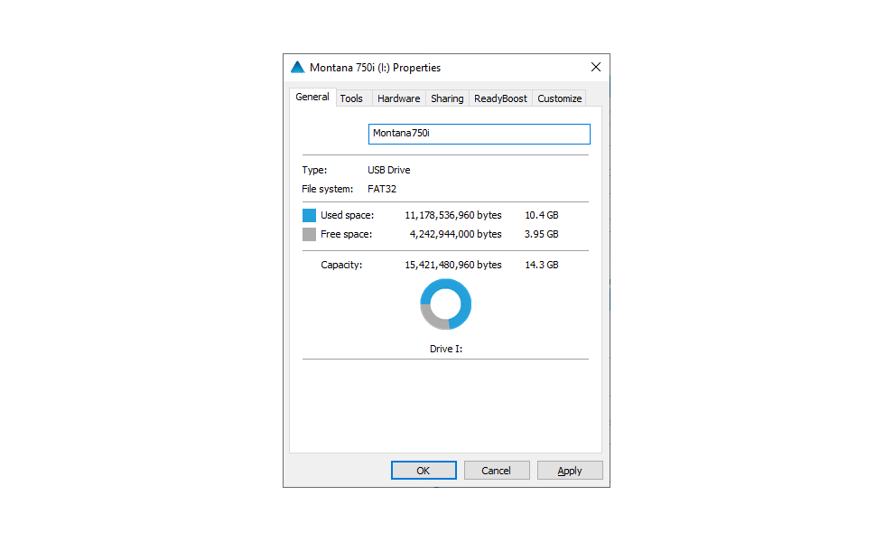
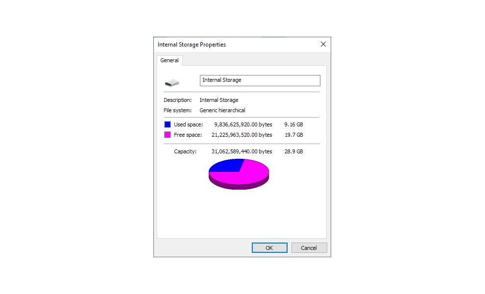
| Internal Memory |
14.3 GB (700 / 700i / 750i)
28.9 GB (710 / 710i / 760i) |
| Accepts Data Card |
Yes (microSD,
Max 32GB, Class 4 to 10) |
| Custom POI |
Yes |
| Waypoints |
10,000 |
| Routes |
250 |
| Courses |
250 |
| Activities |
20,000 points
(300 saved fit activities) |
| Track Log |
20,000 points
(250 saved gpx tracks, 2,000 archived tracks) |
| Automatic Routing |
Yes (with routable maps) |
| Sensors |
| Electric Compass |
Yes
(3-axis) |
| Barometric Altimeter |
Yes |
| UV Sensor |
No |
| Microphone |
| External Antenna |
SMB |
| Outdoor Recreational Features |
| Geocaching Friendly |
Yes (Paperless) - Load millions of geocaches manually (GPX +
GGZ) and wirelessly (via GCLive) |
| Outdoor GPS Games |
No |
| LED Beacon Flashlight |
Yes |
| Camera |
No |
Yes |
| Photo Viewer |
Yes |
| Photo Navigation |
| Hunt/Fish Calendar |
| Sun/Moon Information |
| Area Calculation |
| Tide Tables |
Yes (with optional Bluechart) |
| Radio |
No |
| Multimedia |
| inReach |
| inReach SOS Rescue |
No |
Yes |
| inReach Tracking |
| inReach Weather |
| inReach Messaging |
| inReach Remote |
Yes |
No |
| Wireless |
| Garmin Connect |
Yes |
| Garmin Explore |
| Smart Notifications |
| LiveTrack |
| Unit to Unit Data Transfer |
| Connect IQ Applications |
| Active Weather |
| VIRB Remote |
| DogTrack |
| XERO Locations |
| RINEX Logging |