Outdoor Maps+

 
  • With Outdoor Maps+, you have access to a wide variety of premium mapping across the globe.
  • Content is regularly updated and delivered directly to your compatible Garmin device via Wi-Fi connectivity.
  • Read the Garmin Outdoor Maps+ press release.
    Multiple map layers let you view elevation contours, land boundaries, wildlife areas and more.
    Easy downloads via Wi-Fi deliver fresh map data directly to your Garmin device.
    Content is regularly updated and expanded to keep you tracking with the latest information.
    Access premium maps on all your compatible Garmin products with a single subscription.


Map Layers


Atlas Points Hunting Stand Locations Ride Trail Map
Boat Ramps Huts Satellite Imagery 
Boundaries Hydro SkiView
British Mountain  IGN France  SnowView
Buildings  Japan Raster  Superwalker (HARVEY)
Burn Zones LTE Voice Coverage  Survey Marks
Campgrounds Mini Golf   SwissTopo
Chronic Wasting Disease (CWD) Night Lights   Topo
FS Topo NRC CanTopo  Topo Pro
Garmin Trails NZTopo50  Trailmaps
Great Britain Raster Outdoor Points of Interest (POI) Tree Species
HD Contours Parcels USFS Points
HD Relief Shading Public Lands USGS Quads
Heritage Points Public Land Survey System (PLSS) Walk-In Hunting Areas (WIHA)
Hunt and Fish Raster  


Atlas Points
 
  • DeLorme Atlas & Gazetteer topographical map series points.

  • Locate U.S. points of interest, such as unique natural features like mountains and waterfalls, available outdoor recreational activities, family-friendly attractions, recreational areas such as state/national parks/forests and places to fish or hunt.

  • Coverage is available for all 50 U.S. States.

  • Map Layers Index


Boat Ramps
 
  • Provides locations of boat ramps and kayak and canoe launch sites with the ability to search for trailerable or non-trailerable ramps.

  • Trailerable ramps are indicated with a solid icon on the map and non-trailerable ramps are indicated with an outlined icon.

      Trailerable
      Non-trailerable

  • Coverage is available for all 50 U.S. States.

  • Map Layers Index


Boundaries
 
  • See European countries, international borders, states, provinces, counties and more. Easily disable the borders when you do not need them.

  • Coverage is available for Albania, Andorra, Armenia, Austria, Azerbaijan, Belgium, Bosnia and Herzegovina, Bulgaria, Croatia, Cyprus, Czechia, Denmark, Estonia, Faroe Islands, Finland, France, Georgia, Germany, Greece, Hungary, Iceland, Ireland, Italy, Kosovo, Latvia, Liechtenstein, Lithuania, Luxembourg, Malta, Moldova, Monaco, Montenegro, the Netherlands, North Macedonia, Norway, Poland, Portugal, Romania, San Marino, Serbia, Slovakia, Slovenia, Spain, Sweden, Switzerland, Türkiye, Ukraine, United Kingdom, and Vatican City.

  • Map Layers Index


British Mountain
 
  • Detailed 1:40,000 scale maps of national parks and other beautiful walking areas in the UK.

  • Developed in conjunction with the British Mountaineering Council (BMC), these maps of some of the most popular outdoor areas are detailed and feature layer colouring for easy identification of hills and valleys, named climbing crags, and public rights of way (England and Wales).

  • HARVEY Maps was set up in 1977 to produce maps that would give people the freedom to enjoy walking, cycling, and running in open spaces.

  • The mapping is created using original photogrammetric and field surveys which makes it reliable, detailed, and easy to read. All of the maps are made by walkers, for walkers. 

  • Provided by HARVEY Maps.

  • Raster Maps

  • Map Layers Index


Buildings
 
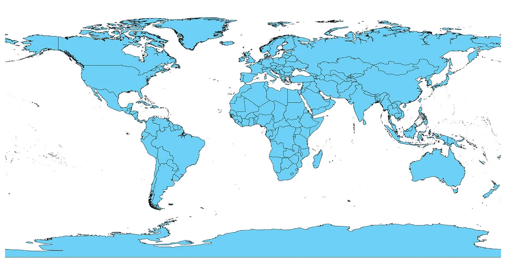
  • Gain your bearings or get help planning a route with a map layer that displays 2D building footprints for multiple countries.

  • Coverage is available for Albania, Andorra, Anguilla, Antigua and Barbuda, Armenia, Australia, Austria, Azerbaijan, the Bahamas, Barbados, Belgium, Belize, Bosnia and Herzegovina, British Virgin Islands, Bulgaria, Canada, Cayman Islands, Costa Rica, Croatia, Cyprus, Czechia, Denmark, Dominica, Dominican Republic, Dutch Caribbean, El Salvador, Estonia, Faroe Islands, Finland, France, Georgia, Germany, Greece, Grenada, Guadalupe, Guatemala, Haiti, Honduras, Hungary, Iceland, Ireland, Israel, Italy, Jamaica, Kosovo, Latvia, Liechtenstein, Lithuania, Luxembourg, Malta, Martinique, Mexico, Moldova, Monaco, Montenegro, the Netherlands, New Zealand, Nicaragua, North Macedonia, Norway, Panama, Poland, Portugal, Puerto Rico, Romania, San Marino, Saint Barthélemy, Saint Kitts and Nevis, Saint Lucia, Saint, Martin, Saint Vincent and the Grenadines, Serbia, Slovakia, Slovenia, South Africa, Spain, Sweden, Switzerland, Trinidad and Tobago, Türkiye, Turks and Caicos Islands, Ukraine, United Kingdom, U.S., U.S. Virgin Islands, and Vatican City. 

  • Map Layers Index


Burn Zones
 
  • See where wildfires or controlled burns have happened, with important details such as when the burn took place.

  • Useful for predicting the potential for unstable hiking terrain, scouting hunting locations, and mushroom foraging

  • Can be configured to display burn areas based on age of burn:

    • Burn Year: 1
    • Burn Year: 2-5
    • Burn Year: 6-10
    • Burn Year: 11-15
    • Burn Year: 15+

  • Coverage is available for all 50 U.S. States. 

  • Map Layers Index


Campgrounds
 
  • Find a spot to spend the night, and check which amenities - such as water, toilets or electricity - are provided before you arrive.

  • Supplemented with photos where available.

  • Coverage is available for all 50 U.S. States and Canada.

  • Map Layers Index


Chronic Wasting Disease (CWD)
 
  • See where chronic wasting disease-restricted areas exist, and know the regulations for that specific area.

  • Know before you go - harvesting deer in CWD-positive areas may come with hunting, transportation and additional restrictions. 

  • Coverage is available in parts of Canada (Alberta, British Columbia, Manitoba, Saskatchewan) and the United States (all states except for Alaska, Arizona, Connecticut, Delaware, Georgia, Maine, Massachusetts, New Hampshire, New Jersey, Oregon, Rhode Island, South Carolina, and Vermont).

  • Map Layers Index


FS Topo
 
  • Raster United States Forest Service Topographic Maps for all National Forests in the United States and territory of Puerto Rico.

  • Scale is 1:24,000, except in Alaska where it is 1:25,000.

  • USDA Forest Service, Geospatial Technology and Applications Center (GTAC).

  • Coverage is available for all 50 U.S. States and Puerto Rico.

  • Raster Maps

  • Map Layers Index


Garmin Trails
 
  • Garmin Trails provides access to thousands of trails in the Garmin Connect app or the Garmin Explore app.

  • Filter and find the trail with the features you are wanting.

  • Review the details that include difficulty, distance, total ascent & descent along with reviews and photos from others in the community.

  • With an active Garmin Connect+ or Outdoor Maps+ subscription, the trails can be sent directly to your compatible device.

  • Coverage is available for all 50 U.S. States, Austria, Canada, France, Germany, Liechtenstein, Luxembourg, Monaco, Slovenia, Switzerland, and Taiwan.

  • Map Layers Index


Great Britain Raster
 
  • Raster maps of Great Britain at a 1:10,000 scale (10K).

  • Data is provided by Ordnance Survey as part of their free OpenData.

  • Public sector information is licensed under the Open Government License v3.0.

  • Coverage is available for Great Britain.

  • Raster Maps

  • Map Layers Index


HD Contours
 
  • Provides elevation mapping with premium contours, comparable to 1:24,000 scale (24K) USGS maps.

  • Topo map content includes multiple layers of map information by state that can be enabled or disabled individually once downloaded. This provides more detail when compared to the TopoActive map that comes pre-loaded on compatible Garmin devices.

  • Coverage is available for all 50 U.S. States.

  • Map Layers Index


HD Relief Shading
 
  • Improved mapping detail with shading that helps visually depict elevation changes and terrain features.

  • Downloading HD shading will also add Slope Angle and Slope Aspect layers for compatible devices.

  • Coverage is available for all 50 U.S. States, Andorra, Austria, Belgium, Canada, Czechia, Denmark, Estonia, Finland, France, Germany, Iceland, Ireland, Italy, Latvia, Liechtenstein, Luxembourg, Malta, Monaco, the Netherlands, Norway, Poland, Portugal, San Marino, Slovakia, Slovenia, Spain, Sweden, Switzerland, United Kingdom, and Vatican City. 

  • Map Layers Index


Heritage Points
 
  • See castles, forts, lighthouses, religious sites, and other historic points of interest around the world overlaid on the map.

  • Coverage Map

  • Map Layers Index


Hunt and Fish (formerly HMU Hunting Management Units)
 
  • Map overlay of hunt management and fish management zones.

  • Hunt includes game or wildlife management unit boundaries specified by the state or province for the purpose of regulating hunting activities.

  • Fish includes Fish Management Zones used for planning of stocking and monitoring fish populations.

  • Species and information vary by state or province based on regulations.

  • Coverage is available for all 50 U.S. States, Canada, and New Zealand. 

  • Updated annually.

  • U.S. HuntView Parcel Coverage Map

  • Map Layers Index


Hunting Stand Locations
 
  • This feature shows the location of more than 200,000 hunting stands, lookout points, platforms and viewpoints throughout popular European hunting areas. 

  • Coverage includes Armenia, Austria, Azerbaijan, Belgium, Bosnia and Herzegovina, Bulgaria, Croatia, Cyprus, Czechia, Denmark, Estonia, Finland, France, Georgia, Germany, Greece, Hungary, Iceland, Ireland, Italy, Kosovo, Latvia, Liechtenstein, Lithuania, Luxembourg, Malta, Moldova, Montenegro, the Netherlands, North Macedonia, Norway, Poland, Portugal, Romania, San Marino, Serbia, Slovakia, Slovenia, Spain, Sweden, Switzerland, Türkiye, Ukraine, the United Kingdom and Vatican City.

  • Map Layers Index


Huts
 
  • This database includes huts, mountain hostels, refuges, or similar facilities, as well as business information.

  • Rich content depends on local provider. 

  • Coverage includes Europe, Middle East, Africa, Australia, and New Zealand.

  • Updated annually.

  • Map Layers Index


Hydro
 
  • Detailed mapping of surface water features from the National Hydrography Dataset (NHD), including inland lakes, rivers, streams, and wetland features.

  • NOTE: This does not include depth range shading, shallow water shading, or lake contours. 

  • Topo map content includes multiple layers of map information by state that can be enabled or disabled individually once downloaded. This provides more detail when compared to the TopoActive map that comes pre-loaded on compatible Garmin devices.

  • Coverage is available for all 50 U.S. States.

  • Map Layers Index


IGN France
 
  • National raster maps for France produced by the Institut Géographique National (IGN).

  • Coverage is available for France.

  • Raster Maps

  • Map Layers Index


Japan Rasters
 
  • Digital 1:25,000 scale topographic map of Japan.

  • From the Geospatial Information Authority of Japan.

  • Coverage is available for Japan.

  • Raster Maps

  • Map Layers Index


LTE Voice Coverage
 
  • Know if you’ll have cell service before you go.

  • This map layer shows voice coverage for AT&T, Verizon, US Cellular and T-Mobile wireless carriers.

  • Easily filter the results based on your cell carrier.

  • LTE Voice Coverage displayed on Outdoor Maps+ comes from the FCC Broadband Data Collection National Broadband Map, which includes coverage availability reported by Internet Service Providers (ISPs). The FCC updates this data twice per year, approximately 6 months after it is received from the ISPs, and we update our map within about 2 months.

  • This data is not available for every LTE service provider or every geographic region.

  • Coverage is available for all 50 U.S. States, Puerto Rico and the U.S. Virgin Islands.

  • Map Layers Index


Mini Golf
 
  • Database of miniature golf locations.

  • Includes business information where available.

  • Coverage is available for all 50 U.S. States.

  • Updated annually.

  • Map Layers Index


Night Lights
 
  • Map depicting the amount of artificial light pollution affecting the night sky.

  • Generally used for camping and star gazing.

  • Where there is a darker gradient of gray it indicates a higher concentration of lights in that area.

  • Coverage is available between 80ºN latitude and 60ºS latitude. 

  • Map Layers Index


NRC CanTopo
 
  • High quality national topo raster maps produced by Natural Resources Canada (NRC) that display terrain contours, trails, points of interest, water sources, and more.

  • Coverage is available for Canada. 

  • Raster Maps

  • Map Layers Index


NZTopo50
 
  • Raster Maps of New Zealand at a scale of 1:50,000.

  • Maps provided by Land Information New Zealand (LINZ).

  • Coverage is available for New Zealand.

  • Raster Maps

  • Map Layers Index


Outdoor Points of Interest (POI)
 
  • Whether you’re cycling, paddling, camping, hiking, fishing or anything in between, it’s easy to find a new place to explore.

  • Discover points of interest - such as boat ramps and campgrounds, national parks and historic sites, picnic areas and zoos. 

  • Information is sourced from DeLorme Atlas & Gazetteer points, U.S. Forest Service points and more.

  • Topo map content includes multiple layers of map information by state that can be enabled or disabled individually once downloaded. This provides more detail when compared to the TopoActive map that comes pre-loaded on compatible Garmin devices.

  • Coverage is available for all 50 U.S. States.

  • Map Layers Index


Parcels
 
  • Also known as state plat maps, these maps help to identify landowner names and boundaries for public/private land types.

  • Coverage is available for all 50 U.S. States (see Parcel Coverage PDF), Austria, Belgium, Croatia, Czechia, Denmark, Estonia, Finland, France, Great Britain, Iceland, Ireland, Israel, Japan, Latvia, Luxembourg, New Zealand, the Netherlands, Norway, Slovakia, Slovenia, South Africa, Spain and Sweden. 

  • Map Layers Index


Public Lands
 
  • Respect private landowners and venture into public lands.

  • This color-coded map overlay makes it easy to identify state and national public land boundaries, national and state parks, national forests, reservations, Bureau of Land Management, WMAs, and more.

  • Public Land Management Key:
  Bereau of Indian Affairs   National Monument
  Bureau of Land Management (BLM)   National Parkway
  BLM Wilderness Area   National Scenic River
  Bureau of Reclamation   NPS Wilderness Area
  Department of Defense   USFS Wilderness Area
  Army Corps of Engineers   Fish & Wildlife Service (FWS)
  National Forest   Wildlife Management Area
  National Grasslands   USFWS Wilderness Area
  Major National Park   Tennesse Valley Authority
  National Recreational Area   Private or Unknown


Public Land Survey System (PLSS)
 
  • Displays Bureau of Land Management townships, range and section information, and USGS quad locations.

  • Topo map content includes multiple layers of map information by state that can be enabled or disabled individually once downloaded. This provides more detail when compared to the TopoActive map that comes pre-loaded on compatible Garmin devices.

  • Coverage is available for all 50 U.S. States.

  • Map Layers Index


Raster
 
  • Get highly detailed raster maps that display trailheads and trails, camping areas, points of interest, water sources and more.

  • Data from leading providers is as follows:


  • Map Layers Index


Ride Trail Map
 
  • Find your next ride with a detailed mountain bike trail network overlay for the Alps region and other popular MTB areas in Europe.

  • Fom Swiss Sports Publishing GmbH.

  • Coverage is available for Austria, France, Germany, Italy, Portugal, Slovenia, Spain, and Switzerland. 

  • Map Layers Index


Satellite Imagery
 
  • Worldwide coverage that provides a photorealistic perspective from above.

  • Imagery resolution may vary.

  • NOTE: Satellite imagery is already available to download for free on compatible Garmin handheld devices without an Outdoor Maps+ subscription. 

  • Coverage Map

  • Map Layers Index


SkiView
 
  • View ski lifts and downhill ski run names with difficulty information for thousands of ski resorts worldwide plus hundreds of miles of cross-country and skate skiing trails.

  • Overlay this information on the map with elevation and terrain features.

  • Allows for improved situational awareness when viewing the map data page while skiing or snowboarding.

  • These maps are optimized to show run names with difficulty ratings, viewable at a glance for each run.

  • Coverage Info

  • Map Layers Index


SnowView
 
  • View winter satellite imagery for more than 1,000 ski areas worldwide to help you plan your adventures on the slopes.

  • Coverage Info

  • Map Layers Index


Superwalker (HARVEY)
 
  • Detailed 1:25,000 scale maps of the UK and 1:30,000 scale maps of Ireland, these maps reproduce the popular Superwalker and British Mountain Harvey Maps available for some of the most popular outdoor regions.

  • HARVEY Superwalker maps are developed with clarity and ease of use in mind and are perfect for walkers and hikers looking for detailed mapping without the clutter.

  • Only relevant information is shown and the land is depicted using hand drawn and accurate contours.

  • Public rights of way are shown (England and Wales).

  • Provided by HARVEY Maps.

  • Raster Maps

  • Map Layers Index


Survey Marks
 
  • This feature includes more than 803k benchmarks in the U.S. and more than 31k trig points in Great Britain.

  • Expanded to cover Australia, Canada, New Zealand, Northern Ireland, Republic of Ireland and South Africa.

  • These survey marks indicate the precise vertical or horizontal position of various locations.

  • Outdoor enthusiasts who enjoy hobbies such as benchmark hunting or trig bagging can search for these survey marks to use as a destination and grab a photo as evidence that they’ve been there.

  • Coverage Map

  • Map Layers Index


SwissTopo
 
  • High quality national topo raster maps produced by swisstopo that display terrain contours, trails, points of interest, water sources, and more.

  • Coverage is available for Switzerland.

  • Raster Maps

  • Map Layers Index


TOPO
 
  • Topo map content includes multiple layers of map information by state that can be enabled or disabled individually once downloaded.

  • This provides more detail when compared to the TopoActive map that comes pre-loaded on compatible Garmin devices.

    • HD Contours - Provides elevation mapping with premium contours, comparable to 1:24,000 scale (24K) USGS maps.

    • Hydro - Detailed mapping of surface water features from the National Hydrography Dataset (NHD), including inland lakes, rivers, streams, and wetland features.

    • Outdoor POI - Points of interest for natural features and outdoor destinations.

    • PLSS (Public Land Survey System) - Displays Bureau of Land Management townships, range and section information, and USGS quad locations.

  • Coverage is available for all 50 U.S. States. 

  • Map Layers Index


TOPO Pro
 
  • Provides mapping content from premium local providers for multiple countries in Europe, with roads and trails, points of interest, contour lines, and more.

  • Coverage is available for Albania, Andorra, Austria, Bosnia and Herzegovina, Croatia, Czechia, Finland, France, Germany, Italy, Kosovo, Liechtenstein, Monaco, Montenegro, North Macedonia, Norway, San Marino, Serbia, Slovenia, Spain, Sweden, Switzerland, and Vatican City.

  • Map Layers Index


Trailmaps
 
  • Use this map overlay to locate trails of interest and distinguish which trail you’re on while hiking.

  • Reference the waymarked/blazed international, national and local trail network, identified with physical waymark color and well-known trail names across many European countries.

  • Coverage Map 

  • Map Layers Index


Tree Species
 
  • This map overlay depicts tree species based on a combination of tree type and canopy:

    Closed Canopy Broadleaf 
    Closed Canopy Needleleaf 
    Closed Canopy Mixed 
    Medium Canopy Broadleaf 
    Medium Canopy Needleleaf 
    Medium Canopy Mixes 
    Open Canopy Braodleaf 
    Open Canopy Needleleaf 
    Open Canopy Mixed 


  • Map Layers Index


USFS Points
 
  • Comprehensive directory of United States Forest Service locations for camping, hiking, picnicking, outdoor learning, nature viewing, fishing, and more.

  • Coverage is available for all 50 U.S. States. 

  • Map Layers Index


USGS Quads
 
  • High-quality 1:24,000 scale U.S. Geological Survey raster maps that display terrain contours, trailheads, camping areas, trails, points of interest, water sources, and more.

  • Coverage is available for all 50 U.S. States. 

  • Raster Maps

  • Map Layers Index


Walk-In Hunting Areas (WIHA)
 
  • Expand your hunting opportunities with this map layer.

  • See active walk-in hunting property boundaries where private landowners permit access to their properties for hunting through voluntary public access programs.

  • Always defer to the most up-to-date information from local regulatory agencies and posted signage, and remain aware of property boundaries.

  • Coverage is available in parts of the United States (Colorado, Idaho, Kansas, Minnesota, Montana, Nebraska, North Dakota, Oregon, and South Dakota).

  • Map Layers Index