|
|
|
|
|
|
|
|
|
Overview |
|
|
|
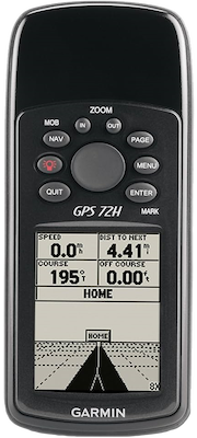
Make a splash with the GPS 72H, a lightweight, water resistant
handheld that floats. Simple yet robust, the GPS 72H features
high-sensitivity GPS and a USB connection along with its large
screen, simple operation and rock-solid performance. |
|
|
|
Acquire Satellites Quickly |
|
Find your way effortlessly with the GPS 72H's high-sensitivity
GPS receiver. GPS 72H acquires satellite signals quickly and
tracks your location in challenging conditions, such as heavy
tree cover or deep canyons. |
|
|
|
Use on Land or Water |
|
Don't worry about losing this GPS device in the drink. The GPS
72H floats in water, and it's water resistant (IPX7) to
withstand the accidental dunk or splash in the lake. Whether on
water or land, the GPS 72H can save up to 500 of your favorite
places in memory and point you to your destination (no street or
terrain maps). |
|
|
|
Store Important Data |
|
The GPS 72H is NMEA 0183 compatible. To transfer data to your
device, GPS 72H easily connects to your computer via USB. If
you're into boating, hunting or fishing, you can use the 72H's
built-in celestial data, which includes sunrise/sunset times and
a hunting and fishing calendar. |
|
|
|
|
|
Specifications |
|
|
|
Part Numbers |
010-00840-01, 010-00840-02 (International) |
|
Unit Dimensions |
2.7" x 6.2" x 1.2" (6.9 cm x 15.7 cm x 3.0 cm) |
|
Display Size |
1.6" x 2.2" (4.1 cm x 5.6 cm), 2.7" Diag (6.8 cm) |
|
Display Resolution |
120 x 160 |
|
Display Type |
High contrast FSTN, 4-level gray scale monochrome LCD |
|
Weight |
6.1 oz (173 g) without batteries |
|
Battery Type |
AA x 2 |
|
Battery Life |
18 hours (Battery Save Mode Enabled) |
|
Operating Temperature |
5° F to 140° F (-15° C to 60° C) |
|
Waterproof |
IPX7 |
|
Floats |
Yes |
|
Interface |
NMEA 0183 USB + Serial |
|
GPS Receiver |
High Sensitivity,
WAAS enabled, 12 parallel channels |
|
GPS Antenna |
Patch |
|
External GPS Antenna |
No |
|
GPS Constellations |
GPS +
WAAS |
|
GPS Position
Accuracy (95%) |
< 15 meters (GPS), 3 meters (WAAS) |
|
GPS Velocity Accuracy |
0.05 meter / second steady state |
|
GPS Hot Start |
< 3 seconds |
|
GPS Warm Start |
< 15 seconds |
|
GPS Cold Start |
< 45 seconds |
|
GPS Update Rate |
1 / second, continuous |
|
Altimeter |
GPS |
|
Barometer |
No |
|
Compass |
GPS |
|
Routes |
50 |
|
Tracks |
10 |
|
Waypoints |
500 |
|
Outdoor GPS Games |
No |
|
Almanac Information |
Yes (Tides, Sun and Moon, Hunt and Fish) |
|
Area Calculation |
Yes |
|
Point-to-Point Navigation |
Yes |
|
On Road Navigation |
No |
|
MOB |
Yes |
|
TracBack |
Yes |
|
Trip Info |
Yes |
|
Track Log |
Yes (2,048 points per track) |
|
Internal Memory |
1 MB |
|
Expandable Memory |
No |
|
Pre Loaded POIs |
Yes (marine
point database) |
|
Can Add POIs |
Yes |
|
Pre Loaded Maps |
No |
|
Can
Add Maps |
No |
|
|
|
|
|
Documents |
|
|
|
GPS 72H Owners Manual |
|
GPS 72H Quick Start Guide |
|
Sailing Terminology |
|
An Introduction to using Garmin GPSr with paper maps |
|
|
|
|
|
Media |
|
|
|
10SEP09 - Garmin Updates Low-Cost, High-Sensitivity GPS 72H
Marine Handheld |
|
|
|
|
|
Update History |
|
|
|
Tip: When MapSource data is
loaded to this GPS unit, the preloaded Marine POI database is
erased. Please use this
Marine POI database file to restore original factory
installed map data. If MapSource data is currently loaded on the
GPS unit, it will be erased and replaced with this Marine POI
database. |
|
|
|
006-B1095-00 |
|
|
|
3.10 |
- Fix incorrect time date issue.
|
|
|
|
2.80 |
- Update magnetic variation table.
- Fixed German translation of string 'sunset' and
'moonrise'.
|
|
|
|
2.70 |
- Update magnetic variation table.
- Fixed SBAS tracking shutdown.
|
|
|
|
2.40 |
- Fix abnormal NMEA output rate.
|
|
|
|
2.30 |
- Support Clear User Data hot key (MENU+POWER key).
- Support NMEA input $GPWPL and $PGRMW sentences.
|
|
|
|
|