|
|
|
|
|
|
|
|
|
Overview |
|
|
|
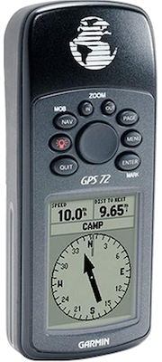
The mariner-friendly GPS 72 is WAAS-enabled for accuracy to
within 9.84 ft (3 m) and features a large screen and easy-to-use
buttons. |
|
|
|
Use on Land or Water |
|
Don't worry about losing this GPS device in the drink. The GPS
72 floats in water, and its IPX7 water resistant to withstand
the accidental dunk or splash in the lake. Whether on water or
land, the GPS 72 can save up to 500 of your favorite places in
memory and point you to your destination (no street or terrain
maps). If you're into boating, hunting or fishing, you can use
the 72's built-in celestial data, which includes tide
information, sunrise/sunset times and a hunting and fishing
calendar. |
|
|
|
|
|
Specifications |
|
|
|
Part Numbers |
010-00309-00 (Americas), 010-00309-01 (Intl), 010-00309-03
(bilingual), 010-00309-11 (Intl, RoHS) |
|
Unit Dimensions |
2.7" x 6.2" x 1.2" (6.9 cm x 15.7 cm x 3.0 cm) |
|
Display Size |
1.6" x 2.2" (4.1 cm x 5.6 cm), 2.7" Diag (6.8 cm) |
|
Display Resolution |
120 x 160 |
|
Display Type |
High contrast FSTN, 4-level gray scale monochrome LCD |
|
Weight |
6.1 oz (173 g) without batteries |
|
Battery Type |
AA x 2 |
|
Battery Life |
16 hours (Battery Save Mode Enabled) |
|
Operating Temperature |
5° F to 158° F (-15° C to 70° C) |
|
Waterproof |
IPX7 |
|
Floats |
Yes |
|
Interface |
NMEA 0183 USB + Serial |
|
GPS Receiver |
WAAS enabled, 12 parallel channels |
|
GPS Antenna |
Patch |
|
External GPS Antenna |
No |
|
GPS Constellations |
GPS +
WAAS |
|
GPS Position
Accuracy (95%) |
< 15 meters (GPS), 3 meters (WAAS) |
|
GPS Velocity Accuracy |
0.05 meter / second steady state |
|
GPS Hot Start |
< 3 seconds |
|
GPS Warm Start |
< 15 seconds |
|
GPS Cold Start |
< 45 seconds |
|
GPS Update Rate |
1 / second, continuous |
|
Altimeter |
GPS |
|
Barometer |
No |
|
Compass |
GPS |
|
Routes |
50 |
|
Tracks |
10 |
|
Waypoints |
500 |
|
Outdoor GPS Games |
No |
|
Almanac Information |
Yes (Tides, Sun and Moon, Hunt and Fish) |
|
Area Calculation |
Yes |
|
Point-to-Point Navigation |
Yes |
|
On Road Navigation |
No |
|
MOB |
No |
|
TracBack |
Yes |
|
Trip Info |
Yes |
|
Track Log |
Yes (2,048 points per track) |
|
Internal Memory |
1 MB |
|
Expandable Memory |
No |
|
Pre Loaded POIs |
Yes (marine
point database) |
|
Can Add POIs |
Yes |
|
Pre Loaded Maps |
No |
|
Can
Add Maps |
No |
|
|
|
|
|
Documents |
|
|
|
GPS 72 Owners Manual |
|
GPS 72 Quick Start Guide |
|
Sailing Terminology |
|
An Introduction to using Garmin GPSr with paper maps |
|
|
|
|
|
Media |
|
|
|
08AUG02 - Garmin’s GPS 72 Draws on Heritage of Popular GPS
Devices |
|
|
|
|
|
Update History |
|
|
|
Tip: When MapSource data is
loaded to this GPS unit, the preloaded Marine POI database is
erased. Please use this
Marine POI database file to restore original factory
installed map data. If MapSource data is currently loaded on the
GPS unit, it will be erased and replaced with this Marine POI
database. |
|
|
Rev A: 006-B0247-00
Rev B: 006-B0430-00 |
|
|
|
2.50 |
- Fixed potential shutdown related to WAAS.
|
|
|
|
2.40 |
- Improved WAAS functionality.
|
|
|
|
2.30 |
- Improved non-volatile memory storage of WAAS/EGNOS
ionospheric mask corrections.
|
|
|
|
2.20 |
- French translation update.
|
|
|
|
2.10 |
- Fixed problem with changing elevation units. Users are
now able to change to meters without having to restart the
unit.
- Improved WAAS/EGNOS satellite selection algorithm to
select the satellite with the most beneficial corrections
given the unit's current position. A unit will not use a
WAAS/EGNOS satellite if the unit's current position is
outside of a given WAAS/EGNOS satellite's service volume.
- Fixed some incorrect Italian translation strings.
- Added new 'Distance and Speed' unit. The new unit is
'Nautical (nm, kt, m)'. The old 'Nautical' is now 'Nautical
(nm, kt, ft)'. The new unit is the same as the old, except
it shows the small measurements in meters instead of feet.
- New French translations.
|
|
|
|
2.04 |
- Update supports new display. No changes were made that
affect user operation.
|
|
|
|
2.03 |
- Improved low battery detection and notification.
- Improved invalid key press detection to prevent
inadvertent shutdown.
- Corrected German translations.
|
|
|
|
2.02 |
- Corrected problem that cleared waypoint comments every
power cycle.
|
|
|
|
|