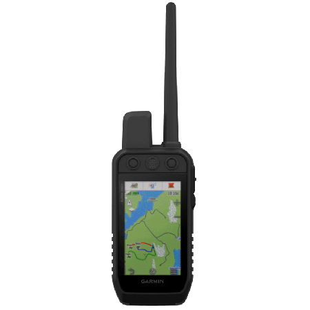
Alpha 200
010-02616-50
Alpha 200i
010-02230-50
Alpha 200 Plus
010-04014-00
Channel 2: 151.88 MHz
Channel 3: 151.94 MHz
Channel 4: 154.57 MHz
Channel 5: 154.60 MHz
|
Alpha 200 010-02616-50 |
Alpha 200i 010-02230-50 |
Alpha 200 Plus 010-04014-00 |
|
| General | |||
| Unit Dimensions | 2.7” x 6.4” x 1.3” (6.8 x 16.2 x 3.4 cm) without antenna | ||
| Weight | 9.9 oz (280 g) with antenna and battery | ||
| Display Size | 1.85" x 3.03" (4.7 x 7.7 cm) | ||
| Display Resolution | 282 x 470 pixels (160 ppi) | ||
| Display Type | 3.5" (8.9 cm) 65K color TFT | ||
| Touchscreen | Yes | ||
| Waterproofing | IPX7 | ||
| Floats | No | ||
| Battery | Removable, Rechargeable 2000 mAh Li-ion battery pack | ||
| Battery Life | 20 hours | 15 hours | 55 hours |
| Integral Battery Charger | Yes | ||
| GNSS Antenna | Quad Helix | ||
| GNSS Chipset | - | ||
| High Sensitivity GNSS Receiver | Yes | ||
| Multi-GNSS | |||
| Multi-Band | No | ||
| GNSS Networks | GPS + Galileo + WAAS/EGNOS | ||
| Iridium Modem | No | SBD | No |
| Interface | micro USB | USB-C | |
| Operating Temperature | -4° to 140°F (-20° to 60°C) | ||
| Charging Temperature | 32° to 113°F (0° to 45°C) | ||
| Storage Temperature | 32° to 77°F (0° to 25°C) | ||
| Maps and Memory | |||
| Basemap | Yes | ||
| Preloaded Map | TopoActive | ||
| Outdoor Maps+ | No | Yes | |
| Ability to Add Maps | Yes | ||
| Garmin Custom Maps | 500 | ||
| Garmin BirdsEye Maps | 250 | ||
| Internal Memory | 16 GB | ||
| Accepts Data Card | Yes (microSD, Max 32GB, Class 4 to 10) | ||
| Custom POIs | Yes | ||
| Waypoints | 10,000 | ||
| Routes | 250 | ||
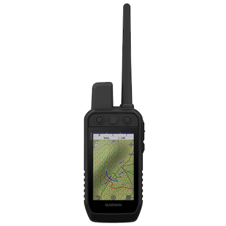
| Tracking | up to 20 assets (any combination of compatible dog devices and handhelds) | ||
| Track Log | 20,000 points, 250 saved gpx tracks, 300 saved fit activities | ||
| Stored Contacts | 250 dogs | ||
| Automatic Routing | Yes | ||
| Sensors | |||
| Electric Compass | Yes (tilt-compensated 3-axis) | ||
| Barometric Altimeter | Yes | ||
| UV Sensor | No | ||
| Microphone | |||
| Outdoor Recreational Features | |||
| Geocaching Friendly | Yes (paperless) - Millions of geocaches (GPX + GGZ) + (GCLive) | ||
| Outdoor GPS Games | No | ||
| Flashlight | |||
| Camera | |||
| Picture Viewer | Yes | ||
| Photo Navigation | |||
| Hunt/Fish Calendar | |||
| Sun/Moon Information | |||
| Area Calculation | |||
| Tide Tables | Yes (with optional Bluechart) | ||
| FM Radio | No | ||
| Multimedia | |||
| Wireless | |||
| Garmin Explore | Yes | ||
| Smart Notifications | |||
| LiveTrack | |||
| Wireless Unit to Unit Transfer | |||
| Connect IQ | |||
| Active Weather | |||
| VIRB Remote | |||
| XERO Locations | |||
| Bluetooth Headset | No | ||
| Radio Features | |||
| Frequency Band | 151-154 MHz (MURS) | ||
| Channels | Channel 1: 151.82 MHz Channel 2: 151.88 MHz Channel 3: 151.94 MHz Channel 4: 154.57 MHz Channel 5: 154.60 MHz |
||
| Transmit Power | 2.0 watts | ||
| Range | 9 miles (TT and T Series), 4 miles (TT mini and T mini Series) | ||
| Location Reporting | Yes | ||
| Contacts | |||
| Vibration Alert | |||
| inReach Features | |||
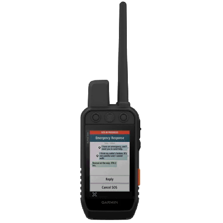
| Interactive SOS Rescue | No | Yes | No |
| inReach Tracking | |||
| inReach Weather | |||
| inReach Messaging | |||
| inReach Remote | Yes | No | Yes |