Features
eTrex 20/30 Features
New Device - Same Name and Quality
- Stores data in universally accepted GPX
file format so its compatible with a variety of PC applications; best
when used with Garmin's free trip planning software,
BaseCamp.
- Includes a worldwide basemap, improved
interface and added support for spine mounting.
- Withstands the elements – be it dust,
dirt, humidity or water.
- Locates your GPS position quickly and
precisely and maintains it even in heavy cover and deep canyons.
- Mounts easily in ATVs, boats, bicycles or
cars (compatible mounts sold separately).
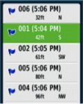
Paperless Geocaching
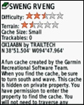 |
Spend more time in the field and less
time fumbling with paper!
The eTrex stores and displays key
information, including location, terrain, difficulty, hints and
descriptions, which means no more manually entering coordinates and
paper print outs.
Simply upload the geocaching GPX file to your unit
and start hunting for caches. |
Track More Satellites
|
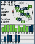 |
Find your way with the first
consumer-grade GPS receiver that tracks both GPS and Russian
Federation GLONASS satellites simultaneously.
When using them
together, the receiver has the ability to lock onto 24 more
satellites than using GPS alone, ensuring you can “lock on” to a
position more quickly. |
User Friendly Layout
|
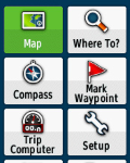 |
Skip the confusion about how to find
things.
eTrex is easy to use with intuitive navigation screens. |
Pick Your Profile
|
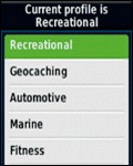 |
Customize eTrex for every occasion.
Profiles allow eTrex to quickly switch into different configurations
that you create, so when you’re done geocaching and you need to
drive home, your eTrex won’t miss a beat.
Read the
Garmin Trail Tech Profiles press release. |
More Dashboards
|
 |
Bring more functionality into your
frequently used applications with dashboards.
Avoid switching
between applications and display more information by customizing
them with an altimeter, compass, configurable data fields and more.
|
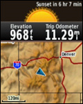
Advanced Tracking
|
 |
Whether following a saved route or
planning a new one, eTrex has the tracking features you need.
Users
can see high and low elevation points or store waypoints along a
track (start, finish and high/low altitude) to estimate time and
distance between points. |
Extensive Map Support
|
 |
With its microSD™ card slot and large
internal memory, eTrex lets you load a variety of maps, including
TOPO 24K, BlueChart® g2, City Navigator NT® and BirdsEye™ Satellite
Imagery (subscription required). |

