Tread SxS
010-02507-00
Tread Overland
010-02508-00
Tread XL Overland
010-02509-00
|
Tread SxS 010-02507-00 |
Tread Overland 010-02508-00 |
Tread XL Overland 010-02509-00 |
|
| General | |||
| Unit Dimensions | 8.1” x 6.7” x 1.2” (20.7 x 16.9 x 3.1 cm) | 9.9” x 7.8” x 1.2” (25.2 x 19.9 x 3.1 cm) | |
| Weight | 22.8 oz (646 g) | 32.8 oz (930 g) | |
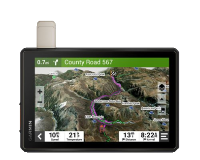
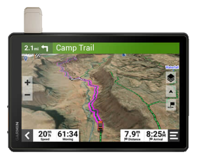
| Display Size | 8.0" (20.3 cm) - 6.8" x 4.2" (17.2 x 10.8 cm) | 10.1" (25.7 cm) - 8.5" x 5.3" (21.7 x 13.6 cm) | |
| Display Resolution | 1280 x 800 pixels | ||
| Display Type | high brightness glass multi-touch HD color TFT with white backlight | ||
| Touchscreen | Yes | ||
| Water / Dust Rating | IP67 | ||
| Drop Rating | MIL STD 810 | ||
| Floats | No | ||
| Battery | Internal Rechargeable Lithium-ion | ||
| Battery Life | up to 6 hours at 50% backlight, up to 1 hour at 100% backlight | ||
| Operating Temperature | -4° to 131°F (-20° to 55°C) | ||
| Charging Temperature | 32° to 113°F (0° to 45°C) | ||
| External Power Input | 12v - 24v DC | ||
| Mount | Locking Magnet Assisted with 1.5" Ball Adapter AMPS Plate | ||
| Iridium Antenna | Quad Helix | ||
| GPS Antenna | Internal Patch | ||
| GPS Chipset | - | ||
| High Sensitivity GPS Receiver | Yes | ||
| Multi-GNSS | |||
| Multi-Band | No | ||
| GNSS Network | GPS + Galileo | ||
| Iridium Modem | SBD | ||
| Interface | USB-C | ||
| Memory | |||
| Internal Memory | 64GB | ||
| Accepts Data Card | Yes (microSD, Max 256GB, Class 2 to 10) | ||
| Custom POIs | Yes | ||
| Waypoints | 8,500 | ||
| Routes | ∞ | ||
| Tracks | 2,000 (250,000 Track Points Each) | ||
| Maps | |||
| Preloaded Maps | Street Maps | ||
| Topographical Maps | |||
| US Public Land Boundaries | |||
| Private Land Parcel Maps | |||
| USFS Roads and Trails | |||
| MVUM Maps for Motorcycle, ATV, SxS and Full Size 4x4 | |||
| High Definition 3D Terrain Maps | |||
| Outdoor Maps+ | Yes | ||
| Ability to Add Maps | |||
| Garmin Custom Maps | 400 | ||
| Garmin BirdsEye Maps | 1,000 | ||
| Sensors | |||
| Electric Compass | Yes | ||
| Barometric Altimeter | |||
| 10Hz Multi-GNSS Positioning | |||
| UV Sensor | No | ||
| Microphone | |||
| Outdoor Recreation Features | |||
| Point-To-Point Navigation | |||
| Navigate-A-Track Navigation | |||
| Turn-By-Turn Trail Navigation | |||
| Navigation Features | |||
| Garmin Real Directions Landmark Guidance | |||
| TripAdvisor Traveler Ratings | |||
| Route Shaping Through Preferred Cities/Streets | |||
| Traffic Information | |||
| Lane Assist With Junction View | |||
| Speed Limit Indicator | |||
| Driver Alerts for Sharp Curves, School Zones, Red Light and Speed Cameras, and More | |||
| Motorcycle Features | |||
| Glove-Friendly Touchscreen | |||
| Control Music and Media from Smartphone or MP3 Player | |||
| Sunlight Readable and Weather Resistant | |||
| Garmin Adventerous Routing | |||
| Motorcycle and Powersports Specific Points of Interest | |||
| Elevation Profile | |||
| Round Trip Routing | |||
| Service History Log | |||
| Custom Map Support | |||
| Topo Map Support | |||
| RV Features | |||
| Specialized Routing for Vehicle Size and Weight | |||
| RV Parks and Services Directory | |||
| Road Elevations | |||
| Speed Limit Changes | |||
| Easy Route Planner with GPX File Sharing | |||
| Adventure Features | |||
| Built-In inReach Technology (Requires Subscription) | |||
| Pair with Garmin PowerSwitch | |||
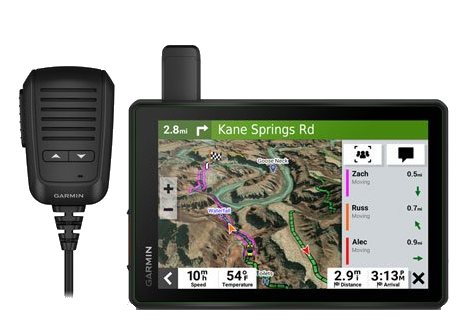
| Compatible with Group Ride Radio | |||
| Group Ride Mobile | |||
| Compatible with External GPS Antenna | |||
| Compatible with External inReach Satellite Antenna | |||
| Track Recorder (Breadcrumb Trail) | |||
| IOverlander Points of Interest | |||
| Ultimate Public Campgrounds | |||
| Pitch and Roll Gauges | |||
| BirdsEye Satellite Imagery | |||
| Advanced Features | |||
| Smart Notifications Via APP | |||
| Wi-Fi Map and Software Updates | |||
| Access To Live Services Via APP (Traffic, Weather, Etc.) | |||
| inReach | |||
| inReach SOS Rescue | Yes | ||
| inReach Tracking | |||
| inReach Messaging | |||
| inReach Weather | No | ||
| inReach Remote | |||
| Wireless | |||
| Backup Camera Compatible | BC 50 | ||
| Bluetooth Calling | Yes | ||
| Wi-Fi Updates | |||
| Garmin Connect App | No | ||
| Garmin Explore App | |||
| Garmin Tread App | Yes | ||
| Smart Notifications | |||
| Live Tracking | Yes (via Group Ride Radio or Tread App) | ||
| Wireless Unit to Unit Transfer | Yes (via Group Ride Radio) | ||
| Connect IQ Applications | No | ||
| Live Weather | Yes | ||
| Dog Tracking | |||
| VIRB Remote | No | ||
| XERO Locations | |||
| RINEX Logging | |||
| Group Ride Radio | |||
| FCC License Required | No | Optional Accessory | |
| Radio Frequency Band | MURS (151-154 MHz) | ||
| Group Ride Range | typically 1 mile | ||
| Group Ride Tracking | up to 20 riders simultaneously | ||
| Group Ride Update Rate | 2.5 seconds | ||
| Group Ride Voice Communications | Yes (with fist mic or bluetooth headset) | ||
| Radio Transmitted Canned Messages | Yes | ||