What is QZSS?
- The Quasi-Zenith Satellite System is a satellite-based augmentation system (SBAS) developed by the Japanese government.
- The main focus of QZSS is to enhance the United States operated Global Positioning System (GPS) in the Asia-Oceania regions.
- QZSS is also known as 'Michibiki' - which means 'guide' or 'show the way'.
QZSS Operation
-
The QZSS concept is quite unique when compared to the similar arrangements
shared by GPS,
GLONASS and Galileo.
- QZSS is designed to augment another satellite navigation system (GPS).
- QZSS satellites occupy inclined elliptical geosynchronous (Tundra) orbits for optimal high-elevation visibility in the coverage area.
- QZSS uses a total of seven satellites, four in quasi-zenith orbit (QZO), two in geostationary orbit (GEO), and one in quasi-geostationary orbit.
- Primarily intended to increase GPS availability in Japan's numerous urban canyons, where only satellites at very high elevations are visible.
- Secondary functions include performance enhancements increasing the accuracy and reliability of GPS derived navigation solutions.
- All Quasi-Zenith Satellites transmit signals compatible with the GPS L1C/A signal, as well as the modernized GPS L1C, L2C and L5 signals.
- GPS + QZSS delivers improved positioning performance and improved reliability when compared to GPS alone.
- QZSS receivers can resolve ionospheric errors by combining multiple frequencies (L1 with L2 or L5).
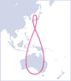

QZSS Tundra Orbit
QZSS Services
- The QZSS system will provide the following services:
- Satellite Positioning Service - Provide service similar to GPS with improved coverage in urban and mountain areas.
- Sub-Meter Level Augmentation Service - Improved accuracy positioning in the 2-3 meter range.
- Centimeter Level Augmentation Service - Highly accurate positioning in the 10 centimeter range.
- Position Technology Verification Services - Will provide an application demonstration for new positioning technology.
- Short Message Delivery Service - Provides users in the field with rescue, disaster and crisis management services.
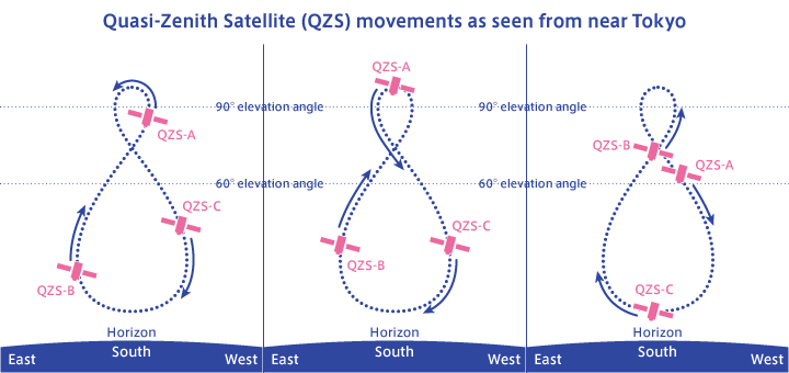
QZSS Coverage
- The QZSS constellation consists of three satellites in a periodic Highly Elliptical Orbit (HEO) with a fourth satellite in a geo-stationary orbit.
- All three HEO satellites follow the same path so that at least one of them is always near the zenith over Japan ('quasi-zenith').
- When viewed from Tokyo, these satellites will remain overhead with an elevation:
- above 70° for 8 hours each day.
- above 50° for 12 hours each day.
-
above 20° for 16 hours each day.
-
QZSS can be used in any Asia-Oceania region with a longitude close to
Japan:

Hours per day at least one QZSS satellite is above 40° elevation
QZSS Availability
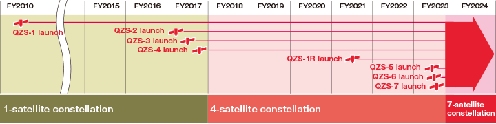
- QZSS service officially started on November 1, 2018 with a four satellite constellation.
- A fully independent QZSS service consisting of
seven satellites was planned for 2023.
- View a list of available QZSS satellites. (status)
- Choose desired QZSS Satellite (NMEA ID) below to view current location:
Do I Need QZSS?
- Many modern GPS receivers (GPSr) are able to use both QZSS and GPS satellites.
- Simultaneous use of QZSS and GPS provides improved coverage, performance and reliability when compared to GPS alone.
- For locations in or near Japan, the benefits of using QZSS while navigating urban canyons or mountainous areas are undeniable.