 |
|
|
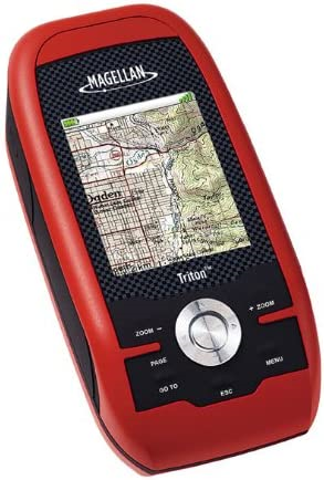
The new Magellan Triton 500 is built tough, with the
latest hardware - yet its simple software interface is a
snap to operate. Amazingly easy to use, Triton 500 is
perfect for the first-time GPS user. And the full-color
display, SD-card compatibility, enhanced features, fast
signal acquisition, reliable signal lock and precision
positioning make Triton 500 an excellent choice for the
advanced navigator. The Triton 500's 3-axis electronic
compass and built-in barometer offer enhanced navigation
capabilities as well. The smartly designed interface with simple menus and intuitive button and scroll pad control make navigation fun and effortless. The full-color crystal clear display shows all your maps and navigation information in brilliant, easy-to-view graphics. Instantly see all your maps, locations and saved tracks and waypoints with just a click or two. Unlike other complicated devices that require you to scroll through page after page, Triton 500 gets you to the information you want with a few keystrokes. SD-card compatibility maximizes your navigation capability. Add an unlimited amount of marine cartography, topographic maps and other content to navigate all your outdoor adventures. Plus, Triton is the first handheld GPS to offer compatibility with National Geographic maps. These highly detailed nation-wide topographic maps are based on USGS 1:24.000 series quads, offer seamless scalability with customizable multi-layer overlays and much more. Exclusive VantagePoint software enables easy management of maps, user generated content, updates and upgrades on your PC. View saved routes and tracks. Customize them for future trips or create new ones. Triton is designed for precision navigation, offering the fastest GPS positioning acquisition in the industry with the SiRFstar III chipset. An integrated high-sensitivity antenna provides reliable signal reception even in heavy cloud cover, canyons or deep woods. Built-in signal augmentation reception (WAAS/EGNOS) provides 3-meter accuracy. Rugged and waterproof, your Triton 500 is built to withstand intense use, accidental impacts and immersion in one meter of water for up to 30 minutes (IPX-7). It's ready to guide you on any adventure. The advanced features are also easy to use. View the elevation profile for the trail ahead (or any route) or even the track you just traveled. See the precise time of sunrise/sunset any day of the year. Get a calculation of the best hunting and fishing time. And much more. Triton is built on the experience of hundreds of thousands of GPS users and nearly 20 years of precision positioning technology from Magellan. Triton 500: find inspiration in exploration! |
- Amazing ease-of-use - Reinventing
handheld GPS, simple menus, instant access buttons,
intuitive keypad and crystal clear graphics let you navigate
without the need for a Ph.D.
- 3-axis electronic compass - Clearly see
your direction no matter how you hold your GPS, even when
standing still
- Barometer - Sensitive barometric
pressure readings offer advance notice of changing weather
and assists in providing accurate elevation
- Full-color 2.2" display - The large
display shows maps, simple menus, navigation screens and
other data in brilliant color
- SD-card compatibility - An invaluable
feature enables you to use an unlimited amount of map data
for topographic, marine and vehicle navigation. Store
tracks, routes, geocaches and more
- Add detailed maps - Upload optional
marine cartography, topographic maps, and more, including
the highly-detailed and feature-packed National Geographic
TOPO! State series and Weekend Explorer 3D maps to your OWN
SD cards
- Built-in maps - Basemap of the 48
contiguous United States, Alaska, and Canada (major
highways, city centers, bodies of water and more) plus
worldwide geographic boundaries
- 3-meter accuracy - SiRFstar III chipset
and integrated multidirectional antennae offer superior GPS
accuracy using the Wide Area Augmentation System (WAAS)
- Access to Main Menu From Any Navigation Page - The ability to access the Main Menu (Go To, Create, View) from any Navigation Page.
- Improved Track Management - The ability to Start, Stop, Resume Track from the contextual menu.
- Improved Route Management - The ability to Go To Next or Go To Previous point while in an active route.
- User Grid Coordinate System (Based on Additional Coordinate Systems) - Added customizable User Grid functionality based on additional coordinate system, including Lambert Conic, Stereograph, Oblique Mercator, UTM, and Polyconic.
- Area Calculation - The ability to calculate an area based on active track, saved trails, and saved routes.
- Added optional Navigation Fields to Map screen for Triton 300/400/500 devices.
- Added Quick Info on Map screen.
- Contextual menu improvement.
- Power Saving - reduce backlight if battery level is 50% or lower.
- Electronic Compass User Calibration UI improvement.
- Move low-level settings (e.g., time zone and power timer settings) from the Profiles to Settings.
- Add additional settings to Profile.
- New Coordinate and Elevation Entry UI.
- New Strip Compass Navigation screen.
- New Road Navigation screen.
- User Grid (Trans. Mercator only).
- Coordinate Fields display on the Info pages.
- User Object Selection improvement.
- Option to clear active track after trail was created.
- Option to turn ON/OFF Navigation Screens.