 |
|
|
The Magellan Triton 2000 is unlike any handheld GPS
system you've even seen, heard, or felt. It's the first
consumer-grade outdoor GPS device with a touch-screen
interface, fully integrated microphone and speaker, MP3
player, LED flashlight, digital camera, barometer and
3-axis compass all crammed into a compact and affordable
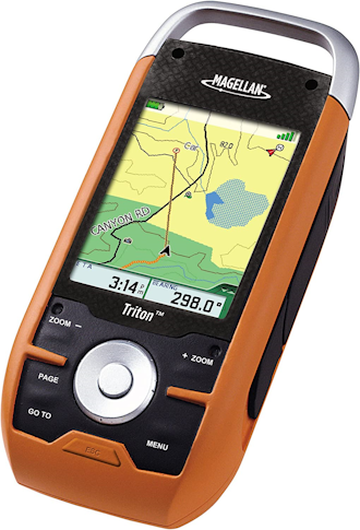
package. Amazingly easy to use, the Triton 2000 reinvents handheld GPS. A large, 2.7" color touch screen makes it easy to navigate the simple, intuitive menus and control navigation features with a touch. Use Magellan's exclusive VantagePoint software to easily manage and upload detailed maps, user generated content, updates and upgrades on your PC. View saved routes and tracks, then customize them for future trips or create new ones. SD-card compatibility makes it easy to expand your navigation capabilities by adding detailed maps and applications. Upload optional detailed topographic maps, marine cartography, and other applications to find your way on all your outdoor adventures. Plus, Triton is the first handheld GPS to offer compatibility with National Geographic maps. These highly detailed nation-wide topographic maps based on USGS 1:24,000 series quads, offer seamless scalability, multi-layer overlays and much more. Use the 2 mega pixel camera to capture images of your journey. Snap a shot of the amazing view, your adventuring companions and your found geocache or favorite campsite to attach to a waypoint or just to capture the moment. Share your images with friends and family, download the pictures to your PC for posting to the Web, email friends and family or create prints. Record audio notes for waypoints and play them back with the built-in microphone and speaker. A powerful, low battery consumption LED flashlight helps you find your way in the dark: an invaluable tool for camping and other outdoor recreation. Additional advanced features include a 3-axis electronic compass and built-in barometer. The electronic compass shows your direction even when standing still and no matter how you hold the unit. The barometer gives you advance notice on the changing weather and helps provide a highly accurate elevation reading. Triton is designed for precision navigation, offering the fastest GPS positioning acquisition in the industry with the SiRFstar III chipset. An integrated high-sensitivity antenna provides reliable signal reception even in heavy cloud cover, canyons or deep woods. Built-in signal augmentation reception (WAAS/EGNOS) provides 3-meter accuracy. Rugged and waterproof, your Triton is built to withstand intense use, accidental impact and immersion in one meter of water for up to 30 minutes (IPX-7). It's ready to guide you across any terrain in the great outdoors. Touch-screen technology makes it easy to use all the advanced features. View the elevation profile for the trail ahead (or any route) or even the track you just traveled. See the precise time of sunrise/sunset any day of the year. Get a calculation of the best hunting and fishing time. And much more. Triton is built on the experience of GPS users and nearly 20 years of precision positioning technology from Magellan. Triton 2000: turn the outdoors into your own backyard! |
- 2.7" color touch screen control - The
latest touch-screen technology is built in to the large
brilliant color display. Control navigation and advanced
features with a touch
- Amazing ease-of-use - Reinventing
handheld GPS, simple menus, instant access buttons,
intuitive keypad and crystal clear graphics let you navigate
without the need for a PH.D.
- 2 MP camera - Take clear beautiful
pictures of your adventure as you navigate to attach them to
waypoints so you can easily find your way back to the same
spot or just to share with family and friends
- Voice recorder - Microphone and speaker
enable you to record audio notes for waypoints to share with
friends and family or easily find your way back next time
- Flashlight - Light your way with a
powerful LED flashlight. Low power consumption helps
maximize battery life
- 3-axis electronic compass - Get an
accurate compass reading even while standing still and no
matter how you hold the unit
- Barometer - Sensitive barometric
pressure readings offer advance notice of changing weather
and assists in providing accurate elevation
- SD-card expansion - Use your own SD
memory cards to upload unlimited detailed maps and store
routes, waypoints, geocaches and more
- Built-in maps - Basemap of the 48
contiguous United States, Alaska, and Canada (major
highways, city centers, bodies of water and more) plus
worldwide geographic boundaries
- Add detailed maps - Upload optional
marine cartography, topographic maps, and more, including
the highly-detailed and feature-packed National Geographic
TOPO! State series and Weekend Explorer 3D maps to your OWN
SD cards
- 3-meter accuracy - SiRFstar III chipset
and integrated multidirectional antennae offer superior GPS
accuracy using the Wide Area Augmentation System (WAAS)
- Digital music player - Upload your
digital music to your OWN available memory or own SD card
and enjoy a customized soundtrack as you explore. Plug in
any standard headphones for clear private listening
- External antenna connector - Simply
plug in an external antenna in your boat or off-road vehicle
for enhanced GPS signal reception
- Audio jack - Plug in any standard 1/8"
headphones to enjoy clear private listening of your digital
music, voice notes and other recordings
- Access to Main Menu From Any Navigation Page - The ability to access the Main Menu (Go To, Create, View) from any Navigation Page.
- Improved Track Management - The ability to Start, Stop, Resume Track from the contextual menu.
- Improved Route Management - The ability to Go To Next or Go To Previous point while in an active route.
- User Grid Coordinate System (Based on Additional Coordinate Systems) - Added customizable User Grid functionality based on additional coordinate system, including Lambert Conic, Stereograph, Oblique Mercator, UTM, and Polyconic.
- Area Calculation - The ability to calculate an area based on active track, saved trails, and saved routes.
- New North America basemap.
- New Map selection user interface.
- Support for National Geographic TOPO! Explorer SuperQuad maps.
- Ability to turn the basemap ON & OFF on the unit.
- Improved cartography and symbols, such as Points of Interest icons.
- Improved overall system performance, including multimedia, translation, and map display.
- Added True Magnetic North indicator on map screen.