| While the shortest distance between two points is a straight line, in the great outdoors rarely is the straight line an option. For many customers, navigating a saved track is the best option for providing guidance along a desired trail. Tracks are great because they allow incredible clarity and detail of the predetermined path. | |||
 |
 |
 |
 |
| If you are planning a trip, consider
using Garmin’s free outdoor trip planning software BaseCamp. This
desktop application provides a simple freehand track drawing
utility, allowing users to create tracks in seconds and send them to
a Garmin device. Another option is to explore the millions of
activities from other Garmin users at Garmin Connect. If someone
else has already completed the same trail for your trek, Garmin
Connect allows you to export an activity as a GPX file to your
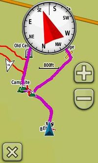
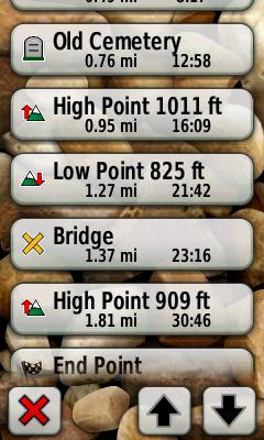
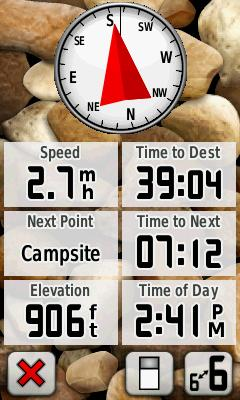
device. With the latest firmware for Oregon and Dakota devices, your device can provide a better navigation experience than before. We’ve added automatic detection of high and low points using elevation stored in the saved track. These points are added to the map and listed on the active route page. If you have significant landmarks, campsites, trailheads, restrooms, or other points saved as waypoints, our new track navigation includes all waypoints located along the track and lists them on the active route page. Listing these waypoints alongside high and low points combines the clarity of saved tracks with the landmarks of traditional routes. Data fields can be selected to provide the distance to, time en route, arrival time, or name of the next point (high point, low point, or waypoint) or destination.
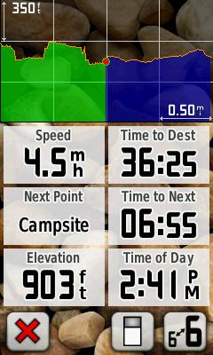
For treks with the added vertical challenge, our new future plot feature not only shows an elevation profile of the adventure so far, but also what is ahead. When navigating saved tracks that include elevation data in the track points, the future plot is added in blue to the historic elevation profile in green. This elevation profile can now be added to the trip computer, compass page, or map page using the new Elevation Plot dashboard. |
|||