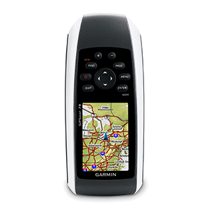
GPSMAP 78
010-00864-00
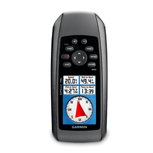
GPSMAP 78s
010-00864-01
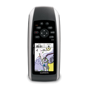
GPSMAP 78sc
010-00864-02
|
GPSMAP 78 010-00864-00 |
GPSMAP 78s 010-00864-01 |
GPSMAP 78sc 010-00864-02 |
|
| General | |||
| Unit Dimensions | 2.6” x 6.0” x 1.2” (6.6 x 15.2 x 3.0 cm) | ||
| Weight | 7.7 oz (218.3 g) with batteries | ||
| Display Size | 1.43" x 2.15" (3.6 x 5.5 cm) | ||
| Display Resolution | 160 x 240 pixels (110 ppi) | ||
| Display Type | 2.6" 65K color TFT | ||
| Touchscreen | No | ||
| Waterproofing | IPX7 | ||
| Floats | Yes | ||
| Battery | 2 AA (NiMH or Lithium recommended) | ||
| Battery Life | 20 hours | ||
| Integral Battery Charger | No | ||
| GPS Antenna | Patch | ||
| GPS Chipset | |||
| High Sensitivity GPS Receiver | Yes | ||
| GNSS Network | GPS + WAAS/EGNOS | ||
| Interface | mini USB | ||
| Operating Temperature | 5° to 158°F (-15° to 70°C) | ||
| Maps and Memory | |||
| Basemap | Yes | ||
| Preloaded Map | No | Yes | |
| Ability to Add Maps | Yes (3000 map segments) | ||
| Garmin Custom Maps | Yes (100 custom map tiles) | ||
| Garmin BirdsEye Maps | Yes (250 BirdsEye imagery files) | ||
| Internal Memory | 1.7 GB | 3.7 GB | |
| Accepts Data Card | Yes (microSD, Max 32GB, Class 4 to 10) | ||
| Custom POIs | Yes | ||
| Waypoints | 2000 | ||
| Routes | 200 | ||
| Track Log | 10,000 points, 200 saved tracks, 2000 archive tracks | ||
| Automatic Routing | Yes (with optional mapping for detailed roads) | ||
| Sensors | |||
| Electric Compass | No | Yes (tilt-compensated 3-axis) | |
| Barometric Altimeter | Yes | ||
| UV Sensor | No | ||
| Microphone | |||
| Outdoor Recreational Features | |||
| Geocaching Friendly | Yes (Paperless) - 5,000 geocaches | ||
| Outdoor GPS Games | No | ||
| Flashlight | |||
| Camera | No | ||
| Picture Viewer | Yes | ||
| Photo Navigation | |||
| Hunt/Fish Calendar | |||
| Sun/Moon Information | |||
| Area Calculation | |||
| Tide Tables | Yes (with optional Bluechart) | ||
| Radio | No | ||
| Multimedia | |||
| Wireless | |||
| Garmin Connect | No | ||
| Smart Notifications | |||
| LiveTrack | |||
| Wireless Unit to Unit Transfer | No | Yes | |
| Connect IQ | No | ||
| Active Weather | |||