
- Use the Satellite application to view:
- GPS coordinates
- GPS elevation
- GPS accuracy
- GPS satellite locations
- GPS satellite signal strength
- Current device heading
Satellite Information
- There's more information available on the Satellite page beyond current location, accuracy and elevation.
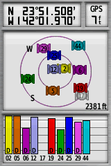
Satellite Map
- Determine satellite location relative to your current position:
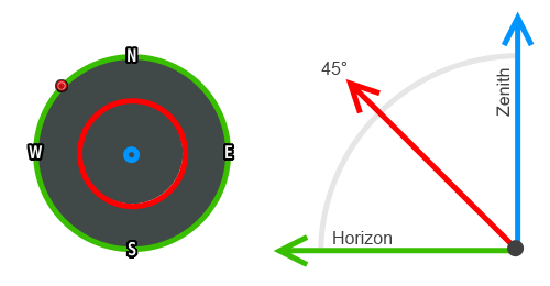 |
- Zenith: Satellites located directly overhead provide better accuracy when calculating vertical position.
- Elevation: Most visible satellites are found midway in the sky and are best used to determine horizontal position.
- Horizon: Satellites near the horizon are more sensitive to geographic obstructions and therefore less reliable.
-
 :
Dynamic heading indicator displayed when configured for 'North Up'.
:
Dynamic heading indicator displayed when configured for 'North Up'.
Signal Strength
- Satellite signal acquisition sequence and signal:noise ratio status:
 |
 |
 |
|
|||||
|---|---|---|---|---|---|---|---|---|
 |
 |
 |
 |
|||||
| ===== |
===== |
===== |
||||||
| A | B | C | D |
- A: Searching for a known satellite signal.
- B: Satellite signal located, downloading data.
- C: Satellite data contributing to location calculation.
- D: SBAS information has been applied and satellite signal is Differentially corrected.
Satellite Page Display
- GPS, GPS + WAAS/EGNOS and Demo Mode can be enabled/disabled in [Setup > System > GPS].
 |
 |
 |
 |
|---|---|---|---|
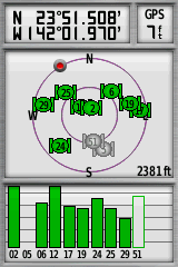
| GPS North Up Single Color |
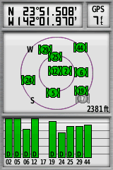
GPS Track Up Single Color WAAS/EGNOS |
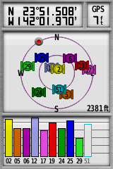
GPS North Up Multicolor |
GPS Track Up Multicolor WAAS/EGNOS |
Option Menu
- Press (MENU) to open the Satellite page option menu:
- Use With GPS Off - Disables GPS and enables Demo Mode.
- Set Location On Map - Choose desired location for GPS simulation.
-
Autolocate Position - Clears existing
satellite almanac and begins a new search for available signals.
-
Use With GPS On - Disables Demo Mode and enables
GPS.
- Track Up - The satellite map compass will display the current heading centered at the top of the screen.
-
North Up - The satellite map compass is locked 'north up' with serving as a dynamic heading indicator.
- Single Color - All satellite icons and signals are displayed using the default color.
- Multicolor - Each satellite icons and signal is displayed using a unique color.