| Error Reporting | |||
|
|||
| Status | |||
|
|||
| Categories | |||
|
|||
| Bugs | |||
| 1. | Map page Map Layers menu selections can not be toggled independently when only Satellite and TopoActive options are available. [Gr] | (558) | [440] [470] |
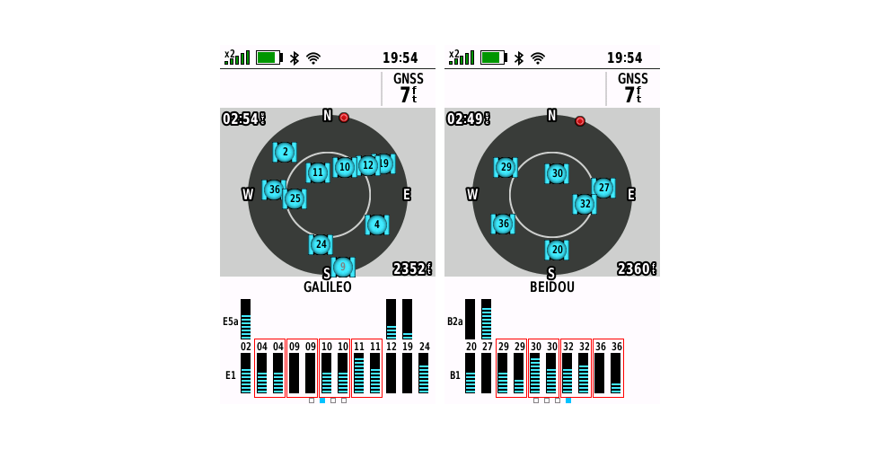
| 2. | Satellite signal bars are frequently duplicated on Satellite page for both Galileo and BeiDou constellations. [example] | (542) | [440] [470] [480] [530] |
| 3. | After opening the Map page and selecting (Menu) > [Download Maps Here], the user is frequently returned to the Map page instead of the Map Download page once a Wi-Fi connection has been established. | (579) | [440] [470] [480] [530] |
| 4. | Users may randomly discover that both 'Multi-GNSS' and 'Multi-Band' have been disabled in [Setup > System] without their consent. [Gr] | [440] [470] [480] [530] [590] [660] [760] [830] [850] [880] [890] [910] [920] [934] [935] [938] [940] [945] [946] | |
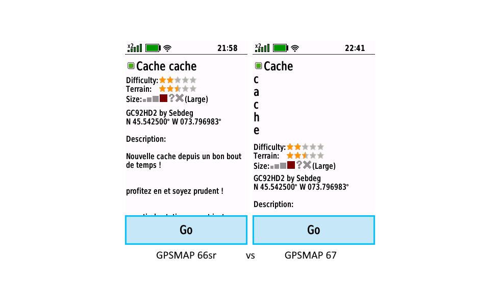
| 5. | The last word in some geocache names may be incorrectly displayed vertically on the GPSMAP 67 while the exact same GPX file is displayed properly on previous models. [example] [Gr] | (601) | [440] [470] [480] [530] |
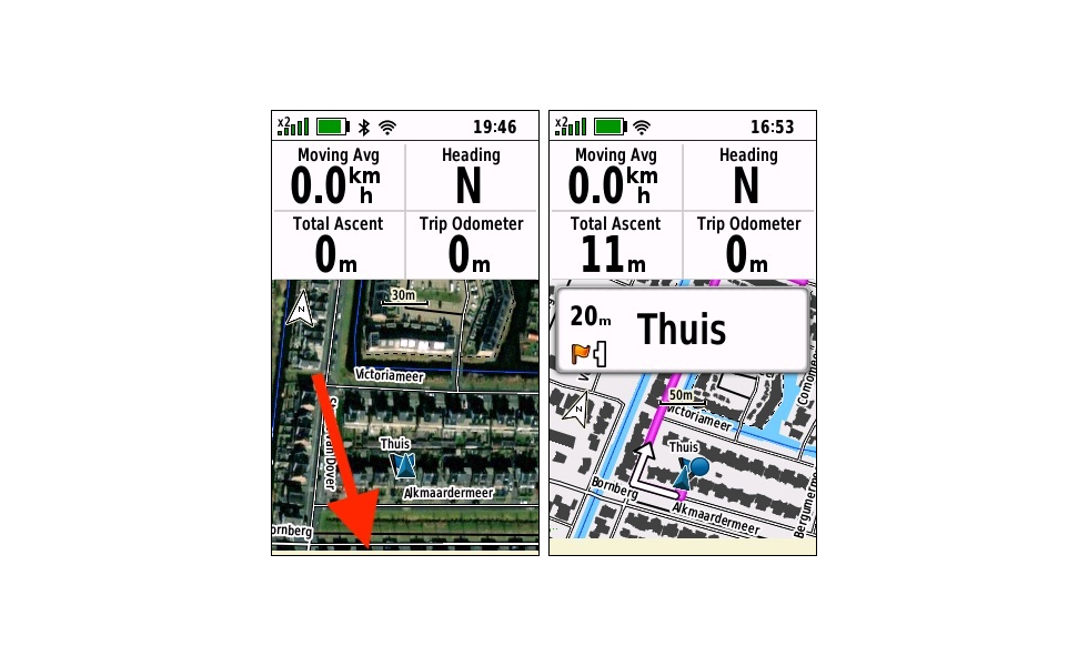
| 6. | The 'Distance to Next' and 'Distance to Destination' data fields do not perform as expected. [Gr] | (604) | [440] [470] [480] |
| 7. | After Wi-Fi is disabled by the user and no Wi-Fi symbol is displayed in the status bar, an active Wi-Fi connection is maintained, even after restarting the device, providing the user with a false impression that Wi-Fi has been disabled and the device is not connected to a wireless network. [Gr] | (612) | [440] [470] [480] [530] [590] [660] [760] [830] [850] [880] [890] [910] [920] [934] [935] [938] [940] [945] [946] |
| 8. | GNSS location accuracy may drift and/or fail to recover after exiting heavy cover. [example] [example] [example] [Gr] | (734) | [440] [470] [480] [530] [590] [660] [760] [830] [850] [880] [890] [910] [920] [934] [935] [938] [940] [945] [946] |
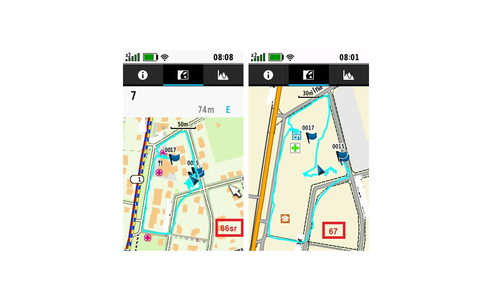
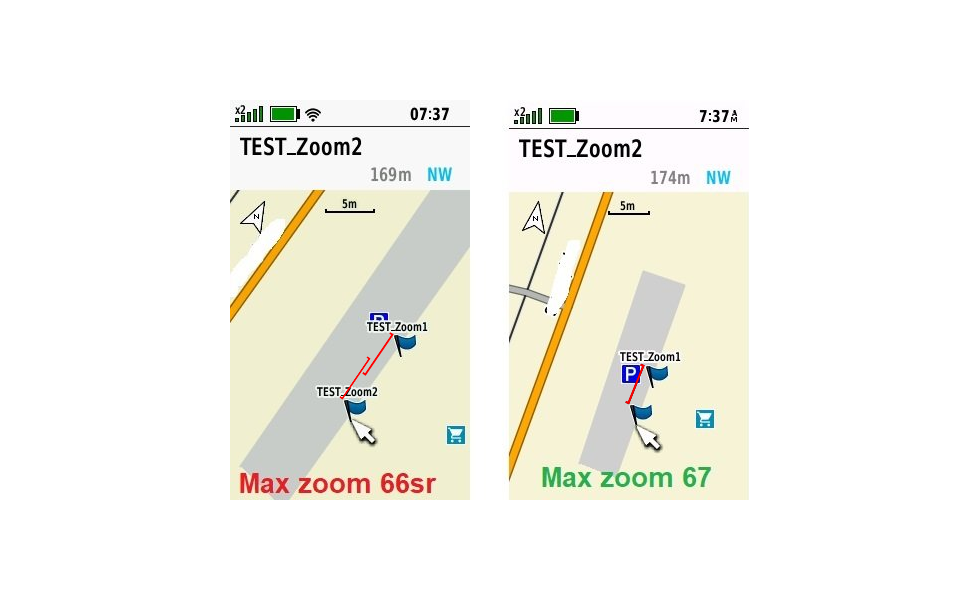
| 9. | Map page information may not be displayed correctly for the selected scale. [example] [example] [Gr] | (618) | [440] [470] [480] [530] [590] [660] [760] [830] [850] [880] [890] [910] [920] [934] [935] [938] [940] [945] [946] |
| 10. | The Map page dashboard is frequently reset to 'Show Dashboard' status without user request after 'Hide Dashboard' has been selected in the Map page option menu. [Gr] | (608) | [440] [470] [480] [530] |
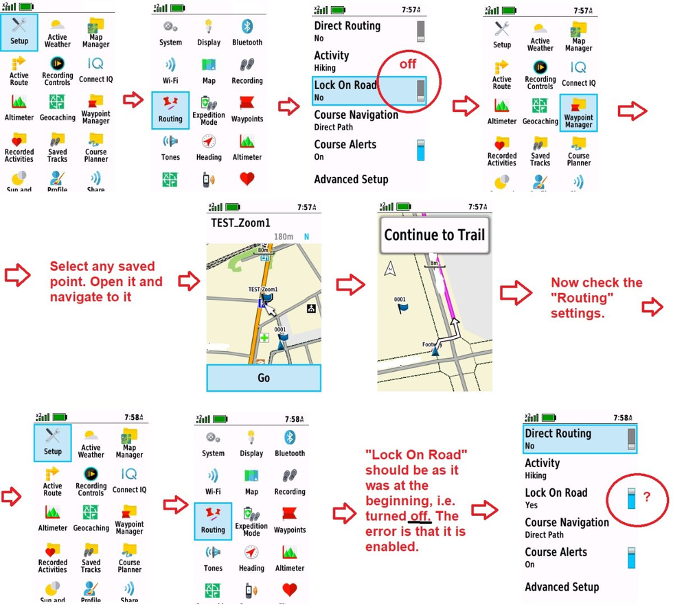
| 11. | [Setup > Routing > Lock on Road] is frequently changed from 'No' to 'Yes' without user intervention. [example] [Gr] | (613) | [440] [470] [480] [530] |
| 12. | The 'inReach Remote' page is not available when configuring the Page Ribbon sequence. [Gr] | (653) | [440] [470] [480] [530] [590] [660] [760] [830] [850] [880] [890] [910] [920] [934] [935] [938] [940] [945] [946] |
| 13. | The lower edge of the Map page may not be fully rendered when a dashboard is enabled and/or when navigation guidance text is displayed. [example] [Gr] | [440] [470] [480] [530] [590] [660] [760] [830] [850] [880] [890] [910] [920] [934] [935] [938] [940] [945] [946] | |
| 14. | LiveTrack feature fails to update user location and data. [Gr] | (630) | [440] [470] [480] [530] |
| 15. | User is unable to pan and zoom when reviewing downloaded Outdoor Maps+ map sets after installing update v5.30. | [530] [590] [660] [760] | |
| 16. | After attempting to pan and zoom the map while reviewing any Outdoor Maps+ map set, the user is no longer able to change the Map page zoom level without first restarting the device. | (661) | [530] [590] |
| 17. | Selecting LiveTrack tile on Status Page and pressing (Enter) only returns the user to the Main Menu. | (662) | [530] [590] |
| 18. | With [Setup > Tracking > Link with Recording = On], inReach Tracking fails to begin the first time an Activity Recording is started follwing a device power cycle. [garmin] | [530] [590] [660] [760] [830] [850] [880] [890] [910] [920] [934] [935] [938] [940] [945] [946] | |
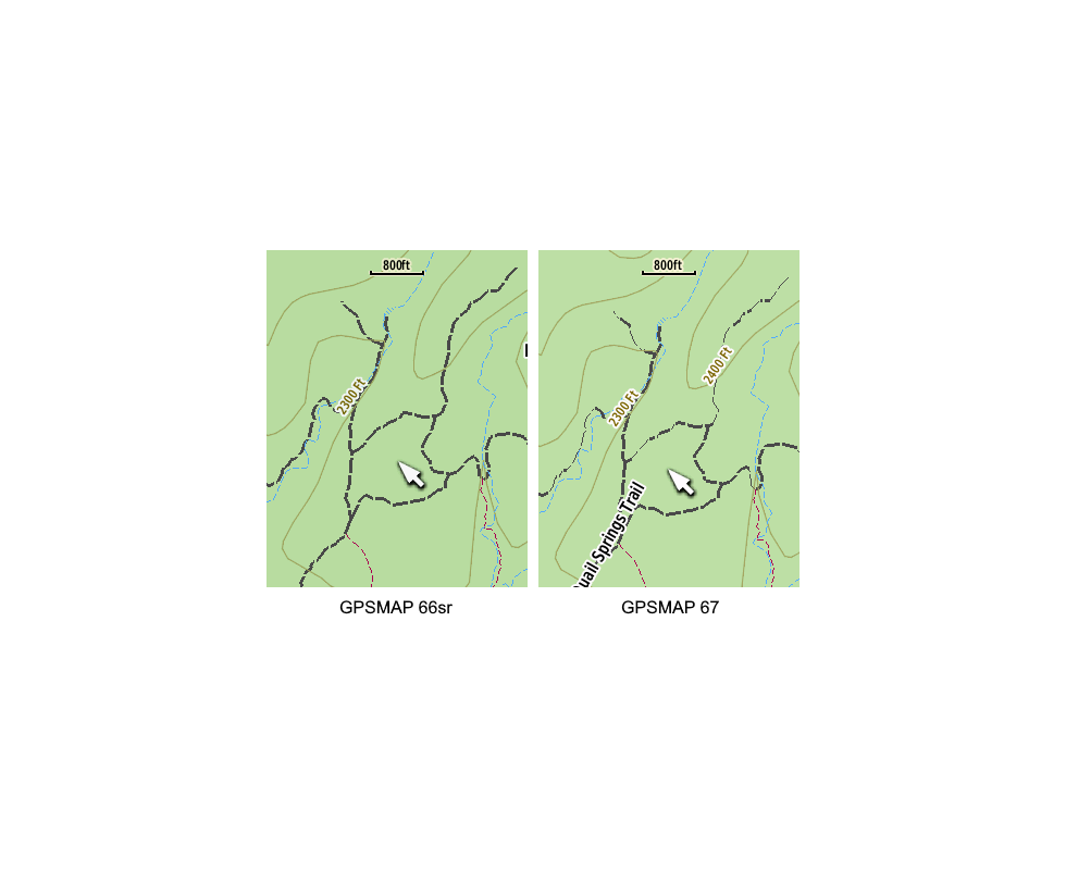
| 19. | Some Garmin TopoActive Map details may not be rendered properly. [example] | (671) | [530] [590] |
| 20. |
Wi-Fi networks are removed from list after a failed connection.
[Gr] 1. Open [Setup > Wi-Fi]. 2. Add a Wi-Fi network. 3. Disable Wi-Fi network (power router off, etc.) 4. Configure [Setup > Expedition Mode = Prompted]. 5. Press the (Power) button until "Enter Expedition Mode?" appears. 6. Select [Expedition Mode] and press (Enter). 7. Press the (Power) button to wake up the device. 8. Open [Setup > Wi-Fi] and select the previously added Wi-Fi network and press (Enter). 9. Select [Connect] and press (Enter). 10. A "Failed to connect to Network {Name}" message will appear. You can only select [OK] at this point. 11. Select [OK] and press (Enter). 12. The Wi-Fi network is removed from the list. |
(700) | [530] [590] [660] [760] [830] [850] [880] [890] [910] [920] [934] [935] [938] [940] [945] [946] |
| 21. | Expedition Mode Recording Interval is reset to '10 Minutes' after each device power cycle. | (701) | [530] [590] [660] |
|
22. |
Files disabled in [Map] > (Menu) > [Geocache Filter > Geocache Files] are always reset to enabled status the next time the Geocache Filter menu is opened. [Gr] | (704) | [530] [590] [660] [760] [830] [850] [880] [890] [910] [920] [934] [935] [938] [940] [945] [946] |
| 23. | The waypoint editing menu workflow and menu selection process may be very slow to respond. [Gr] | [530] [590] [660] [760] [830] [850] [880] [890] [910] [920] [934] [935] [938] [940] [945] [946] | |
| 24. | After opening the Waypoint Manager page and selecting any waypoint, pressing (Enter) > (Menu), selecting [Delete] and pressing (Enter) results in the Geocache Page being displayed. Pressing (Quit) leaves the user in the Geocache page. | [530] [590] [660] | |
| 25. | After opening the Waypoint Manager page and selecting any waypoint, pressing (Enter) > (Menu), selecting [Delete] and pressing (Enter) results in the Geocache Page being displayed. Selecting [Delete] and pressing (Enter) leaves the user in the Geocache page without deleting the waypoint. | [530] [590] [660] | |
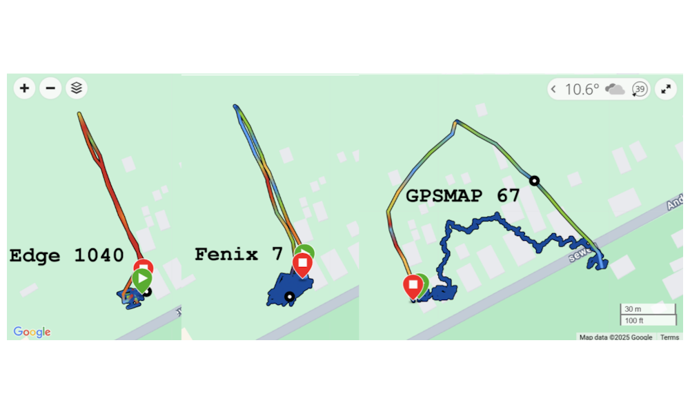
| 26. | Activity recordings may loose elevation over time compared to simultaneous recordings from similar devices. [example] | (725) | [590] [660] [760] [830] [850] [880] [890] [910] [920] [934] [935] [938] [940] [945] [946] |
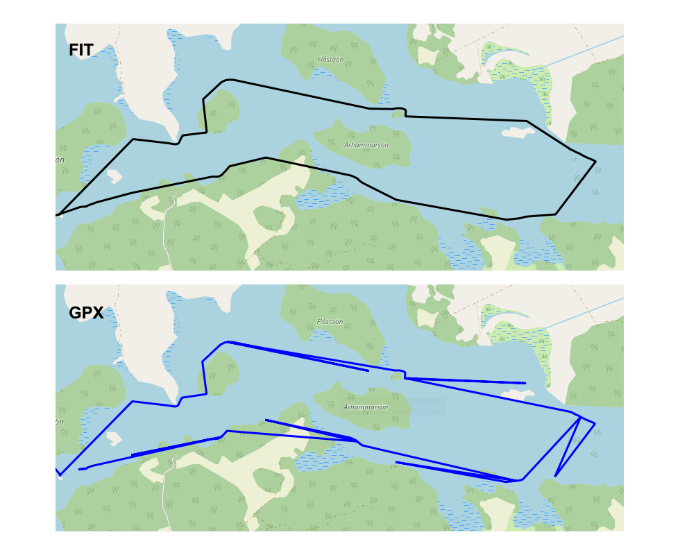
| 27. | Activity recordings created while Expedition Mode is active may result in some data points being swapped or out of sequence in the saved GPX file, but not the saved FIT file. [example] [garmin] | [590] [660] [760] [830] [850] [880] [890] [910] [920] [934] [935] [938] [940] [945] [946] | |
| 28. | TopoActive map updates are not indicated or made available until after a new TopoActive map is downloaded and installed, resulting in most users never knowing updates are available once they have their desired maps loaded. | [440] [470] [480] [530] [590] [660] [760] [830] [850] [880] [890] [910] [920] [934] [935] [938] [940] [945] [946] | |
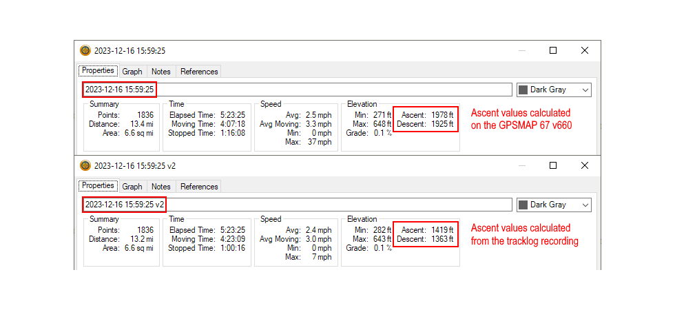
| 29. | Activity recordings may report total ascent/descent values that are substantially exaggerated. [example] [Gr] | [660] [760] [830] [850] [880] | |
| 30. | The 'Total Ascent' data field is updated continuously while Trip Recording is configured for 'During Activity'. [Gr] | (846) | [660] [760] [830] [850] [880] [890] [910] [920] [934] [935] [938] [940] [945] [946] |
| 31. | The Map Manager Map List may be slow to respond after installing update v7.60. [Gr] | [760] [830] [850] [880] | |
| 32. | User is unable to change storage location (Internal or SD Card) when editing Outdoor Maps+ mapsets. (Related: Feature Request 4) | (841) | [530] [590] [660] [760] [830] [850] [880] [890] [910] [920] [934] [935] [938] [940] [945] [946] |
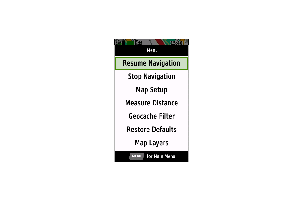
| 33. | The Map Page Menu may display both 'Resume Navigation' and 'Stop Navigation' simultaneously. [example] [Gr] [garmin] | [760] [830] [850] [880] [890] [910] [920] [934] [935] [938] [940] [945] [946] | |
| 34. | Activity recordings (*.FIT) do not include start events when resuming after being paused. [Gr] | [760] [830] [850] | |
| 35. | Starting navigation using 'Roads & Trails' for courses imported from Garmin Explore or Garmin Connect can result in the device navigating a previously selected course. [Gr] [garmin] | [760] [830] [850] [880] [890] [910] [920] [934] [935] [938] [940] [945] [946] | |
| 36. | Some pages may be imroperly duplicated when editing the Page Ribbon Sequence. [garmin] [Garmin have indicated they will not correct this behavior] | [830] [850] [880] [890] [910] [920] [934] [935] [938] [940] [945] [946] | |
| 37. | Map layer selections are not retained after power cycling the device. [Gr] | (944) | [880] [890] [910] [920] [934] [935] [938] [940] [945] [946] |
| 38. | Map Manager mistakenly checks available internal memory storage space for new map downloads when external storage is selected by the user, potentially resulting in a failed or rejected map download. [Gr] | (943) | [880] [890] [910] [920] [934] [935] [938] [940] [945] [946] |
| 39. | Maps with transparent layers may fail to display properly at all zoom levels after installing update v8.90. | [890] [910] [920] [934] [935] [938] [940] [945] [946] | |
| 40. | After scrolling the Map page to a desired location, pressing MENU and selecting 'Download Maps Here', the user can zoom in and out at will, but if the user scrolls the map in any direction and then attempts to zoom in or out, the map will jump to a random location. [Gr] | [890] [910] [920] [934] [935] [938] [940] [945] [946] | |
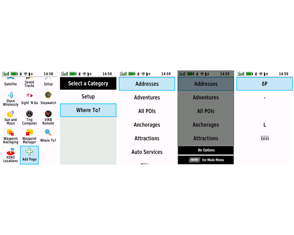
| 41. | From the Main Menu, selecting [Add Page > Where To? > (Menu) > (Quit)] results in a corrupted display. [example] [Gr] | [890] [910] [920] [934] [935] [938] [940] [945] [946] | |
| 42. | The FIND menu may include duplicated POI categories that provide unexpected destination results. [Gr] | [890] [910] [920] [934] | |
| 43. | Find Menu icons are applied incorrectly when [Setup > Menus > Menu Style = Big Grid]. [example] [Gr] | (972) | [880] [890] [910] [920] [934] |
| 44. | The Map Page does not update and is unusable while any map downloads are in progress. | [934] [935] [938] [940] [945] [946] | |
| Crash Reports | |||
| 1. | Opening [Setup > Geocaching > Geocaching Live > Geocache Lists] may result in a device crash. [example] [Gr] | [440] [470] [480] [530] [590] [660] [760] [830] [850] [880] [890] [910] [920] [934] [935] [938] [940] [945] [946] | |
| 2. | Pressing the (Menu) button while viewing an Active Weather Map Tab may result in a device crash. [example] [Gr] | [480] [530] [590] [660] [760] | |
| 3. | Opening a route may result in a device crash. [Gr] | [880] [890] | |
| 4. | Selecting any item and pressing enter after [Find > All POIs > Menu > Spell Search > 'Boat Ramp'] results in a device crash. [Gr] | [890] [910] | |
| Hardware Failures | |||
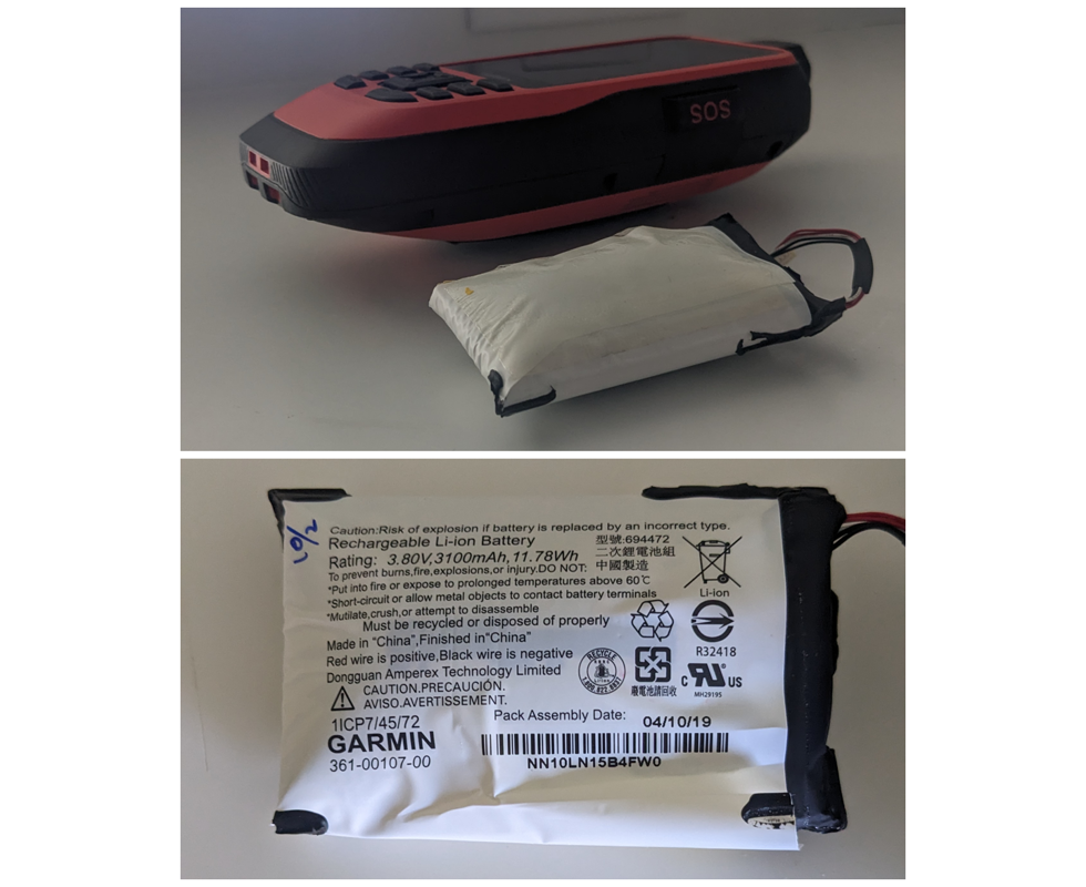
| 1. | The internal Lithium-ion battery pack may experience an off-gassing event that results in over-pressurization of the battery case which can lead to increased temperature, toxic gas emission, and fire. [example] | ||
| Missing Features | |||
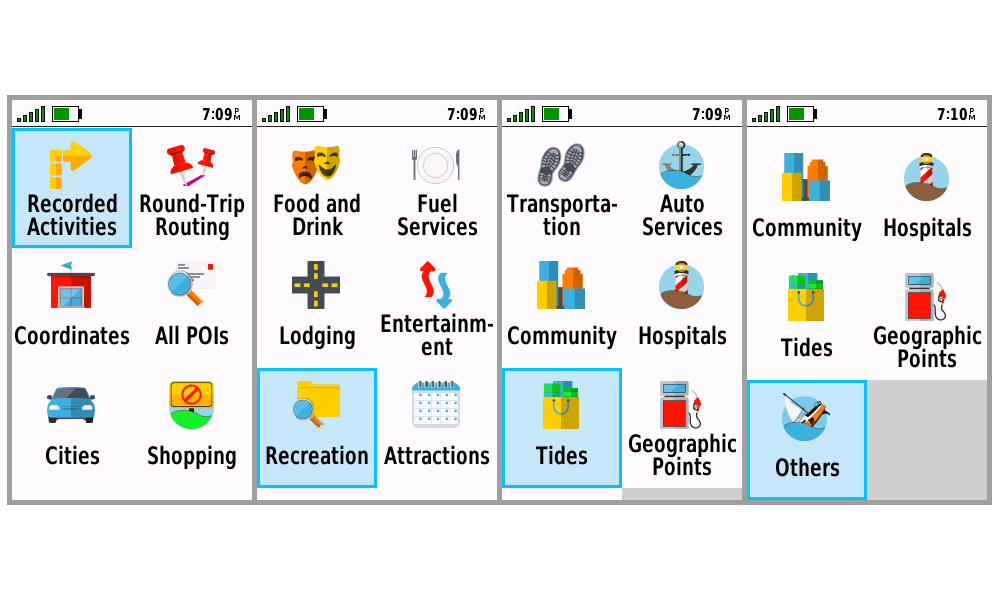
| 1. | TopoActive maps cannot be individually enabled or disabled as was possible with previous models. | (527) | |
| Requested Features | |||
| 1. | Please provide option to display directional chevrons for courses, tracks and routes. | (603) | |
| 2. | Please add an option to automatically lock all keys other than the power button when the screen turns off, and restore button operation when screen is re-enabled after pressing the power button. [Gr] | (609) | |
| 3. | Please add support for third party JNX raster maps. | ||
| 4. | Please allow user to change storage location (Internal and SD Card) when editing Outdoor Maps+ mapsets. (Related: Bug 32) | (111) | |