 |
Interact with a responsive touchscreen and buttons. |
|
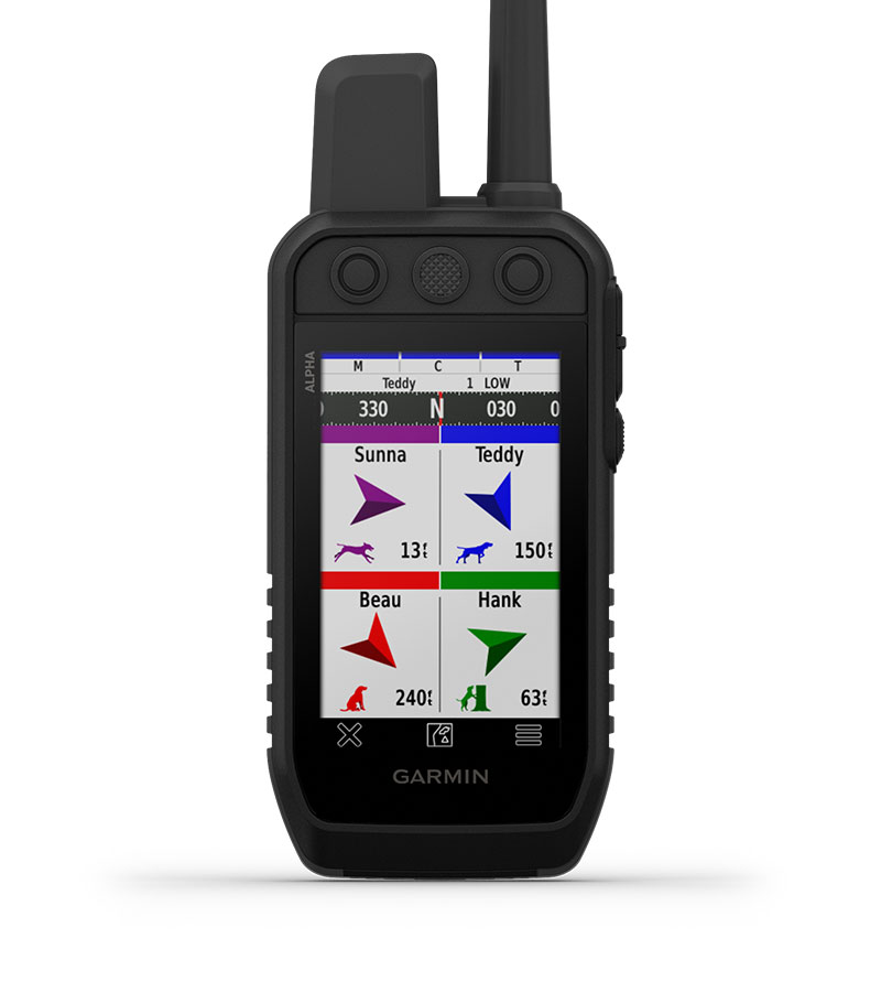
Track and train your pack in the field. | |
 |
The user replaceable battery lasts up to 55 hours. |
 |
Navigate with TopoActive maps and downloadable satellite imagery. | |
 |
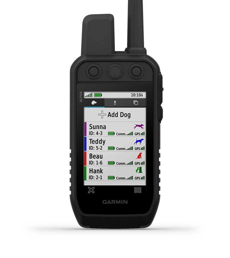
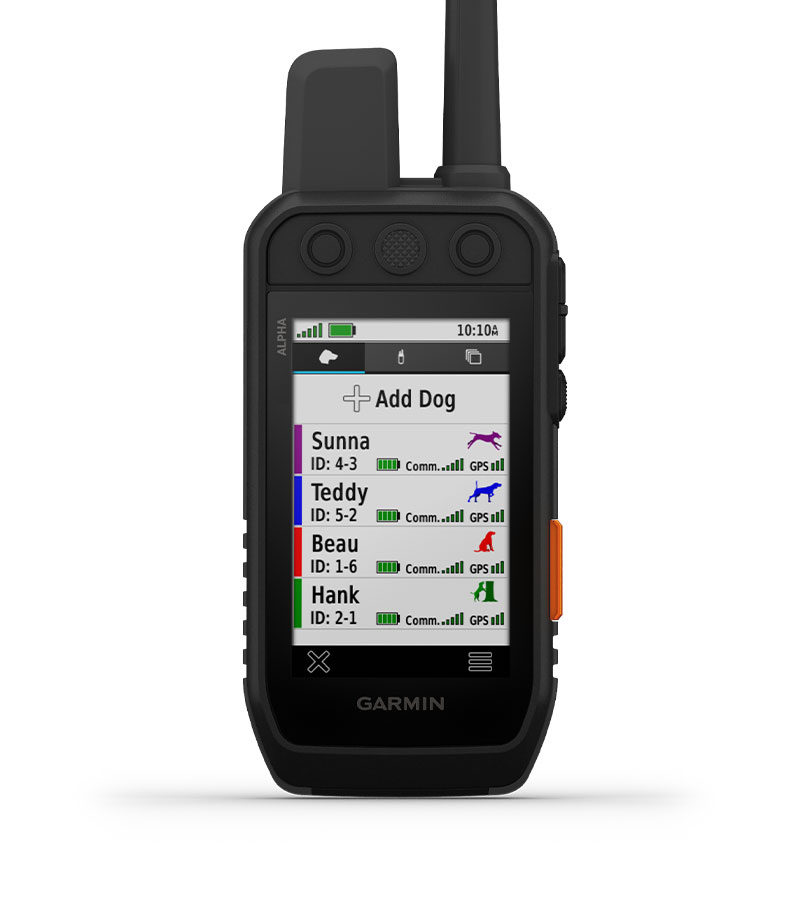
Group Management: Save time at the start of every hunt with groups of dogs and people that match how and whom you hunt with. |
 |
Monitor the Hunt: See when a dog is “treed” or “on point.” | |
 |
Garmin Explore App: Pair with the Garmin Explore smartphone app to review the entire hunt and more. |
 |
Backward Compatible: Easily pair the handheld to select T and TT series collars. | |
 |
Dog List: Store up to 250 dogs, making it easy to switch active collars in the field. |
 |
Multi-GNSS Support: Access multiple global navigation satellite systems for better service in challenging environments. | |
 |
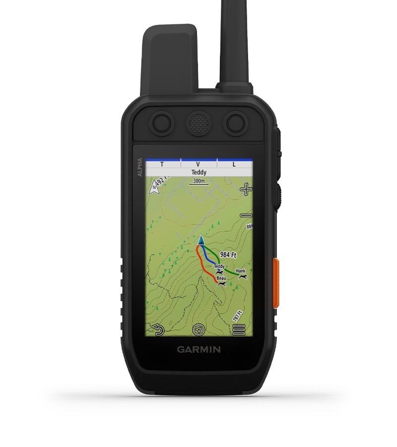
Pro View Compass: This simple, at-a-glance tracking shows which direction and how far away your dogs are. |
 |
Premium Map Features: Subscribe to Outdoor Maps+ and get public land information, enhanced topographic maps, landowner names and more. | |
 |
Altimeter: The barometric altimeter helps you accurately monitor ascent and descent. |
 |
3-Axis Compass: Navigate with the tilt-compensated 3-axis electronic compass - whether you’re moving or not. |
 Vivid Display and Touchscreen |
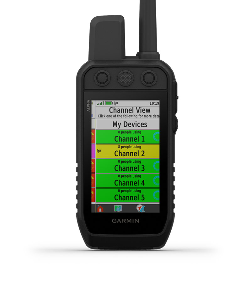 Channel View |
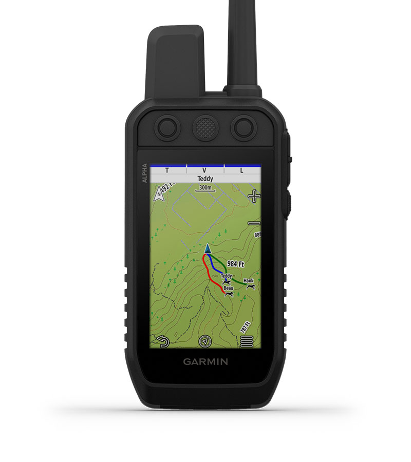 Track Your Pack |
| See your maps and track your dogs on an even brighter 3.5” display with up to a 2.5-second update rate. Easily interact with the device on a responsive touchscreen, even with gloves on, and read the screen in a variety of light conditions. | Monitor the concentration of collars in the area, and easily select less congested channels to avoid interference. | Monitor up to 20 dogs with your compatible dog collars - from up to 9 miles away - on the color touchscreen display. |
 Train Your Pack |
 Hunt Metrics |
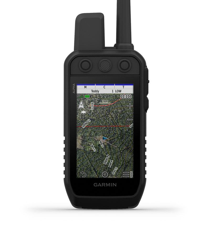 Satellite Imagery |
| Use dedicated buttons for fast training cues and command initiation. Select from 18 levels of momentary and continuous stimulation. Hunters can also issue different levels of audible tone or vibration commands. | See critical hunt metrics, such as distance, speed and time afield, right on the dog info screen. | Download satellite imagery via Wi-Fi technology to your device, and see the terrain features from above to help you navigate or find suitable habitat for your quarry. |
|
|
Interact with a responsive touchscreen and buttons. |
|
Track and train your pack in the field. | |
 |
Communicate via inReach satellite technology. |
|
Navigate with TopoActive maps and downloadable satellite imagery. | |
|
|
Long Lasting Battery: The user replaceable battery lasts up to 55 hours - or 50 hours with inReach technology enabled. |
|
Group Management: Save time at the start of every hunt with groups of dogs and people that match how and whom you hunt with. | |
|
|
Monitor the Hunt: See when a dog is “treed” or “on point.” |
|
Backward Compatible: Easily pair the handheld to select T and TT series collars. | |
|
|
Dog List: Store up to 250 dogs, making it easy to switch active collars in the field. |
 |
See critical hunt metrics, such as distance, speed and time afield, right on the dog info screen. | |
|
|
Garmin Explore App: Pair with the Garmin Explore smartphone app to review the entire hunt and more. |
 |
Garmin Messenger App: Pair with the Garmin Messenger smartphone app for fast, easy satellite messaging. | |
|
|
100% Global Iridium Satellite Network: Messages, SOS alerts and tracking are transferred via the global Iridium satellite network. |
 |
Optional inReach Weather: Get detailed weather reports on the Alpha 300i handheld with the Garmin Explore app. | |
 |
MapShare Trip Sharing Page: Provide friends and family with an easy way to see your progress, view your GPS location and exchange messages during your trip. |
|
Multi-GNSS Support: Access multiple global navigation satellite systems for better service in challenging environments. | |
|
|
Pro View Compass: This simple, at-a-glance tracking shows which direction and how far away your dogs are. |
|
Premium Map Features: Subscribe to Outdoor Maps+ and get public land information, enhanced topographic maps, landowner names and more. | |
|
|
Altimeter: The barometric altimeter helps you accurately monitor ascent and descent. |
|
3-Axis Compass: Navigate with the tilt-compensated 3-axis electronic compass - whether you’re moving or not. |
 Vivid Display and Touchscreen |
 Channel View |
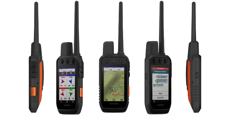
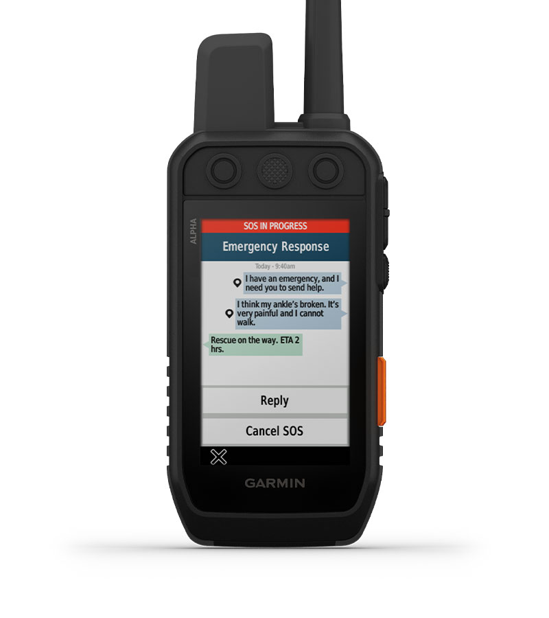 SOS Alerts and Two Way Messaging |
| See your maps and track your dogs on an even brighter 3.5” display with up to a 2.5-second update rate. Easily interact with the device on a responsive touchscreen, even with gloves on, and read the screen in a variety of light conditions. | Monitor the concentration of collars in the area, and easily select less congested channels to avoid interference. | In case of an emergency, use inReach satellite technology to send an interactive SOS message. Keep in touch and exchange text messages with friends and family where cell service doesn’t exist. You can also track your location and share it with those at home or out in the field. |
 Track Your Pack |
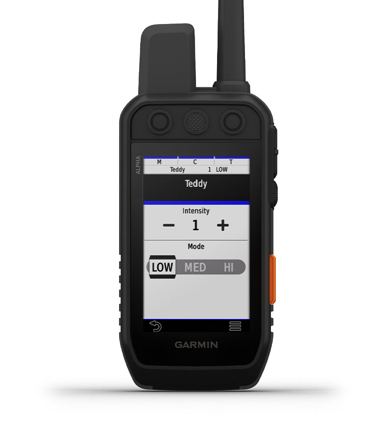 Train Your Pack |
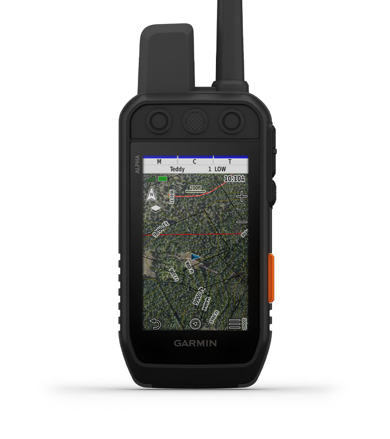 Satellite Imagery |
| Monitor up to 20 dogs with your compatible dog collars - from up to 9 miles away - on the color touchscreen display. | Use dedicated buttons for fast training cues and command initiation. Select from 18 levels of momentary and continuous stimulation. Hunters can also issue different levels of audible tone or vibration commands. | Download satellite imagery via Wi-Fi technology to your device, and see the terrain features from above to help you navigate or find suitable habitat for your quarry. |