 |
This system is designed to help make tracking and training simple, accessible and fast. |
|
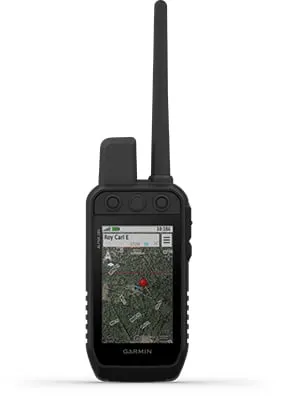
Track and train your pack while they're out in the field. | |
 |
Keep inactive dogs in the system for easier setup and management. |
 |
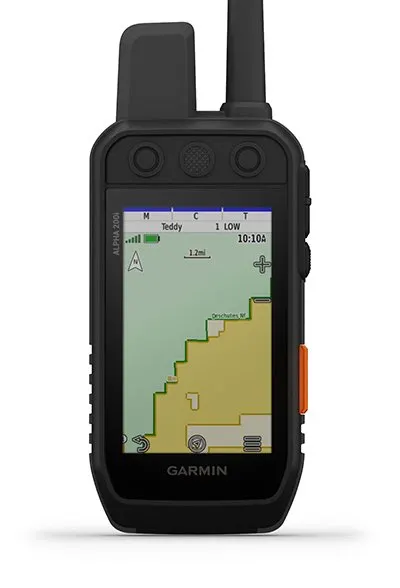
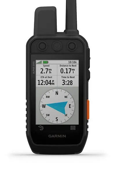
Navigate every hunt with the best in Garmin mapping and sensors. | |
 |
User-replaceable battery lasts up to 20 hours; up to 15 hours with inReach technology enabled. |
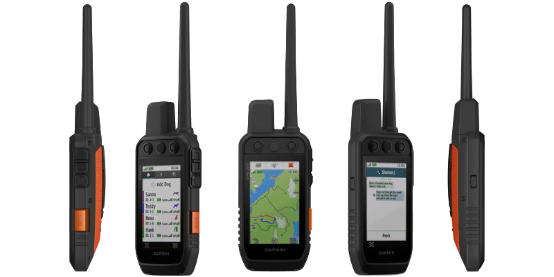
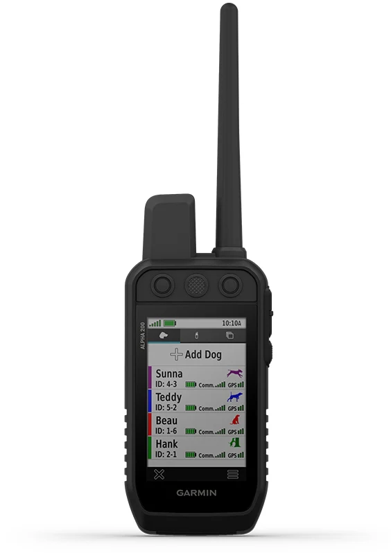
 Track Your Pack |
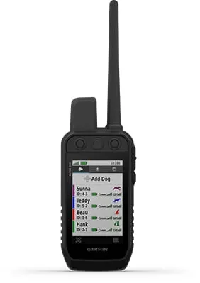
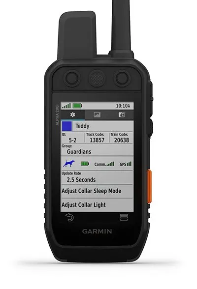
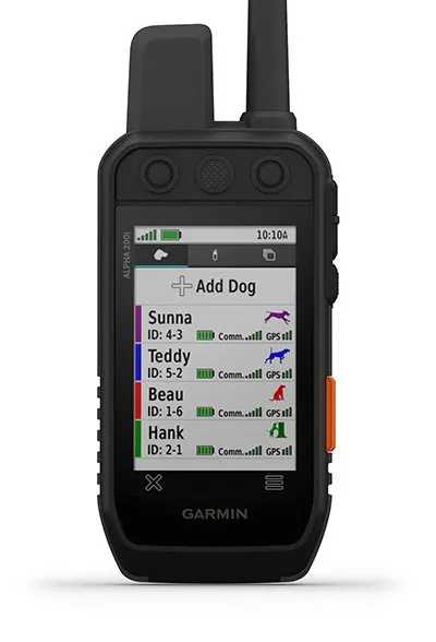
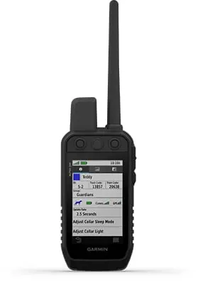 Dog List/Group Management |
 Public Land Boundaries |
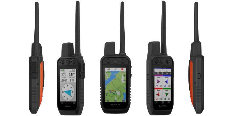
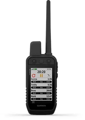
| Monitor up to 20 dogs with your compatible dog collars from up to 9 miles with a 2.5-second update rate. | Keep inactive dogs in your dog list, and manage active groups so you don’t have to add and remove dogs for every hunt. | Optional display of public land boundaries on topographical maps helps you know that you’re venturing where you’re supposed to be. |
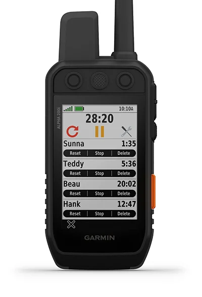
 Hunt Metrics |
 Six-Button Design |
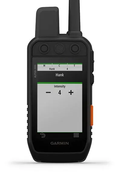
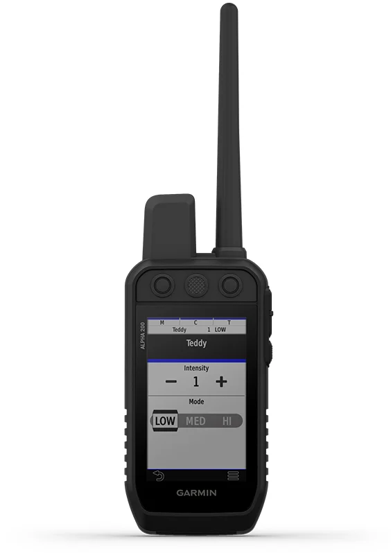
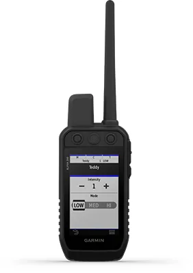 18 Levels of Stimulation |
| See each dog’s daily hunting patterns, distance and speed so you can monitor performance and help prevent overheating. Pair with your compatible Garmin dog collars (sold separately). | Use dedicated buttons for fast training cues and minor adjustments in the field. | Momentary and continuous stimulation options let you customize training for each dog when used with a compatible training enabled collar. |
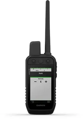 Tone/Vibration |
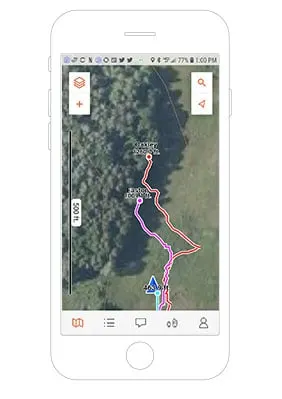 Garmin Explore App |
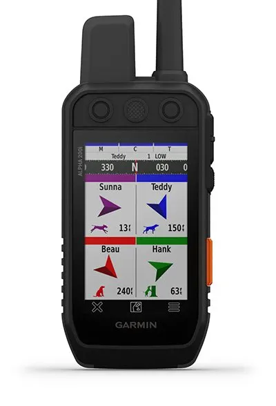
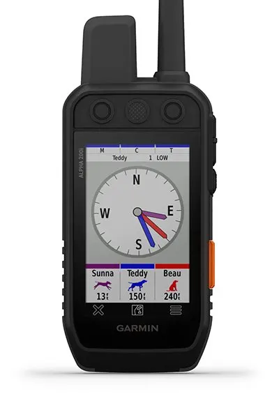
 Pro View Compass |
| Issue different levels of audible tone or vibration commands for quick adjustments to individual dogs when used with a compatible training enabled collar. | Pair with the Garmin Explore smart-device app to see real-time dog tracking information, save collections of dog tracks and replay tracks to see exactly what happened during your hunt. | The pro view compass mode gives you simple, at-a-glance tracking that shows which direction and how far away your dogs are, plus you will see when a dog is “Treed” or “OnPoint.”. |
 Multi-GNSS Support |
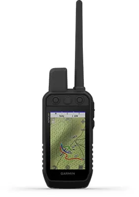
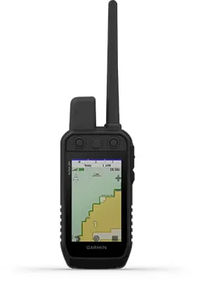
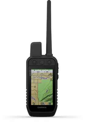
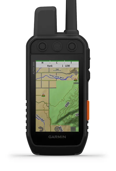
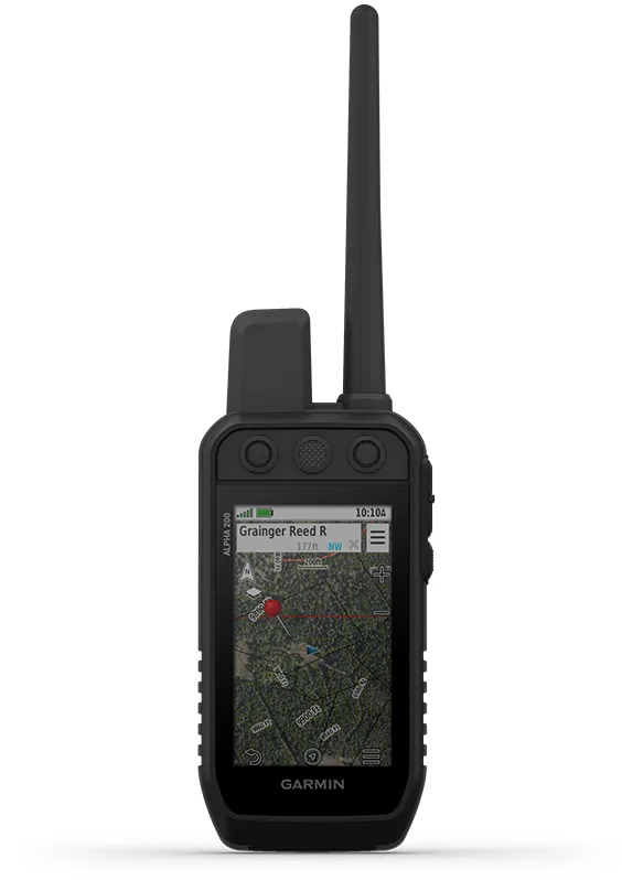
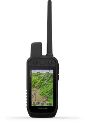 TopoActive Maps |
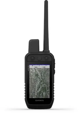 BirdsEye Direct |
| Access multiple global navigation satellite systems (GPS and Galileo) to track your pack with greater accuracy than GPS alone. | Our preloaded TopoActive mapping provides detailed views of terrain contours, topographic elevations, summits, parks, coastlines, rivers, lakes and geographical points. | Download BirdsEye Satellite Imagery directly to the handheld via Wi-Fi connectivity for better-than-real-life views of your route, trailheads, clearings and more. |
 Navigation Sensors |
 See It All |
 Stay on the Move |
| A barometric altimeter helps you accurately monitor ascent and descent and see short-term trends in air pressure, and the built-in tilt-compensated 3-axis electronic compass keeps your bearing - whether you’re moving or not. | The sunlight-readable 3.5” capacitive touchscreen display makes it easy to see and interact with your maps, dog data and more - even while wearing gloves. | The replaceable battery lasts up to 20 hours, giving you plenty of hunt time with your dogs in the field. |
 Additional Mapping |
In-Vehicle Tracking |
|
| The microSD card slot allows you to load more mapping options, such as TOPO U.S. 24K and HuntView maps (each sold separately). | If you’re using a vehicle to follow and retrieve your dogs, the rugged Tread off-road powersport navigator or Garmin DriveTrack 71 car navigator (each sold separately) provide an easy-to-watch “big picture” solution. The moving map display shows dog positions overlaid on TOPO contours or satellite image views - along with navigation cues that help point you to your dog’s current location. | |
|
|
This system is designed to help make tracking and training simple, accessible and fast. |
|
Track and train your pack while they're out in the field. | |
|
|
Keep inactive dogs in the system for easier setup and management. |
 |
inReach technology helps you keep loved ones updated when cellphones can’t (active satellite subscription required). | |
|
|
Navigate every hunt with the best in Garmin mapping and sensors. |
|
User-replaceable battery lasts up to 20 hours; up to 15 hours with inReach technology enabled. |
 Track Your Pack |
 Dog List/Group Management |
 Public Land Boundaries |
| Monitor up to 20 dogs with your compatible dog collars from up to 9 miles with a 2.5-second update rate. | Keep inactive dogs in your dog list, and manage active groups so you don’t have to add and remove dogs for every hunt. Pair with your TT 15 tracking and training collars. | Optional display of public land boundaries on topographical maps helps you know that you’re venturing where you’re supposed to be. |
 Hunt Metrics |
 Six-Button Design |
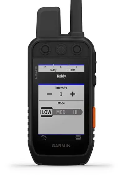 18 Levels of Stimulation |
| See each dog’s daily hunting patterns, distance and speed so you can monitor performance and help prevent overheating. Pair with your compatible Garmin dog collar (sold separately). | Use dedicated buttons for fast training cues and minor adjustments in the field. | Momentary and continuous stimulation options let you customize training for each dog when used with a compatible training enabled collar. |
 Tone/Vibration |
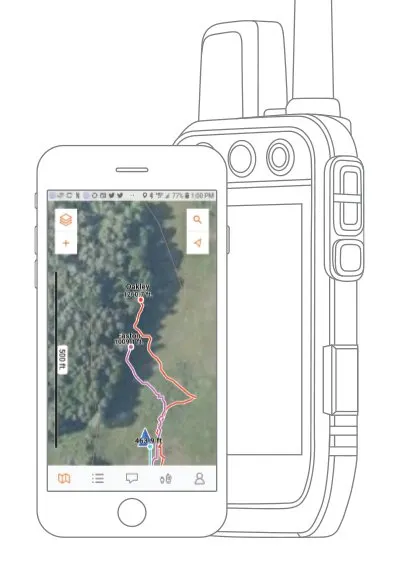 Garmin Explore App |
 Optional inReach Weather |
| Issue different levels of audible tone or vibration commands for quick adjustments to individual dogs when used with a compatible training enabled collar. | Pair with the Garmin Explore app on your compatible smartphone to see real-time dog tracking information, save collections of dog tracks and replay tracks to see exactly what happened during your hunt. | Use inReach connectivity to get detailed weather updates on Alpha 200i or your compatible device paired with the Garmin Explore app. Request weather forecasts for your current location, waypoints or destinations on your route. |
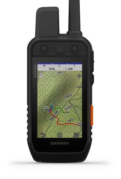
 Pro View Compass |
||
| The pro view compass mode gives you simple, at-a-glance tracking that shows which direction and how far away your dogs are, plus you will see when a dog is “Treed” or “OnPoint.” |
 Multi-GNSS Support |
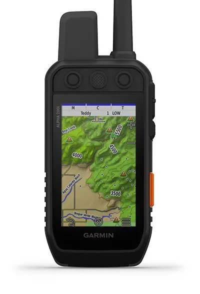 TopoActive Maps |
 BirdsEye Satellite Imagery |
| Access multiple global navigation satellite systems (GPS and Galileo) to track your pack with greater accuracy than GPS alone. | Our preloaded TopoActive mapping provides detailed views of terrain contours, topographic elevations, summits, parks, coastlines, rivers, lakes and geographical points. | Download BirdsEye Satellite Imagery directly to the handheld via Wi-Fi connectivity for better-than-real-life views of your route, trailheads, clearings and more. |
 Navigation Sensors |
 See It All |
 Stay on the Move |
| A barometric altimeter helps you accurately monitor ascent and descent and see short-term trends in air pressure, and the built-in tilt-compensated 3-axis electronic compass keeps your bearing - whether you’re moving or not. | The sunlight-readable 3.5” capacitive touchscreen display makes it easy to see and interact with your maps, dog data and more - even while wearing gloves. | Replaceable battery lasts up to 20 hours, or up to 15 hours with inReach technology enabled. |
 Additional Mapping |
In-Vehicle Tracking |
|
| The microSD card slot allows you to load more mapping options, such as TOPO U.S. 24K and HuntView Plus maps (each sold separately). | If you’re using a vehicle to follow and retrieve your dogs, the rugged Tread off-road powersport navigator, the Garmin DriveTrack 71 car navigator or a Montana 700 Series handheld (each sold separately) provide an easy-to-watch “big picture” solution. The moving map display shows dog positions overlaid on TOPO contours or satellite image views - along with navigation cues that help point you to your dog’s current location. | |
 Two-Way Messaging |
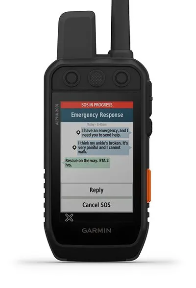 Interactive SOS Alerts |
 Location Sharing |
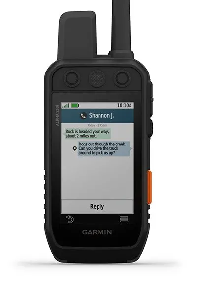
| Exchange text messages with loved ones, post to social media, or communicate inReach to inReach in the field (active satellite subscription required). | In case of emergency, trigger an interactive SOS message to the Garmin IERCC, a 24/7 staffed professional emergency response coordination center (active satellite subscription required). | Track your location, and share it with those at home or out in the field so they can see your progress or ping your device for your GPS location and more (active satellite subscription required). |
 100% Global Iridium Network |
||
| Instead of relying on cellphone coverage, now your messages, SOS alerts and tracking are transferred via the global Iridium satellite network (active satellite subscription required). |

|
|
Track And Train Your Pack In The Field. |
 |
Channel View Helps Avoid Frequency Congestion. | |
 |
Follow The Action On A 3.5-Inch Color Touchscreen. |
|
The User-Replaceable Battery Lasts Up To 55 Hours. | |
 |
User-Friendly 6-Button Design For Fast Cues And Commands. |
 |
Navigate With Topoactive Maps And Downloadable Satellite Imagery. |
 Track Your Pack |
 Train Your Pack |
 See It All |
| Monitor up to 20 dogs with your compatible dog collars from up to 9 miles away on the handheld’s color touchscreen display. | Use dedicated buttons for fast training cues and command initiation. Select from 18 levels of momentary and continuous stimulation. Hunters can also issue different levels of audible tone or vibration commands. | The sunlight-readable 3.5-inch capacitive touchscreen display makes it easy to see and interact with your maps, dog data and more, even while wearing gloves. |
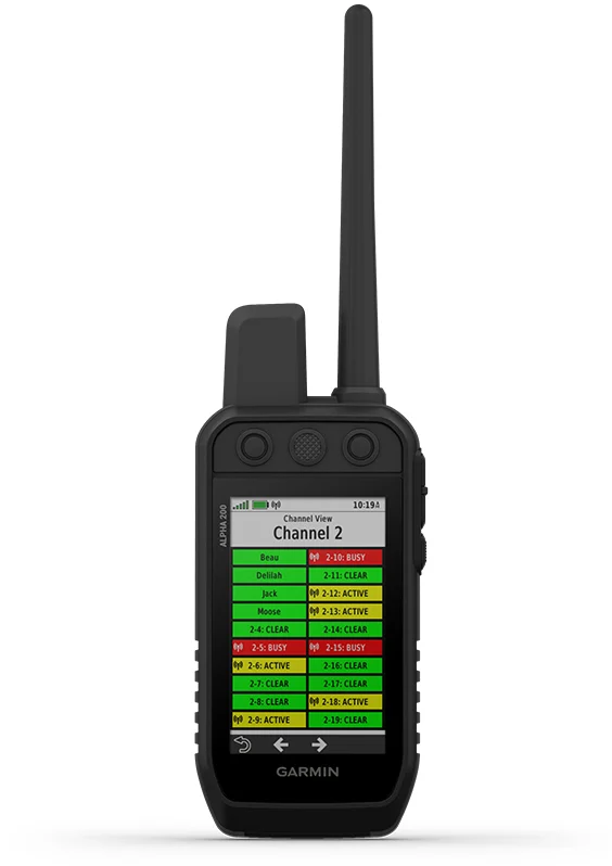 Channel View Feature |
 Hunt Metrics |
 Satellite Imagery |
| Monitor the concentration of collars in the area, and easily select less congested channels to avoid interference. | See critical hunt metrics, such as distance, speed and time afield, right on the dog info screen. | Download satellite imagery via Wi-Fi technology to your device, and see the terrain features from above to help you navigate or find suitable habitat for your quarry. |
 |
Group Management: Save time at the start of every hunt with groups of dogs and people that match how and whom you hunt with. |
 |
Monitor The Hunt: See when a dog is “treed” or “on point.” | |
 |
Alpha App: Pair with the Alpha smartphone app to see and save real-time dog tracking data. |
 |
Backward Compatible: Easily pair the handheld to select T and TT series collars. | |
|
|
Dog List: Store up to 250 dogs, making it easy to switch active collars in the field. |
 |
Multi-GNSS Support: Access multiple global navigation satellite systems for better service in challenging environments. | |
 |
Pro View Compass: This simple, at-a-glance tracking shows which direction and how far away your dogs are. |
|
TopoActive Maps: Get detailed views of terrain contours, topographic elevations, summits, parks and more. | |
 |
Premium Map Features: Subscribe to Outdoor Maps+, and get public land information, landowner names and more. |
 |
Altimeter: The barometric altimeter helps you accurately monitor ascent and descent. | |
 |
3-Axis Compass: Navigate with the tilt-compensated 3-axis electronic compass, whether you’re moving or not. |