- If your Garmin GPSMAP 66 is exhibiting bad behavior you do not see listed here, please post a new thread about your experience and send a detailed error report to Garmin, as outlined below.
- If you do see your issue listed here, please send your detailed error report to Garmin! They need to hear from all users.
- Please handle all feature requests similarly: Post a new thread if not already listed, and send a copy to Garmin.
- If you see your request is already listed, copy and paste it in an email to Garmin! The more frequently they see the same request, the more likely they are to include it in a future update.
Error Reporting
- Please report all software bugs, glitches, crash reports, and feature requests in the GPSMAP 66 discussion forum.
- Try to include as much detail as possible when describing each issue you are experiencing, including profile settings, maps enabled, keystrokes, etc.
-
Send a copy of your post to
product.support@Garmin.com and include:
- a copy of the System.xml file located in the [GPSMAP]\Garmin\ directory.
- a copy of the GarminDevice.xml file located in the [GPSMAP]\Garmin\ directory.
- any *.fit files associated with the crash or bug from the [GPSMAP]\Garmin\Activity\ or [microSD]\Garmin\Activity\ directories.
- any *.gpx files associated with the crash or bug from the [GPSMAP]\Garmin\GPX\ or [microSD]\Garmin\GPX\ directories.
Status
- RED: Issue/Feature Request has been reported to Garmin, and is pending response.
- ORANGE: Garmin has acknowledged a Reported Issue/Feature Request and may be working on a solution.
- GREEN: Issue has been resolved and no longer exists. Requested Feature has been implemented.
Categories
- Bugs (41/19/91): Software issues that result in a system failure or adversely affect intended functionality.
- Crash Reports (03/00/13): Bugs resulting in unintentional hanging, freezing, resetting or powering down.
- Hardware Failures (04/00/00): Physical issues and/or failures that limit or inhibit intended function.
- Missing Features (06/02/03): Feature is available on a similar Garmin product.
- Requested Features (36/03/02): Request for functionality not present with current firmware version.
Bugs
| 1. | When logging a geocache as 'Found' on a GPSMAP 66 with [Setup] > [Geocaching] > [Geocaching Live] > [Auto Upload Logs] = [On], the uploaded log reads 'Submitted via Garmin Oregon 7xx'. [Gr] | [210] [250] [280] | |
| 2. | After disconnecting external power from a GPSMAP 66 that is powered up and running, with [Setup] > [Expedition Mode] = [Prompted], the user is given the option to 'Turn Off' or 'Stay On', and selecting 'Turn Off' results in a complete shut down opposed to entering 'Expedition Mode', as expected. | [210] [250] [280] [290] [300] [310] | |
| 3. | Geocaching description does not retain it's place when switching between pages, always returning to the top of page. | (747) | [210] [250] [280] [290] [300] [310] [320] [330] [340] [410] [420] [470] |
| 4. | Frequently, the Bluetooth Setup Status will display 'Connecting...' indefinitely, requiring the user to either A. Open the Garmin Connect application on the paired Android Device to complete the connection, or B. Delete both devices from each other and repeat the pairing process as new. | (865) | [210] [250] [280] [290] [300] [310] [320] [330] [340] [410] |
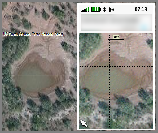
| 5. | BirdsEye
Direct Map Behavior Issue (Requires BirdsEye Satellite Imagery loaded on
GPSr):
|
(743) | [210] [250] [280] [290] [300] [310] [320] [330] [340] [410] [420] [470] [480] [490] [500] [600] [700] [710] [720] [730] [740] [760] [960] [990] [1000] [1010] [1020] [1030] [1050] [1070] |
| 6. | The 'Go' button on the Geocaching > Chirp > Information page is displayed almost entirely off the bottom of the screen and is unusable. [example] (See Bug 32 for temporary work-around) | [210] [250] [280] [290] [300] [310] [320] [330] [340] [410] [420] [470] | |
| 7. | The Chirp Icon in the Active Geocache menu does not change color to indicate the presence of Chirp Data, as with previous models. | (728) | [210] [250] |
| 8. | The Geocache Dashboard does not add an ANT logo near the top left of the Compass to indicate chirp data is present, as with previous models. | (728) | [210] [250] |
| 9. | Pre-made/Custom Geocaching Filters can not be accessed or used from Geocaching page. | (731) | [210] [250] |
| 10. | After initiating a Master Reset during power up and selecting 'Cancel', the GPSMAP 66 still proceeds with and completes a Master Reset. | [210] [250] | |
| 11. | After enabling 'Lock Keys' in Status page, the previously active page the status menu was entered from becomes frozen (if page ribbon was displayed, it is frozen on display, if compass page was active, compass remains frozen). | (740) | [210] [250] [280] [290] [300] |
| 12. | Custom
Dashboard navigation issue:
|
(738) | [210] [250] |
| 13. | Large Temperature data field displays small text (identical to what is found in small Temperature data field) and is not centered properly in the large data field. [example] | [210] [250] | |
| 14. | In Active Route page: User can scroll up/down one item at a time and select with 'Enter' button, but once detailed turn view is displayed, they can not scroll to the previous or next detailed turn like with previous GPSr (Oregon 6x0, 7x0, Montana, etc.). D-PAD buttons do nothing, +/- buttons do nothing. Should be able to scroll through detailed turn info without having to exit to menu each time. | (737) | [210] [250] [280] [290] [300] [310] |
| 15. | In the Geocache List view, after pressing (Menu) and selecting [Filter], changing filter settings, then pressing (Quit) to return to the Geocache List view, the list of geocaches is not updated to reflect the filter changes made. The user must first exit and return to the Geocache List view before the geocache list is updated to reflect the new filter settings. | [210] [250] | |
| 16. | After selecting an Adventure and starting navigation, then opening the Active Route page, waypoints are listed by incorrect distance, displayed in negative feet [example]. | (735) | [210] [250] |
| 17. | Map Selection: GPSMAP 66 is unable to remember map selection preferences over a power cycle. Regardless of which maps are enabled/disabled, each power cycle results in all maps (other than BirdsEye) being enabled. | [210] [250] | |
| 18. | When powered off while connected to an external (USB) power source, the GPSMAP 66 continues to display the animated 'Battery Charging' screen indefinitely, even after the battery has been fully charged. The non animated 'Fully Charged' screen never appears as it does with other Garmin GPSr. | [210] [250] | |
| 19. | The GPSMAP 66 does not retain Geocache Filter settings after a power cycle. | [210] [250] | |
| 20. | GGZ Files are not always properly indexed/displayed - GGZ files that function correctly on other Garmin GPSr (Oregon 6x0/7x0, Montana, etc.) models are not displayed on the Map page or in the Geocache List. | (733) | [210] [250] |
| 21. | When editing Geocache 'Next Stage' coordinates, the Up/Down arrows do not adjust selected number higher/lower as expected. | (732) | [210] [250] |
| 22. | After locating a blank chirp and selecting 'No' when asked if programming is desired, the chirp menu is exited and the user is left with no ability to re-enter the chirp menu to access other chirp functions until after a power cycle has been performed. | (727) | [210] [250] [280] [290] [300] [310] [320] [330] [340] [410] [420] [470] [480] [490] [500] [600] [700] [710] [720] [730] [740] [760] [960] [990] [1000] [1010] [1020] [1030] [1050] [1070] |
| 23. | Sensors do not show up in Status Page when none are enabled, preventing quick access by user. [Garmin: "This is intended behavior to prevent cluttering the Status page"] | [210] | |
| 24. | Intermittently, the high temp for the left-most day in the weather forecast page and the high temp for the current day are not displayed. | [210] [250] [280] | |
| 25. | Selecting [Where To?] > [Recent Finds] can result in several Ghost Waypoints being displayed, each with coordinates near null island. | (730) | [210] [250] |
| 26. | "Cannot authenticate maps. Contact the map content seller for help." may be displayed at power up after installing an OSM map product. (Garmin: "UTF-8/Unicode maps must be signed, use Latin version when available") | (750) | [210] |
| 27. | Scale Numbers appear to be improperly aligned in Marine Tide Table Charts. [example] | (748) | [210] [250] [280] [290] [300] [310] [320] [330] [340] [410] [420] [470] |
| 28. | The Weather page will intermittently display only three hours of forecast information, leaving the fourth hour empty. | [210] [250] [280] [290] [300] [310] [320] [330] [340] [410] [420] [470] [480] [490] [500] [600] [700] [710] [720] [730] [740] [760] [960] [990] | |
| 29. | BirdsEye Satellite Imagery maps are not scaled the same on the GPSMAP 66 as when displayed in BaseCamp. Which is correct? Which is distorted? [example 1] [example 2] | [210] [250] [280] [290] [300] [310] [320] [330] [340] [410] [420] [470] [480] [490] [500] [600] [700] [710] [720] [730] [740] [760] [960] [990] [1000] [1010] [1020] [1030] [1050] [1070] | |
| 30. | Intermittently, waypoint distances listed in the Waypoint Manager page will suddenly change from actual distance to the approximate distance to null island. [example] | [210] | |
| 31. | Currently, there are no visual indications as to which maps are enabled or disabled in the [Map > Setup > Custom Maps] list. | [210] [250] [280] [290] [300] [310] [320] [330] [340] [410] [420] [470] | |
| 32. | With chirp data loaded, selecting [chirp] from the 'Active Geocache Tab' in the Geocaching page displays the chirp information page partially pushed off the bottom of the screen by the [chirp Searching] = [on/off] function, obfuscating and rendering useless the [Go] button which can not be highlighted anyway (See Bug 6). Interestingly enough, cycling the (Power) button here incorrectly initiates the mostly hidden [Go] function. [example] | (937) | [210] [250] [280] [290] [300] [310] [320] [330] [340] [410] [420] [430] |
| 33. | After entering the PIN to program a chirp, the user is returned to the [Setup] > [Geocaching] menu with no options highlighted, and each press of the (up)/(down) buttons results in one of the chirp editing menu functions being drawn over the top of the existing menu. [example] | [250] [280] [290] [300] [310] [320] [330] [340] [410] [420] [470] [480] [490] [500] [600] [700] [710] [720] [730] [740] [760] [960] | |
| 34. | The Geocache
Dashboard always shows the ANT logo near the Compass
with [Setup] > [Geocaching] > [chirp Searching] = [On] and:
|
(773) | [250] [280] [290] [300] |
| 35. | After completing a [Setup] > [Reset] > [Reset All Settings], the user may be prompted with a 'Select Desired Language' menu some time later, after having already begun using the GPSr. | (778) | [250] [280] |
| 36. | When sending geocaches to compatible Garmin GPSr using the Share Wirelessly feature, the geocache name and coordinates are transferred while the geocache description, hints and logs are not, producing a useless geocache file on the receiving GPSr. [example] | (764) | [250] [280] [290] [300] [310] [320] [330] [340] [410] [420] [470] [480] [490] [500] [600] [700] [710] [720] [730] [740] [760] [960] [990] [1000] [1010] [1020] [1030] [1050] [1070] |
| 37. | The Geocache List Search function intermittently fails to locate geocaches loaded to the device. [example] [Related: Bug 43) | (787) | [250] [280] |
| 38. | Using any of the 11 available Geocache Type filters results in all geocaches of types 'Geocache', 'Project APE Cache', 'Locationless (Reverse) Cache', 'Geocache Course (Maze Exhibit)', 'Giga-Event', 'Other Cache', and 'Lab-Cache' also being disabled. Restoring any Geocache Type filter only returns geocaches of like type to the geocache map and geocache list views, while the previously listed geocache types remain permanently hidden, leaving the user with no option or method to restore them (other than an undesirable hard-reset). [Firmware 2.50 added a 'Show All' geocache filter, however the unwanted filtering issue remains unresolved.] | [210] [250] [280] [290] [300] [310] [320] [330] [340] [410] [420] [470] [480] [490] [500] [600] [700] [710] [720] [730] [740] [760] [960] [990] [1000] [1010] [1020] [1030] [1050] [1070] | |
| 39. | POIs with proximity alerts sent to the GPSMAP 66 using Garmin POI Loader 2.7.3 may fail to alert as expected. [groundspeak] | (770) | [250] [280] [290] [300] [310] [320] [330] [340] [410] [420] [470] [480] [490] [500] [600] [700] |
| 40. | After choosing a geocache, selecting 'Go', and then opening the Geocaching page, the GPSMAP 66 may return to the 'Geocache List' again, requiring the user to repeat the geocache selection and begin navigation sequence before finally displaying the 'Active Geocache' page as expected once navigation to the geocache has begun. [groundspeak] | [250] [280] | |
| 41. | With [Setup] > [Position Format] = [hddd°mm.mmm'] selected, coordinates are actually displayed as hddd°mm.mmmm'. (related to Feature Request 11) | (777) | [250] [280] [290] [300] [310] [320] [330] [340] [410] [420] [470] |
| 42. | Geocache indexing behavior can produce incomplete results when viewed at higher zoom levels. Comparable Garmin GPSr models do not produce the same results with identical files loaded. [example] | (786) | [250] [280] |
| 43. | Geocaches loaded via GCLive may fail to appear in either the Geocache List or Geocache Map, but can be found in the 'Recent Finds' menu. [groundspeak] [Related: Bug 37] | (787) | [250] [280] |
| 44. | Attempting to connect with a HRM-Dual always returns the message "Multiple Sensors Found', and a connection is never made. [Gr] | (687) | [250] [280] [290] [300] [310] |
| 45. | [Setup] > [Units] configuration is not Profile dependent, unlike previous and/or similar Garmin GPSr. [groundspeak] [Garmin: "This is an intentional change intended to simplify device operation"] [Gr: "Garmin finally acquiesced in May 2022"] | [250] [280] [290] [300] [310] [320] [330] [340] [410] [420] [470] [480] [490] [500] [600] [700] [710] [720] [730] [740] [760] [960] [990] [1000] | |
| 46. | [Waypoint Manager] > (Menu) > [Select Symbol] > {any symbol} > (Menu) > [Delete All] option is absent from firmware 2.90. [Gr] [Garmin: "This change was made intentionally to prevent Crash 4"] [GPSrChive: "This feature is present and functional on similar models, please resolve without removing capability"] | (808) | [290] [300] [310] [320] [330] [340] [410] [420] [470] [480] [490] [500] [600] [700] [710] [720] [730] [740] [760] [960] [990] [1000] [1010] [1020] [1030] [1050] [1070] |
| 47. | [Waypoint Manager] > (Menu) > [Sort] > [Alphabetical] > (Menu) > [Select Symbol] > {any symbol} results in an endless list of Ghost Waypoints at bottom of waypoint list. Scrolling from one Ghost Waypoint to the next results in brief display of a random waypoint. [example] | (809) | [280] [290] [300] |
| 48. |
[Photo Viewer] > (Menu) > [Sort Photos] results in a menu
titled "Select A Location To Display Photos Near" with the three options below:
[Photo Viewer] > (Menu) > [Sort Photos] menu should be titled "Select A Photo Sorting Option" (or similar) while retaining the same three options. |
(810) | [280] [290] [300] |
| 49. | [Photo Viewer] > (Menu) > [Sort Photos] > [On A Specific Date] always shows all photos loaded, regardless of date chosen. [Garmin: "The photo viewer will scroll you to photos that were taken on the specified date - It will not filter or hide photos that are from other dates."] | (812) | [280] [290] [300] |
| 50. | Pressing (Menu) > (Menu) > {any function} > (Quit) from any active page returns the user to the page immediately preceding the 'Main Menu' icon in the Page Ribbon sequence, instead of returning the user to the page that was active when the '(Menu) > (Menu)' function was initiated. This only occurs if the 'Main Menu' icon is included in the Page Ribbon sequence. Removing the 'Main Menu' icon from the Page Ribbon sequence restores proper function. | (822) | [210] [250] [280] [290] [300] [310] [320] [330] [340] [410] [420] [470] |
| 51. | Elevation data saved in track logs recorded with Expedition Mode enabled may be erratic, inconsistent and/or unreliable. [Gr] | (816) | [250] [280] [290] [300] [310] |
| 52. | Routing method does not change when switching between Profiles where the new profile routing method is set to 'Prompted' (should be Profile Dependent). [Gr] [Gr] | [250] [280] [290] [300] [310] [320] [330] [340] [410] [420] [470] [480] [490] [500] [600] [700] [710] [720] [730] [740] [760] [960] [990] [1000] [1010] [1020] [1030] [1050] [1070] | |
| 53. | The boot process may intermittently stall at the "Loading Waypoints, Tracks, and Routes..." progress bar for several hours. [Gr] [potential solution] | [280] [290] [300] | |
| 54. | GPSMAP 66 will not power on after disconnecting from a USB 'Mass Storage' connection with [Setup > Altimeter > Pressure Trending = Save Always] until a USB connection is restored. [Gr] | (821) | [280] [290] [300] [310] |
| 55. | GC Live function fails to download any additional child waypoints (Parking, Multi-cache stages, etc.) when available, effectively rendering the GC Live 'feature' useless for a large percentage of available geocaches. [groundspeak] | (825) | [210] [250] [280] [290] [300] [310] [320] [330] [340] [410] [420] [470] |
| 56. | Cycling the power button to 'Resume' from Expedition Mode frequently results in an (indicated) total satellite connection failure. All GPS signal strength bars will be empty, the Map page will show a blinking "?" over the position icon (which is still located at the last place the GPSr had a signal), and the Satellite page will show zero satellites available. [Gr] [Gr] | [300] [310] [320] [330] [340] [410] | |
| 57. | Custom Maps (KMZ) placed in the [micro-SD]\Garmin\CustomMaps\ directory are not indexed or displayed, contradictory to all previous generations of Garmin GPSr supporting Custom Maps. | [210] [250] [280] [290] [300] [310] | |
| 58. | While in the Satellite page, pressing (Find) and selecting any waypoint, geocache, etc. results in the [Use] button being displayed (which is use-less) instead of the [Go] button, WHEN the Satellite page is entered from the Page Ribbon. [groundspeak] [example] | [210] [250] [280] [290] [300] [310] [320] [330] | |
| 59. | Garmin Adventure icons are not always displayed correctly on the GPSMAP 66 (same Garmin Adventure icon displays properly on similar GPSr). [example] | (840) | [210] [250] [280] [290] [300] [310] [320] [330] [340] [410] [420] [470] |
| 60. | Map rendering speed is noticeably slower (can be very slow) when a dashboard is enabled, most notably the Geocache and Satellite dashboards. [Gr] | (850) | [210] [250] [280] [290] [300] [310] [320] [330] [340] [410] [420] [470] [480] [490] [500] [600] [700] [710] [720] [730] [740] [760] [960] [990] [1000] [1010] [1020] [1030] [1050] [1070] |
| 61. | Some users report the ° symbol is missing in [Setup] > [Position Format] > [hdddmm.mmm'], which should read hddd°mm.mmm'. This issue affects coordinates displayed throughout the device and is persistent even after changing language settings. [example] [Gr] [FIX] | [All] | |
| 62. |
GPSMAP 66 - Main Menu Corruption [example]
|
(855) | [310] [330] |
| 63. | When [Setup] > [Map] > [Orientation] = [Track Up], the Map page frequently fails to display map data near the bottom of the screen. [examples] [Gr] | (861) | [310] |
| 64. | Speed Limit data field may not function as expected. [examples] | (860) | [310] |
| 65. | Automotive Turn data field may not function as expected. [examples] | (860) | [310] |
| 66. |
While viewing both 'Altitude' and 'GPS Altitude'
Trip Computer
data fields with [Setup] > [Altimeter] > [Auto Calibration] =
[Continuous] and [Setup] > [Recording] > [Auto Start] = [Off] selected: [Gr]
|
(864) | [210] [250] [280] [290] [300] [310] [320] [330] [340] [410] [420] [470] |
| 67. | When navigating to 'Next Stage' coordinates for a geocache that does not exist in any GPX or GGZ file, the Geocaching page no longer displays the description for the parent geocache, which often includes critical information required to complete the search. [garmin de] | (863) | [310] [320] [330] [340] [410] [420] [470] [480] [490] [500] [600] [700] |
| 68. | Tracklogs created with Expedition Mode active are frequently reported with tens of thousands of additional miles beyond actual distance traveled in both the 'Activity Distance' data field and saved GPX file '<gpxtrkx:Distance>' tag. [example] [forum] | [210] [250] [280] [290] [300] [310] [320] [330] [340] [410] | |
| 69. | Map page menu options 'Show Dashboard', 'Hide Dashboard' and 'Geocache Filter' are always displayed in English, regardless of user selected language. [example] [Gr] | (875) | [330] [340] [410] [420] [470] |
| 70. |
Saved Track Elevation Plot Cursor Control Issue - The behavior described below in step 8 should (is expected to) occur following
steps 6 and 7, not the behavior described in step 9: [Gr]
|
(881) | [300] [310] [320] [330] [340] [410] [420] [470] |
| 71. | EPO.BIN file does not always update with Wi-Fi enabled or when performing a 'sync' operation with Garmin Connect. [Gr] | [340] [410] [420] [470] | |
| 72. | Multiple tracklog statistics do not properly reset after clearing a tracklog in the Recording Controls page, including Minimum and Maximum Elevation, Total Ascent and Descent, and Calories. [Gr] | (888) | [340] [410] |
| 73. | Selecting (Find) > [Cities] > (Menu) > [Spell Search] can provide an extremely sluggish response to user input and displayed results, and may result in [crash 8]. [example 1] [example 2] [Gr] | (887) | [310] [330] [340] [410] [420] [470] [480] [490] [500] [600] [700] [710] [720] [730] [740] [760] [960] [990] [1000] [1010] [1020] [1030] [1050] [1070] |
| 74. | Selecting [Setup] > [Sensors] > [Fitness] > [Bike Spd/Cad Sensor] > [Status] > [Off] has no affect on sensor status, which always remains in 'Searching' mode. [example] | (884) | [340] [410] |
| 75. | Saved waypoint symbols do not always agree between map display and waypoint manager display. [example] | (885) | [340] [410] [420] |
| 76. | After opening the Status page (cycle power button) and selecting 'Weather', 'Wi-Fi', 'Bluetooth', 'Sensors' or 'Notifications', and then pressing (Quit), the user is returned to the Status page, as expected. However, after selecting 'Activity Recording' in the Status page and then pressing (Quit), the user is not returned to the Status page, which is unexpected. [Gr] | (882) | [340] [410] [420] [470] |
| 77. | Adventures may randomly lose data and/or disappear from the device, and the user may find Adventure data files moved and/or deleted between microSD card and internal memory. | [340] [410] [420] [470] [480] [490] [500] [600] [700] [710] [720] [730] [740] [760] [960] [990] [1000] [1010] [1020] [1030] [1050] [1070] | |
| 78. |
Geocaching quick filter selections are not always properly retained.
[similar to
Oregon 6x0 Bug 11,
Oregon 7x0 Bug 44, and
eTrex Touch Bug 8]
|
[250] [280] [290] [300] [310] [320] [330] [340] [410] [420] [470] | |
| 79. | Immediately after opening the Waypoint Manager page, while the waypoint list is populating, the user can D-PAD Up to jump to the end of the waypoint list and D-PAD Down to get back to the beginning of the waypoint list, but once the waypoint list is fully populated, this function is no longer available. [Gr] | [410] [420] [470] | |
| 80. | After scrolling through pages of waypoints in the Waypoint Manager page list, then selecting and deleting a waypoint, the user is returned to the beginning of the waypoint list instead of being returned to the place in the list where they left off. [Gr] | [410] [420] [470] [480] [490] [500] [600] [700] [710] [720] [730] [740] [760] [960] [990] [1000] [1010] [1020] [1030] [1050] [1070] | |
| 81. |
Recording Controls statistics for current track
can become considerably skewed after device is without battery power or good
GPS signal lock for a period of time. [Gr]
|
[410] [420] [470] | |
| 82. | GPX tracklogs automatically saved to the Garmin/GPX/Archive directory with [Setup] > [Recording] > [Advanced Setup] > [GPX Auto Archive] > [Daily] always include a single trailing track point from the day the unit was next powered on, resulting in faulty calculation of tracklog properties (example: total time or distance value after moving a large distance and/or waiting several days before powering unit back on). [Gr] | [250] [280] [290] [300] [310] [320] [330] [340] [410] [420] [470] | |
| 83. | After selecting (Find) > [Addresses] > [Number] the English keyboard is always displayed, regardless of keyboard language selected. Entering any single digit results in the keyboard shifting to a lowercase layout without any numbers displayed, requiring the user to select and enable the number pad before they can complete address number entry. This behavior exists only when the keyboard is configured for any language other than English. [Gr] | [410] [420] [470] [480] [490] [500] [600] [700] [710] [720] [730] [740] [760] [960] [990] [1000] [1010] [1020] [1030] [1050] [1070] | |
| 84. | Intermittently, the GPSMAP 66 may fail to show available waypoints, tracks, and routes loaded to the device, sometimes accompanied by a 'Database Error' warning message. Multiple power cycles may be required before the GPSR correctly rebuilds the internal database. [Gr] | [420] | |
| 85. | Each time the Current Track (GPX) is archived as configured in [Setup] > [Recording] > [Advanced] > [Auto Save], all Activity (FIT) data is discarded and permanently lost. Perhaps the option to also create a FIT file when auto archiving should be available to the user? [Gr] | [420] [470] | |
| 86. | After starting navigation to a geocache child waypoint via 'Additional Waypoints', the Geocaching page no longer provides access to 'parent geocache' information. This behavior is inconsistent with other Garmin models (Montana 7x0). [Gr] | [470] [480] [490] [500] [600] [700] [710] [720] [730] [740] [760] [960] [990] | |
| 87. | Device is unable to connect to Wi-Fi networks with hidden SSID. (may be related to crash 10) | (1015) | [250] [280] [290] [300] [310] [320] [330] [340] [410] [420] [470] [480] [490] [500] [600] [700] |
| 88. | Panning the Map page to a new location and pressing (Find) > {any category} always provides a search result in proximity to the devices current location instead of the selected map location. [Gr] | [420] [470] [480] [490] [500] [600] [700] [710] [720] [730] [740] [760] [960] [990] | |
| 89. | The Setup Menu frequently appears in part or whole, interfering with and inhibiting normal device operation (especially when Wi-Fi is enabled but not connected). [example] [garmin] | (1026) (1027) | [470] [480] [490] [500] [600] [700] |
| 90. | Garmin Adventure Photos loaded to the microSD card may not be properly indexed or displayed when sorted by 'Most Recent' in 'Photo Viewer' page, but are properly displayed when viewed from Adventure Content page. | [470] [480] [490] [500] [600] [700][710] [720] [730] [740] [760] [960] [990] [1000] [1010] [1020] [1030] [1050] [1070] | |
| 91. | Users with a large number of individual maps loaded may be unable to access one or more (or all) BirdsEye Satellite Imagery menu options in the Map page configuration menu. [example] [Gr] | [420] [470] [480] [490] [500] [600] [700] | |
| 92. | Programming a blank chirp frequently results in a 'Data Transmission Failed' message being displayed, even after chirp programming was successful. | [470] [480] [490] [500] [600] [700] [710] [720] [730] [740] [760] [960] [990] [1000] [1010] [1020] [1030] [1050] [1070] | |
| 93. | Geocaches loaded via 'Share Wirelessly' do not include child waypoints. | [470] [480] [490] [500] [600] [700] [710] [720] [730] [740] [760] [960] [990] [1000] [1010] [1020] [1030] [1050] [1070] | |
| 94. | When adjusting the GPSMAP 66 backlight brightness from the Status page (00%, NV, 10%, 20% ... 90%, 100%) to '10%', the display is darker than when 'NV' is selected (should be brighter than 'NV', but appears to be identical to '00%'). [example] | [480] [490] [500] [600] [700] [710] [720] [730] [740] [760] [960] [990] [1000] [1010] [1020] [1030] [1050] [1070] | |
| 95. | Starting the GPSMAP 66 with geocache proximity alerts enabled while several hundred geocaches are loaded via GGZ files frequently results in a substantially longer boot sequence duration. [Gr] | (1031) | [480] [490] |
| 96. | Geocache 'Child Waypoints' are always displayed by 'Code', and never by 'Name', regardless of the user selection in Geocaching Setup. | [470] [480] [490] [500] [600] [700] [710] [720] [730] [740] [760] [960] [990] [1000] [1010] [1020] [1030] [1050] [1070] | |
| 97. | After beginning navigation to a geocache child waypoint, having just selecting the child waypoint from the Geocache page 'Additional Waypoints' menu, the user no longer has access to the parent geocache information from the Geocaching page. Child Waypoints (or 'Additional Waypoints') should always be treated as 'Via Points' when selected from 'Additional Waypoints' menu. | [490] [500] [600] [700] | |
| 98. | Custom Waypoint Symbols loaded to the device with names including a 'Hot Spot' are ignored and not displayed. | (1047) | [250] [280] [290] [300] [310] [320] [330] [340] [410] [420] [470] [480] [490] [500] [600] [700] |
| 99. | Waypoint Manager does not allow the user to jump to the bottom of the waypoint list by pressing D-PAD Up from the top of the list, nor can the user jump to the top of the waypoint list by pressing D-PAD Down from the bottom of the list. This behavior is inconsistent when compared to other lists on the same device (Recorded Activities, Active Route, Saved Tracks, Route Planner, Profiles, etc.) or when compared to previous Garmin GPSr Waypoint Manager list behaviors (eTrex Vista HCx, etc.). [Gr] | [250] [280] [290] [300] [310] [320] [330] [340] [410] [420] [470] [480] [490] [500] [600] [700] [710] [720] [730] [740] [760] [960] [990] [1000] [1010] [1020] [1030] [1050] [1070] | |
| 100. | Selecting [Share Wirelessly > Send > Photos] when no photos are loaded on the device can result in an erratic display alternating between the Main Menu page and Share Wirelessly page. [garmin] | [490] [500] [600] [700] [710] [720] | |
| 101. | Tracklogs recorded on the GPSMAP 66 may exhibit intermittent time shifts spanning months or years. [Gr] [Gr] | [310] [320] [330] [340] [410] [420] [470] [480] [490] [500] [600] [700] [710] [720] [730] [740] [760] [960] [990] [1000] [1010] [1020] [1030] [1050] [1070] | |
| 102. | Sending and receiving geocaches via Share Wirelessly frequently fails. [groundspeak] | [600] [700] [710] [720] [730] [740] [760] [960] [990] [1000] [1010] [1020] [1030] [1050] [1070] | |
| 103. | Sending and receiving waypoints via Share Wirelessly frequently fails. | [600] [700] [710] [720] [730] [740] [760] [960] [990] [1000] [1010] [1020] [1030] [1050] [1070] | |
| 104. | Sending and receiving tracks via Share Wirelessly frequently fails. [groundspeak] | [600] [700] [710] [720] [730] [740] [760] [960] [990] [1000] [1010] [1020] [1030] [1050] [1070] | |
| 105. | Sending and receiving routes via Share Wirelessly frequently fails. | [600] [700] [710] [720] [730] [740] [760] [960] [990] [1000] [1010] [1020] [1030] [1050] [1070] | |
| 106. | Sending and receiving photos via Share Wirelessly frequently fails. | [600] [700] [710] [720] [730] [740] [760] [960] [990] [1000] [1010] [1020] [1030] [1050] [1070] | |
| 107. | Sending and receiving custom maps via Share Wirelessly frequently fails. | [600] [700] [710] [720] [730] [740] [760] [960] [990] [1000] [1010] [1020] [1030] [1050] [1070] | |
| 108. | Geocache Proximity Alerts only sound for the first geocache approached after each power cycle. [Gr] | [600] [700] | |
| 109. | FIT files may record/report incorrect or exaggerated Total Ascent values. [garmin] | [600] [700] [710] [720] [730] [740] [760] [960] [990] [1000] [1010] [1020] [1030] [1050] [1070] | |
| 110. | FIT files may record/report incorrect or exaggerated Total Distance values. [garmin] | [600] [700] [710] [720] [730] [740] [760] [960] [990] [1000] [1010] [1020] [1030] [1050] [1070] | |
| 111. | Course (CDI) bearing line remains positioned over the course line during off-course navigation. This behavior is inconsistent with many prior and current generation Garmin GPSr. [garmin.de] | [250] [280] [290] [300] [310] [320] [330] [340] [410] [420] [470] [480] [490] [500] [600] [700] | |
| 112. | Geocaches listed in the Adventure Content Menu may not appear when selected. | [250] [280] [290] [300] [310] [320] [330] [340] [410] [420] [470] [480] [490] [500] [600] [700] | |
| 113. | Returning to the home page for a selected Adventure after viewing any listed content results in the map displaying the users current location instead of the Adventure location. | [250] [280] [290] [300] [310] [320] [330] [340] [410] [420] [470] [480] [490] [500] [600] [700] [710] [720] [730] [740] [760] [960] | |
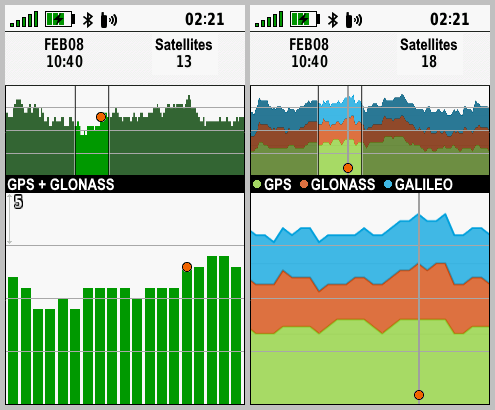
| 114. | The GPSMAP 66s/st consistently locates fewer Galileo satellites than comparable Garmin devices when used side by side. | [250] [280] [290] [300] [310] [320] [330] [340] [410] [420] [470] [480] [490] [500] [600] [700] [710] [720] [730] [740] [760] [960] | |
| 115. | Configuring [Setup > Waypoints > Suffix = 0000] results in a value of '10000' being displayed in the setup menu with the next marked waypoint using the next free suffix number counting up from '0000'. [Gr] | [600] [700] | |
| 116. | After selecting and beginning navigation to a geocache, the Geocache List Tab may be displayed instead of the Active Geocache Tab. | [720] [730] [740] [760] [960] | |
| 117. | The user interface has become noticeably sluggish and slow to respond to user input with firmware version 7.20. | [720] [730] [740] [760] [960] | |
| 118. | GCLive downloads seem to require a substantially longer period of time to complete with firmware version 7.20. | [720] [730] [740] [760] [960] | |
| 119. | With Trip Recording configured for 'During Activity' and Activity Recording paused or inactive, the Recording Controls Activity Plot Tab accumulates 'Total Ascent' data while the Information Tab continues to display no change for the same value. | [720] [730] [740] [760] [960] [990] [1000] [1010] [1020] [1030] [1050] [1070] | |
| 120. | Geocache Photos can not be selected or viewed when no other JPEG images exist on the device or microSD card. [Gr] | [720] [730] [740] [760] [960] [990] [1000] [1010] [1020] [1030] [1050] [1070] | |
| 121. | After [A.] selecting a data point on the Map page with the cursor and pressing (Enter), the data point, cursor, and shadow are displayed in duplicate below the originals, and the status bar is no longer displayed. When [B.] pressing (Menu) > (Menu) immediately after, the status bar returns in duplicate and the Main Menu is displayed partially off screen. [example] | [720] [730] [740] [760] [960] | |
| 122. | Compass may fail to respond while the device is in motion. [example] [Gr] [Garmin: "This is normal and correct behavior."] [Related: Feature Request 39] | [600] [700] [710] [720] [730] [740] [760] [960] | |
| 123. | Map page waypoint name text does not honor display mode changes. User must disable then enable text display in Map Setup to force correct text display for current display mode. See Montana 7x0 forum post for details. | [720] [730] [740] [760] [960] | |
| 124. | Keyboard language selection is not retained across power cycles. | [720] [730] [740] [760] [960] | |
| 125. | Opening the Alarm Clock page and pressing (Menu) > selecting [Timer] > pressing (Enter) results in erratic display page confusion. [example] | [740] [760] | |
| 126. | Changing the Route Activity while navigating any route with Via Points results in all Via Points being stripped from the route. | [740] [760] [960] | |
| 127. | Text for 'Area' data field on the 'Recording Controls' and 'Save Activity' pages may be displayed partially off screen. [Gr] | (1115) | [720] [730] [740] [760] [960] [990] [1000] [1010] [1020] [1030] [1050] [1070] |
| 128. |
While viewing waypoints listed in any Adventure
Content menu;
|
[760] [960] [990] [1000] [1010] [1020] [1030] [1050] [1070] | |
| 129. |
Saved Track and Recording
Controls Elevation Plot Cursor Control Issue - The behavior described below in step 8 should (is expected to) occur following
steps 6 and 7, not the behavior described in step 9: [Gr]
|
[420] [470] [480] [490] [500] [600] [700] [710] [720] [730] [740] [760] [960] [990] [1000] [1010] [1020] [1030] [1050] [1070] | |
| 130. | Saving an Activity may result in the Recording Controls page being displayed completely blank or empty other than the Track Color. Pressing the D-PAD may add ")" to the display. [Example] [Gr] | [960] [990] | |
| 131. | With [Setup > Units > Pressure = Hectopascals] configured, the Ambient Pressure and Barometric Pressure data fields are displayed in Pascals 'Pa'. | [420] [470] [480] [490] [500] [600] [700] [710] [720] [730] [740] [760] [960] [990] [1000] [1010] [1020] [1030] [1050] [1070] | |
| 132. | After selecting a geocache child waypoint via 'Additional Waypoints', the 'Activity' selection menu does not include the 'Direct' option, and after selecting any option the user is returned to the 'Activity' selection menu with 'Direct' listed again. | [960] [990] | |
| 133. | Attempting BirdsEye Direct satellite imagery downloads may result in 'Waiting for connection to BirdsEye imagery servers.' message being displayed for an abnormally long period of time. | [960] [990] | |
| 134. | Active Weather page no longer provides forecast information after updating to firmware version 9.60. | [960] [990] | |
| 135. | [Setup > Routing > Activity] configuration is not respected when selecting [Where To? > {any course} > Roads & Trails > Go]. [Gr] | [960] [990] [1000] [1010] [1020] [1030] [1050] [1070] | |
| 136. | Expedition Mode rapidly drains the battery and fails to save expected track points after updating to firmware version 9.60. [Gr] | [960] [990] | |
| 137. | When resuming from Expedition Mode, the user configured GNSS settings are not remembered or restored. [Gr] | [420] [470] [480] [490] [500] [600] [700] [710] [720] [730] [740] [760] [960] [990] | |
| 138. | 'On Track' and 'Off Track' notification alarms provide no options to disable or configure alert sensitivity. [Gr] [Gr] [Garmin] | [960] [990] [1000] [1010] [1020] [1030] [1050] [1070] | |
| 139. | Downloading geocache PQ's and Lists via GCLive (Bluetooth and/or Wi-Fi) frequently fails to complete, and may render the device unresponsive to user input. [Gr] | [960] [990] [1000] [1010] [1020] [1030] [1050] [1070] | |
| 140. | Tracks recorded while Expedition Mode is active may result in a saved GPX file that does not agree with the FIT file for the same activity. [Gr] | [990] [1000] [1010] [1020] [1030] [1050] [1070] | |
| 141. | While navigating to any destination, opening the Elevation Plot Tab in the Recording Controls Page, pressing (FIND) and selecting [Stop Navigation] always returns the user to the Elevation Plot Page instead of the Elevation Plot Tab in the Recording Controls Page. | [990] [1000] [1010] [1020] [1030] [1050] [1070] | |
| 142. | After selecting a geocache child waypoint via 'Additional Waypoints' and selecting 'Direct' in the 'Activity' selection menu, the Map page fails to display the magenta route line between the user's current position and the destination. | [990] [1000] [1010] [1020] [1030] [1050] [1070] | |
| 143. | The 'Reverse Course' selection is missing from the Course Planner option menu after updating to firmware version 9.90. | [990] [1000] [1010] [1020] [1030] [1050] [1070] | |
| 144. | Geocaching 'Next Stage' feature fails for geocaches with more than one 'Next Stage'. [groundspeak] | [990] [1000] | |
| 145. |
A. Open Course Planner, select any course, wait for the course to be
calculated, then select the Map Tab and the selected course is displayed
on the map. B. Press (QUIT), select any other course, and course information for the previously selected course (A) is displayed (no course is calculated). Select the Map Tab and the previously selected course (A) will be displayed on the map. |
[990] [1000] [1010] [1020] [1030] [1050] [1070] | |
| 146. | Map page POI's are no longer displayed after updating to firmware version 10.10. [Gr] | [1010] [1020] | |
| 147. | Embedded POI information may be displayed incomplete and/or include additional text fragments 'ÿ' and/or no longer be formatted left justified after updating to firmware version 10.20. [Gr] | [1020] [1030] [1050] [1070] | |
| 148. | Total Ascent values appear to be calculated incorrectly, especially when compared to similar models. [Gr] | (1216) | [300] [310] [320] [330] [340] [410] [420] [470] [480] [490] [500] [600] [700] [710] [720] [730] [740] [760] [960] [990] [1000] [1010] [1020] [1030] [1050] [1070] |
| 149. | Recorded Activities page may load incomplete and/or incorrect activity data and fail to respond to user input. | [1020] [1030] [1050] [1070] | |
| 150. | Data from Garmin Speed Sensor 2 is not included in Tracklog Recordings, nor is it used to update speed related data fields. | [1000] [1010] [1020] [1030] [1050] [1070] | |
| 151. | When attempting to send a course via Share Wirelessly, the device instead enters navigation mode. | [960] [990] [1000] [1010] [1020] [1030] [1050] [1070] |
Crash Reports
| 1. | Selecting [Waypoint Manager] > [Menu] > [Delete All] > [Delete] always results in a device crash. | (745) | [210] [250] |
| 2. | After editing next stage coordinates in Geocaching page and selecting 'Done', GPSMAP 66 frequently locks up and crashes after returning to Geocache Menu. | [210] | |
| 3. | With [Map] > [Setup] > [Dashboards] =
[Custom] + [Map] > [Setup]
> [Dashboards] > [When Navigating] = [Automotive] + [Map] > [Setup] >
[Dashboards]
> [When Not Navigating] = {abc} + Map page open + Navigating to a
destination + Press (Menu) and select [Stop Navigation] results in a
device crash, where {abc} =
|
(753) | [250] [280] [290] |
| 4. | Selecting [Waypoint Manager] > (Menu) > [Select Symbol] > {any symbol} > [Menu] > [Delete All] > [Delete] results in a device freeze and/or crash. [Gr] [Instead of solving the underlying issue, the Garmin software engineers solution was to completely remove this (commonly available on other Garmin products) feature from the device, creating Bug 46 in the process] | (756) | [250] [280] [290] |
| 5. | When navigating to the 'second' 'next stage' of a multi-cache after having just 'found' a multi-cache with multiple stages, the GPSr will freeze and/or crash. [groundspeak] | [250] [280] [290] [300] [310] [320] [330] [340] [410] [420] [470] | |
| 6. |
Performing the following procedure to move a waypoint on the Map Page frequently
results in a device
freeze and/or crash: [Gr]
|
(818) | [250] [280] [290] [300] [310] |
| 7. | Panning the Map page with specific maps enabled frequently results in a complete lockup, requiring a battery pull/install to restart the device. Similar Garmin GPSr models do not exhibit this behavior when tested with the same maps. [video] [groundspeak] [Gr] | [340] [410] [420] [470] | |
| 8. | (Find) > [Cities] search function may intermittently result in a device crash. (may be related to bug 73) [video] [Gr] | [310] [330] [340] [410] [420] [470] [480] [490] [500] [600] [700] [710] [720] [730] [740] [760] [960] [990] [1000] [1010] [1020] [1030] [1050] [1070] | |
| 9. | Navigating to a geocache and selecting [Where To?] > [Stop Navigation] or pressing (Find) > [Stop Navigation] without logging the geocache (or navigating to a waypoint, route, etc. without arriving at destination) frequently results in a device hang or crash, requiring a battery pull to reboot device. [Gr] | [340] [410] [420] [470] [480] [490] [500] [600] [700] | |
| 10. | When manually adding a Wi-Fi network, after entering the [SSID] and [Password] and then selecting [Connect], the GPSMAP 66 crashes. (may be related to bug 87) [Gr] [Gr] | [470] [480] [490] [500] [600] [700] | |
| 11. | Selecting [Share Wirelessly > Send > Custom Maps > D-PAD {Left or Right}] when no custom maps are loaded on the device can result in a device crash. [garmin] | [490] [500] [600] [700] [710] [720] [730] [740] [760] [960] [990] [1000] [1010] [1020] [1030] [1050] [1070] | |
| 12. | Selecting (Find) > [Recorded Activities] > (Enter) > [Current Activity] > (Enter) frequently results in a device crash. [Gr] | [720] [730] [740] | |
| 13. | Selecting (Menu) > (Menu) > [Proximity Alarm] > [+ Create Alarm] > [Attractions] or [Entertainment] or [Recreation] or [Waypoints] > {any category} > {any location} > [Use] > (Enter) > (D-PAD Down) frequently results in a device crash. [video] [Gr] | [720] [730] [740] [760] [960] | |
| 14. | Selecting (Find) > (Menu) > [Search Near] > [A Map Point] or [A Recent Find] always results in a device crash. [Gr] | [960] [990] | |
| 15. | Saving an Activity may result in a frozen Recording Controls page followed by a device crash. [Gr] | [960] [990] | |
| 16. | Attempting to download BirdsEye Direct satellite imagery always results in a device crash. [Gr] | [960] [990] |
Hardware Failures
| 1. | After only a few weeks of use, the Micro-USB connector in the GPSMAP 66 has become very sloppy and loose fitting, allowing inserted USB cables to move around freely, frequently resulting in an 'external power lost' shut down due to unintentional cable release/poor connection. | ||
| 2. | GPSMAP 66 users should be aware the bayonet lock for the battery cover is not IPX7 sealed, which can lead to corrosive build-up and potential failure when used in or near salt water environments. Special care should be taken to inspect and clean the bayonet locking mechanism regularly. [example] [Gr] | ||
| 3. | GPSMAP 66 users should be aware of a potential battery cover seal failure when using certain AA batteries. [groundspeak] | ||
| 4. | Garmin GPSr employing hinged microSD card connections may fail to read data from an installed microSD card after the hinge lock is dislocated during rugged use or (more commonly) after a battery change is performed. [Gr] |
Missing Features
| 1. | Please improve child waypoint management within the Geocaching User Interface, providing direct access to child waypoints for the active geocache, similar to the Monterra. [Gr] | [470] | |
| 2. | Geocaching with Photos support seems to be MIA. Most Garmin outdoor models since the Colorado have had this feature, including the GPSMAP 62/64 series. [groundspeak] | (943) | [700] |
| 3. | Please include the '2 Small Data Fields' dashboard option available with previous GPSMAP series. [Gr] | ||
| 4. | Shortcuts to the Geocaching and Geocache Filters Pages are missing from the Map Page (Menu) when active navigation destination is a geocache. [Gr] [groundspeak] | (794) | [320] |
| 5. | GPSMAP 66 does not ignore 'shaping points' set to 'will not alert' in routes created/edited in BaseCamp. [Gr] | (838) | |
| 6. | Shortcuts to the Geocaching and Geocache Filters Pages are missing from the Compass Page (Menu) when active navigation destination is a geocache. [Gr] [groundspeak] | (794) | |
| 7. | Please return 'Time to Destination' and 'Distance to Destination' data fields to Active Route list, similar to previous Garmin GPSr [eTrex Vista HCx] [Gr] | ||
| 8. | Map points triggering a Proximity Alert are not highlighted on the Map page display like they are on previous models such as the eTrex Vista HCx. [Gr] | ||
| 9. | User is unable to add Via Points while navigating using Direct Routing. | ||
| 10. | The Photo Viewer page fails to rotate images when held in landscape orientation, unlike previous generation GPSMAP 62/64 series and current generation GPSMAP 65 series devices. | ||
| 11. | Trip Computer data field values are not updated while alerts or messages are displayed on the screen. [Gr] |
Requested Features
| 1. | Please include option to auto-upload logs to geocaching.com as a draft ('Field Notes'), allowing the user to edit them at a later time before publishing as a log. [Gr] [groundspeak] | ||
| 2. | Requiring nearly three hours time to download 60MB of BirdsEye Direct satellite imagery is... impractical to say the least. Please increase server speeds for this service. [example] [Potential Improvement in v300] | [300] [470] | |
| 3. | Please update the unit firmware to allow battery charging from external power sources while in Expedition Mode (skipping the auto-shutdown process after the external power supply is removed, keeping the unit in Expedition Mode). | ||
| 4. | Please update unit firmware to track and display 'DNF' geocaches using a 'Blue Frown' 'Geocache DNF.bmp' symbol the user can modify via 'CustomSymbols' directory. (Geocaching.com tracks DNF's, so should our GPSr!) | ||
| 5. | Please add an option to disable the automatic power off countdown each time external power is lost (add 'Always {shut down} or {stay powered}' selection - similar to GPSMAP 60 series). [Gr] | ||
| 6. | Please include function to enable review and editing of geocache log notes saved on the device. [Gr] [Gr] | ||
| 7. | Please update Geocache Descriptions to include Attribute information. | ||
| 8. | Please add an option to 'Save Current Filter' in [Geocaching] > (Menu) > [Filter] > [Menu]. | (774) | |
| 9. | Please update the Geocaching page Map Tab display (only - not the primary Map page) to include a progress bar indicating GCLive download progress (not GC List progress). [example] [Gr] [groundspeak] | ||
| 10. | Please provide an alternate method (other than the power button) for the user to Lock and Unlock the Keys. [Gr] | ||
| 11. | Please include both hddd°mm.mmm' and hddd°mm.mmmm' options in [Setup] > [Position Format]. (related to Bug 41). [groundspeak] | (777) | |
| 12. | Please include options for [Hide Dashboard] and [Show Dashboard] in the Map Page menu when a dashboard is enabled. | [320] | |
| 13. | Please include 'Custom POIs' category when (A) 'changing item order' of the Find Menu icons, and when (B) adding a 'Where To?' category to the Main Menu (Sequence). [Gr] [Gr] | ||
| 14. | Please update firmware to display geocache log dates in format specified by user. [Gr] | ||
| 15. | To minimize battery consumption, please reduce or disable the keyboard and display backlighting that occurs when any button is pressed while the keys are locked. [Gr] | ||
| 16. | With [Setup] > [Display] > [Battery Save] = [On], it is impossible for the user to determine if the GPSMAP 66 is in Battery Save Mode or powered off. Pressing the Power Button either exits Battery Save Mode or starts an undesired boot sequence if powered off. Perhaps the unit could briefly illuminate the key pad buttons when pressed while Battery Save Mode is active, or pulse the Notification LED (two quick pulses every 5 or 10 seconds) to indicate the unit is still powered on? [Gr] | ||
| 17. | Please update Wi-Fi settings to support WPS (WiFi Protected Setup) [Gr] | ||
| 18. | Please incorporate a new 'Satellite Availability' or 'Satellite Visibility' page for current and future models. [examples] | ||
| 19. | Please add Elevation Delta to Map page Info Box (currently only shows direction and distance) for cursor position when panning map. [Gr] | ||
| 20. | Please add 'Full Scale' option to Elevation plot menu to automatically adjust the Y axis such that the top of the graph display is equal to the highest recorded value and the bottom of the graph display is equal to the lowest recorded value. [Gr] [Gr] | ||
| 21. | Please introduce a simple notepad page that allows the user to create, edit and save geo-tagged alpha-numeric notes for future reference. [Gr] | ||
| 22. | As so many device settings are now global and no longer profile dependent, preventing the device user from creating their own low power consumption and/or high power consumption profiles, please create dedicated profiles for each (not expedition mode), or return control of device settings to the user creating their own profiles. Or compromise, and add an additional 'Global/Profile Dependent' option for settings that are currently Global only. [Gr] | ||
| 23. | Please include a menu option to enable the serial port without the need for the device being externally powered (like older models once did) to allow APRS tracking. [Gr] | ||
| 24. | Please include a menu option to 'Download BirdsEye' in the Map page menu for all devices equipped with BirdsEye Direct. | ||
| 25. | Please include an option to display time as HH:MM:SS in Status Bar. [Gr] | ||
| 26. | The Elevation Plot application currently allows the user to view 'Elevation/Time', 'Elevation/Distance', 'Barometric Pressure', or 'Ambient Pressure' data. Please include option to view 'Temperature', 'Heart Rate', 'Cadence', 'Calories' and other data, when available. [Gr] | ||
| 27. | Please
include a 'Status Bar Notification Icon' to indicate current 'Recording
Controls' Activity Recording status, similar to inReach Tracking
notification icon on inReach equipped devices (active " |
||
| 28. | Please display 'Calories' data field as kilocalories or 'kcal' when [Setup > Units > Temperature = Celsius]. [example] [Gr] | (988) | |
| 29. | Please link the display of track navigation high/low point symbols to the Map page user waypoint zoom value, providing the user with some control over when they are displayed. | ||
| 30. | Improve geocache database functionality to download GCLive data for geocaches already present in GPX/GGZ format, allowing the user to choose between using GCLive or GPX/GGZ files when enabling or disabling 'Live Data' in [Geocaching] > [Filters] > [Geocache Files]. | ||
| 31. |
Please enhance POI Alerts to include a 'Flash Display'
option for users that: [Gr]
|
||
| 32. | Please complete FIT file support to provide full import/export/navigation functionality similar to other fitness products. [Gr] | ||
| 33. | Please add 'Download Geocaches' selection to Map page option menu. | ||
| 34. |
Please enhance the 'MARK' button function as follows: [Gr]
|
||
| 35. | The Geocache Proximity Alert feature currently only allows the user to 'Dismiss' an alert. Please also include the option to 'Begin Navigation' to the displayed geocache. [Gr] | ||
| 36. | Please include 'Most Recent' selection in Waypoint Manager 'Sort' option menu, similar to the existing Track Manager sort option menu. [Gr] | ||
| 37. | Please add an option allowing the user to configure the total number of geocaches used to populate the Geocache List. [Gr] | ||
| 38. | Please include an option to enable/disable the Barometric Altimeter (similar to Montana 7x0). | ||
| 39. | Please introduce a profile dependent setting to configure the speed when the compass switches from magentic to GPS operation. [Gr] [Related: Bug 122] | ||
| 40. | Please add 'Ascent to Next', 'Ascent to Dest', 'Descent to Next', and 'Descent to Dest' data fields. | ||
| 41. | Please add support for third party JNX raster maps. |