
Thanks gprsrchive
I first reported this to Garmin Europe Product Support on April 17 (Reference ID: 13818607K0) and they have all the details with files and screenshots etc.
Elevation Spikes in Expedition Mode [Bug 51]
-
Spiney
- Posts: 65
- Joined: Thu Apr 04, 2019 9:35 am
-
GPSrChive

- Site Admin
- Posts: 3920
- Joined: Fri Jan 20, 2017 11:29 pm
Re: Elevation Spikes in Expedition Mode [Bug 51]
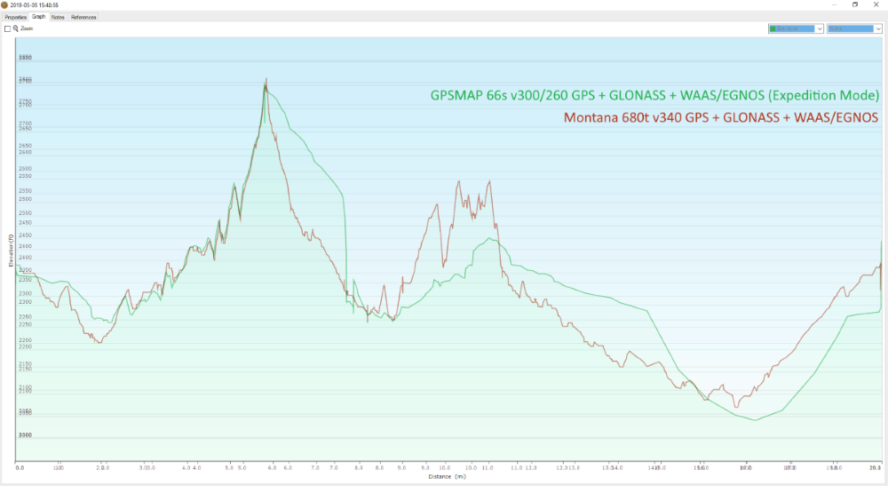
I just performed a test today, about 20 miles and 4 hours in length.
I used a GPSMAP 66s v300 (GPS 2.60) in Expedition Mode vs a Montana 680t v340, both with GPS + GLONASS + WAAS/EGNOS enabled.
The Elevation Profile results can be seen here:
I used a GPSMAP 66s v300 (GPS 2.60) in Expedition Mode vs a Montana 680t v340, both with GPS + GLONASS + WAAS/EGNOS enabled.
The Elevation Profile results can be seen here:
-
CheminerWill
- Posts: 140
- Joined: Wed Dec 19, 2018 4:42 am
Re: Elevation Spikes in Expedition Mode [Bug 51]
I have not encountered this specifically but have the following. When I trace 1/2 of a trail and then come back a week or so later to get the rest, the two tracks are often as much as several hundred feet different at the point the first track ends and the 2nd starts. This difference continues for the entirety of the 2nd track. This even though I am standing at the exact same Lat/Long for both.
-
GPSrChive
- Site Admin
- Posts: 3920
- Joined: Fri Jan 20, 2017 11:29 pm
Re: Elevation Spikes in Expedition Mode [Bug 51]
What are your Altimeter settings for Auto Calibration and Barometer Mode?CheminerWill wrote: ↑Mon May 06, 2019 7:48 pm I have not encountered this specifically but have the following. When I trace 1/2 of a trail and then come back a week or so later to get the rest, the two tracks are often as much as several hundred feet different at the point the first track ends and the 2nd starts. This difference continues for the entirety of the 2nd track. This even though I am standing at the exact same Lat/Long for both.
-
rogerm
- Posts: 13
- Joined: Sat Mar 09, 2019 3:19 pm
Re: Elevation Spikes in Expedition Mode [Bug 51]
I took a look at an elevation plot from my device on a canoe trip yesterday. I only had expedition mode on for a fairly short time. When expedition mode was off, elevation was pretty constant at 220m. When expedition mode was on, elevation was constant at 110m aside from a few points that were at 220m. I don't know if the points at the correct elevation correspond to when I woke it since I didn't mark waypoints though it's plausible.
I was wanting to install the 2.60 version of the GPS Software to see if it helps me though Garmin Express doesn't want to offer it and it seems I can no longer use Webupdater (it always wants to install a newer version, which invariably fails with a cryptic error code).
I was wanting to install the 2.60 version of the GPS Software to see if it helps me though Garmin Express doesn't want to offer it and it seems I can no longer use Webupdater (it always wants to install a newer version, which invariably fails with a cryptic error code).
-
Spiney
- Posts: 65
- Joined: Thu Apr 04, 2019 9:35 am
Re: Elevation Spikes in Expedition Mode [Bug 51]
Interesting ... did you wake-up the 66s from EM during your walk? If so at what distances? It looks like you did a spot of rappelling at around 7 miles according to the 66s!
Here are a few of my elevation plots:
This is a plot from a friends 66st (blue) in EM compared to my 66st (green) in normal mode (both running GPS 2.50 and 2.80 software) - we are fairly sure (we weren't checking this then) each spike in the blue plot occurred when the device was brought out of EM:
This is a plot showing a short walk where every spike was where my device (GPS 2.50/Software 2.80) was woken from EM.
Here is another test, a short out and back walk. Out: device (GPS 2.50/Software 2.80) in EM but not "woken-up". Return: device in EM but "woken-up" five times, each one causing a spike:
Here is my last test with the device running the updated (GPS 2.60/Software 2.80) firmware, which still has the spikes issue:
Last edited by GPSrChive on Tue May 07, 2019 10:29 am, edited 1 time in total.
-
GPSrChive
- Site Admin
- Posts: 3920
- Joined: Fri Jan 20, 2017 11:29 pm
Re: Elevation Spikes in Expedition Mode [Bug 51]
Twice. And each time the GPSr indicated it had no GPS signal and I was unable to use it to mark waypoints etc. Each time I just let it drop back into EM mode knowing I would check the track log when I returned home.
-
CheminerWill
- Posts: 140
- Joined: Wed Dec 19, 2018 4:42 am
Re: Elevation Spikes in Expedition Mode [Bug 51]
They are at the original settings from the reset of the device I did a while ago. Auto Calibration is "Once". Barometer Mode is "Variable Elevation"gpsrchive wrote: ↑Mon May 06, 2019 7:57 pmWhat are your Altimeter settings for Auto Calibration and Barometer Mode?CheminerWill wrote: ↑Mon May 06, 2019 7:48 pm I have not encountered this specifically but have the following. When I trace 1/2 of a trail and then come back a week or so later to get the rest, the two tracks are often as much as several hundred feet different at the point the first track ends and the 2nd starts. This difference continues for the entirety of the 2nd track. This even though I am standing at the exact same Lat/Long for both.
-
GPSrChive
- Site Admin
- Posts: 3920
- Joined: Fri Jan 20, 2017 11:29 pm
Re: Elevation Spikes in Expedition Mode [Bug 51]
There you go. The GPSMAP 66 is auto calibrating 'Once' per power cycle, when the unit is first powered up. If you had performed a manual calibration at the point where you were starting the second half of the track recording, or performed a manual calibration at the exact same starting point from the first half, then moved to the second half before recording data, the elevation profiles likely would have been very similar.CheminerWill wrote: ↑Tue May 07, 2019 5:14 pmThey are at the original settings from the reset of the device I did a while ago. Auto Calibration is "Once". Barometer Mode is "Variable Elevation"gpsrchive wrote: ↑Mon May 06, 2019 7:57 pmWhat are your Altimeter settings for Auto Calibration and Barometer Mode?CheminerWill wrote: ↑Mon May 06, 2019 7:48 pm I have not encountered this specifically but have the following. When I trace 1/2 of a trail and then come back a week or so later to get the rest, the two tracks are often as much as several hundred feet different at the point the first track ends and the 2nd starts. This difference continues for the entirety of the 2nd track. This even though I am standing at the exact same Lat/Long for both.
-
CheminerWill
- Posts: 140
- Joined: Wed Dec 19, 2018 4:42 am
Re: Elevation Spikes in Expedition Mode [Bug 51]
I can do that but if it is calibrating once upon starting up, should it not be correct for that whole power cycle? So if I power on the unit and do the first 1/2 of the track, it should be calibrated and correct on the elevation. If a week later I then power up and it does a calibration again, why would it be off from the first half? I must be missing how this works, but if it calibrates automatically each time it is powered on, why would that be a problem?gpsrchive wrote: ↑Wed May 08, 2019 3:41 am There you go. The GPSMAP 66 is auto calibrating 'Once' per power cycle, when the unit is first powered up. If you had performed a manual calibration at the point where you were starting the second half of the track recording, or performed a manual calibration at the exact same starting point from the first half, then moved to the second half before recording data, the elevation profiles likely would have been very similar.